Mission Log: Sept. 20, 2006
by Noah Doughty, NOAA Teacher at Sea
As the mosaic work continued on the sea floor I was able to briefly pull the three Principal Investigators (PI) away from the action to ask questions regarding the history of the MACON and the eventual plans for the wreck site.
| Mission Weather Report |
Visibility: Fair
Wind direction and speed: calm
Swell direction and height: WNW 8-9’
Seawater temperature: 56.1oF
Sea level pressure: 1023.0 millibars
Cloud cover: 8/8 |
The three PI’s are Chris Grech, of the Monterey Bay Aquarium Research Institute (MBARI), Robert Schwemmer, West Coast Regional Maritime Heritage Program Coordinator based out of the Channel Islands National Marine Sanctuary (CINMS), and Bruce Terrell, a Senior Archeologist for NOAA’s National Marine Sanctuary Program. Their answers are summarized below:
Question 1: Has the condition of the wreckage changed since the first visit in 1991?
Grech: Yes. There is more sediment on the bottom than before. Some of the smaller pieces of debris are no longer visible. Meaning they have been moved, covered up, or corroded. Overall the major features are still there, the Sparrowhawks and the Maybach engines.
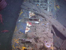 |
| Underwater image of the Curtiss Sparrowhawk F9C-2 port wing. Note it is still possible to make out the Navy Star painted on the wing fabric. |
Question 2: What technology is being employed this time that wasn’t employed before?
Grech: We are using a High Definition camera and HMI lights on the Tiburon. The HMI lights are high-powered underwater lights. We know the position of the Tiburon relative to the Western Flyer through the use of USBL (Ultra Short Base Line) technology. Central to the effort is the Stanford Control System, which provides computer aided ROV control enabling us to create the site photo-mosaic. At the same time we are using GIS (Geographical Information System) technology to create a map tied to geographical coordinates. The Stanford Control System and GIS software is run separately but their use is closely linked. Finally the WESTERN FLYER is able to maintain her position through Dynamic Positioning, a system where a GPS (Global Positioning System) coordinate is set and the ship is automated to maintain that position.
Question 3: What might eventually happen to the wreck site in terms of protection policy?
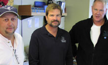 |
| Principal Investigators, left to right: Chris Grech (MBARI), Robert Schwemmer (CINMS), and Bruce Terrell (NMSP) |
Terrell/Schwemmer: The Macon already has the ultimate protection regimen. The wreckage is within the boundaries of the Monterey Bay National Marine Sanctuary, and the Sanctuary has a clearly defined mandate to protect archeological resources. The US Navy still owns the Macon and the Navy has its own legislation to protect submerged vessels and aircraft. Last, the wreck site is within State of California waters and so is protected by state law. From the data gathered on this cruise we will do three things. First is to generate a report on the project that will go to the NOAA Office of Ocean Exploration, who provided much of the funding. Second will be an archeological assessment that will go to the National Marine Sanctuary Program and to peers. This assessment will include management recommendations regarding the values and needs of the wreck site. Third will be to begin the process to nominate the Macon to the National Register of Historic Places. This is a one to two year process. |