|
Upcoming 2006 Expedition to the USS Macon
From September 18-21, researchers will revisit the Macon. The primary goal of the mission is to conduct a comprehensive documentation of the site of the USS Macon’s loss. This will allow NOAA’s National Marine Sanctuary Program (NMSP) and the U.S. Navy Historical Center to determine the condition of the site, the level of preservation of the archaeological remains and the potential for research at the site. The wreck lies within Monterey Bay National Marine Sanctuary.
 |
|
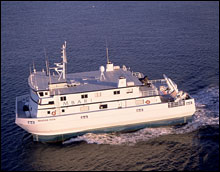
The R/V Western Flyer is MBARI's flagship research vessel and mother ship for the ROV Tiburon. The vessel is about 36 meters (118 feet) long and 16 meters (52 feet) wide. It has twin hulls whose deep pontoons can be partially filled with water for extra stability in rough seas. The R/V Western Flyer has a range of up to 4000 nautical miles, and has suppported Tiburon dives all around the Eastern Pacific Ocean from Vancouver to Hawaii and Baja California. (Photo: M. Leet/MBARI)
|
Working in collaboration with the Monterey Bay Aquarium Research Institute (MBARI), the expedition team will utilize the 117-foot research vessel Western Flyer, a small waterplane-area twin hull (SWATH) oceanographic ship. The vessel provides a stable platform for deploying, operating, and recovering a tethered remotely operated vehicle (ROV) and capable of working at the required depth of the Macon site.
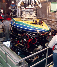
The ROV Tiburon will be deployed from the Western Flyer, which has a maximum working depth of 13,123 feet (4000 meters). Tiburon is equipped with adjustable high-definition video cameras and coordinated lighting. A high-resolution video camera system is currently being configured for this mission by Stanford University to be used in conjunction with an ROV control system. The ROV is also equipped with imaging sonar, which is key to maneuvering around a wreck site to avoid entanglement and scan the sea floor for further debris fields.
 |
|
MBARI's Remotely Operated Vehicle (ROV) Tiburon being launched into the moonpool on board the R/V Western Flyer. This unmanned submarine is launched and recovered through two folding doors located between the Western Flyer's two hulls. The ROV can dive to 4000 meters (about 2 1/2 miles) depth, and is controlled using a very long cable, which also transmits data and video images back to the ship. The brightly colored upper portion of the ROV is constructed of incompressible foam, whose buoyancy makes the 3 1/2 ton ROV nearly weightless in seawater. (Photo: Greg Pio/MBARI)
|
The first goal is to fly Tiburon above the wreck site and systematically record the visual remains of the airship and aircraft through high-definition video and high-resolution still photography. After the expedition, the imagery gathered will be used to create a photomosaic of the two major debris fields, as well as any new debris fields discovered. The photomosaic will provide a visual reference of the full magnitude of the wreck site and assist in the site documentation and interpretation as well as produce imagery for education and outreach efforts.
The second goal of the expedition is to record in more detail specific artifacts utilizing Tiburon’s still camera, video zoom, pan/tilt cameras, and parallel laser system for measuring. The 2006 expedition will examine the aluminum structural remains of the airship and aircraft. After the expedition an analysis will be conducted to compare the 2006 visual record to the site documentation in 1990/91. This may provide important data on the rate of degradation of aluminum in a deep sea saltwater environment.
Both phases of the survey will assist in meeting the mandates of the National Historic Preservation Act, which directs federal programs managing public lands to survey and inventory historical and archaeological properties and nominate them to the National Register of Historic Places and the National Marine Sanctuaries Act, which directs the NMSP to manage and protect archaeological resources such as the Macon site. This expedition will aid in the assessment of the USS Macon and four Curtiss F9C-2 Sparrowhawk aircraft for eligibility to the National Register of Historic Places.
A third goal of the expedition is to conduct a biological survey. Video footage and images from the 1991 survey of the USS Macon indicate the submerged remains serve as an artificial reef in the deep sea. To characterize the habitat and species composition associated with the wreck (and surrounding area), a biological survey will be conducted using a remotely operated vehicle equipped with digital video camera and still camera. Due to the irregular debris field (i.e. potential navigation hazards), a qualitative survey will be conducted. Species composition, size composition, habitat description, and species-habitat associations at the wreck site will be identified. Such a survey will characterize species occurring on wrecks in deep water and will add to the body of knowledge for management and protection of sanctuary resources.
|