|
Mission Log: July 16, 2006
Wrapping up and Heading Home
Kelly Gleason
Maritime Archaeologist
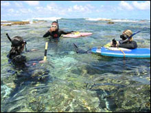 |
| Maritime archaeologists Hans Van Tilburg, Kelly Gleason and Lindsey Thomas discuss discoveries on the reef crest at Kure Atoll. (Photo: Tane Casserley) |
After 15 days of dive operations off of the Hi’ialakai’s small boats, the maritime archaeology team is finally able to step back and realize the incredible experience they have had in the Northwestern Hawaiian Islands. Heading into the field over twenty days ago, the team had high hopes for good weather and calm conditions that would allow them access to several important wreck sites. Most of the shipwreck sites in the Northwestern Hawaiian Islands are located in dynamic spots on the reef crest. Good weather is key for successful field operations in this region. Fortunately, it was not until the final days of the expedition at Pearl and Hermes Atoll that weather became an issue, and even then, it did not prevent the maritime archaeology team from heading out and conducting work. Final days at Pearl and Hermes Atoll included dives to take additional measurements at the “Oshima” wreck site and the area surrounding the engine block. Also, the team spent a day battling challenging current inside the reef to survey for more shipwreck scatter where the Pearl and Hermes wrecked just outside of the reef.
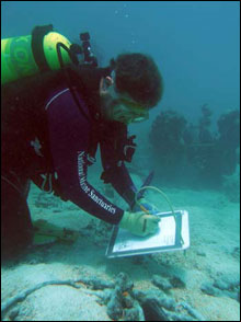 |
| Tane Casserley documents a windlass at the Oshima wreck site. (Photo: Brenda Altmeier) |
The transit back to Honolulu takes about five days, and during this time scientists are busy packing up gear, and completing the drafts of site maps from the whaling ship Pearl and the “Oshima” wreck site at Pearl and Hermes Atoll. Because the transit back to Honolulu is often a bumpy ride, the maritime archaeology team decided to wait until conditions calm down to complete the site maps with ink on vellum paper. There are many important products that come out of a field expedition like this one. Reports, digital images, site maps and videos are just a few. Our job as maritime archaeologists for NOAA’s Maritime Heritage Program is to interpret all that we have seen and documented for the public and to help manage these non-renewable resources. We have been fortunate during the 2006 field season to uncover so much evidence of this region’s seafaring history in the Northwestern Hawaiian Islands. With each annual expedition to this remote location, NOAA maritime archaeologists are unlocking more of this region’s past, and helping to bring this unique place to the public.
|