|
Mission Log: July 20, 2006
A Comb in the Pacific - Marine Debris Collection Efforts in the NWHI
Paulo Maurin, University of Hawaii
Deena Deck, Bellflower Unified School District, California
with the help of Kyle Hogrefe, NOAA Coral Reef Ecosystem Division
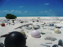 |
| Plastic marine debris from afar floated to Green Island, Kure Atoll, littering this remote island. (Photo: NOAA Coral Reef Ecosystem Division) |
Because of their remoteness, the largely uninhabited, and dynamic ecosystems of the Northwestern Hawaiian Islands are often thought of as pristine environments. A more accurate term is “near-pristine,” because this isolated archipelago acts as a giant filtering comb in the middle of the Pacific Ocean, picking up debris that float from afar. Signs of trouble are not immediately apparent to the casual observer, but a closer look reveals ghost nests (discarded or lost fishing nets) caught on the reefs, debris of all sorts on the beaches, and plastics inside the skeleton of albatrosses. Even here, pollution has left its mark. But it is not an indelible mark, and there are devoted groups working hard to erase it from the map of the Northwestern Hawaiian Islands.The majority of the debris that accumulates on these islands is fishing gear, and lots of it. In addition to destroying the coral upon which it settles, derelict fishing gear can also cause entanglement for the highly endangered Hawaiian monk seal, the threatened green sea turtle, fish, invertebrates, and seabirds.
The Northwestern Hawaiian Islands are in the path of the North Pacific Subtropical Convergence Zone, which stretches from Japan to the West Coast of the US. This zone is a large, shifting line that is the product of ocean currents and wind interactions where areas of the surface waters meet. The convergence of different water masses result in the aggregation of trash, being carried by each water mass and deposited along this zone. The subtropical convergence zone can actually be observed from a thousand feet in the air as a semi-continuous line of trash, earning its nickname as “East Pacific Garbage Patch.”
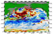 |
| Map of the North Pacific, showing the subtropical convergence zone as lines crossing its middle, taking on February 2003. The Northwestern Hawaiian Islands are on its path. (Photo: NOAA Coral Reef Ecosystem Division) |
As the seasons change, the subtropical convergence zone can be observed performing an annual dance in the North Pacific Ocean ballroom. When in the winter this line shifts south and passes the Northwestern Hawaiian Islands around January and February, the large, fractured atolls become a giant comb, trapping these floating debris from all around the North Pacific rim. During the summer, this convergence zone shifts north again.
The group charged with the removal of these pieces from these remote atolls and islands is the Marine Debris Project, part of the Coral Reef Ecosystem Division, under the NOAA Fisheries, Pacific Islands Fisheries Science Center. The group recently completed a large-scale project over the course of the last five years (which just ended in 2006) to remove as much of the derelict fishing gear in the Northwestern Hawaiian Islands as possible. Going out on missions stretching up to four months at a time, two liveaboard mother vessels would carry eight divers each.
After reaching a predetermined location, the Marine Debris Project has two methods for covering an area. In shallow reef areas, they snorkel, with the boat nearby. In deeper areas, they do “towboarding,” which involves a small board attached to the boat, which is running on average of between 1-2 knots. Inhaling deeply, and with a quick maneuver of the board, the free diver pairs can then go to the bottom, covering it in a serpentine fashion. Each diver covers a transect of 7.5 meters apiece, checking both sides of this transect while staying within visual range of the divers on either side. The distance among divers varies according to the visibility, but it’s never more than 15 cumulative meters, or approximately 45 feet, between the combined diver pair.
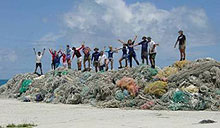 |
| A season’s worth of nets, recovered by the Marine Debris Project. (Photo: NOAA Coral Reef Ecosystem Division) |
To ensure that the whole swath is observed, divers take a daily visibility measurement by placing a small piece of net underwater, and determining from how far away this net can be seen. Surveys are then conducted, with a slight overlap among each swath to ensure full coverage. When derelict debris is found, they release the board, go to the surface, and raise their hand. At this point, the towing boat turns back, obtain latitude and longitude with a GPS unit, and help the diver retrieve the fishing gear.
One of the initial efforts undertaken in 1999 at Lisianski Island and Pearl & Hermes Atoll recovered 14 tons of derelict fishing gear. Most of this gear came from trawl netting, followed by mono-filament gillnet, and maritime line. This effort also showed this gear to affect the coral reef ecosystem of the Hawaiian Archipelago (Donnohue et al., 2001).
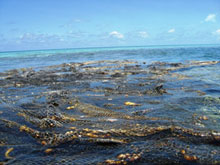 |
| A floating fishing net found at Pearl & Hermes Atoll in the Hawaiian Islands National Wildlife Refuge and NWHI Marine National Monument, stuck on top of a large coral colony. (Photo: Paulo Maurin) |
Since 2002, about 200,000 lbs of net have been recovered this way each year. Many of these pieces can be retrieved by one or two divers, but occasionally a particularly large net is found. One particular net had a weight in excess of 5,000 lbs, and took all divers working together to cut it into sections and pull it out of the water. Over the years, the group has found sharks, sea turtles and monk seals trapped in these nets. One even had a portion of a whale’s spine, apparently having caught the animal in the high seas.
The Marine Debris Project, having completed their focused clean up activities on the Northwestern Hawaiian Islands, has now entered into a maintenance phase. This will help them estimate the accumulation rates at repeated zones, which will allow them to determine the frequency of future clean up efforts, and the amount of funds needed. All of this to ensure that trash does not become constant stain in an otherwise vibrant and healthy environment.
References
Donohue, M., Boland, R.C., Sramek, C.M., Antonelis, G.A. (2001). Derelict fishing gear in the Northwestern Hawaiian Islands: Diving Surveys and Debris Removal in 1999 Confirm Threat to Coral Reef. Marine Pollution Bulletin, 42 (12), pg. 1301-1312.
|