|
Mission Log: June 26, 2006
Research Preparations While in Transit
Claire Johnson
NOAA National Marine Sanctuary Program
The transit from Honolulu, O`ahu to Kure Atoll, State Wildlife Refuge – the farthest reaches of the Northwestern Hawaiian Islands – continues for the crew and scientific party of the NOAA ship Hi’ialakai. As each day passes along the 1200-mile route, anticipation grows for all, particularly the people who haven’t been fortunate enough to visit this ocean wilderness in the past. Stories of previous adventures fill the mess hall during our meals, and every now and again you’ll walk past scientists or crewmembers swapping sea tales on the boat deck or in the dry lab. The excitement is unbearable and the preparations aboard the ship are never-ending.
 |
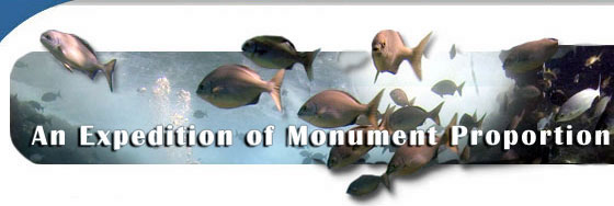
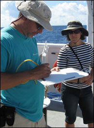
| Ship crew and the scientific party participate in an abandon ship drill, which occurs on every research cruise. (Photo: Claire Johnson/NOAA) |
After securing all the necessary permits from the United States Fish and Wildlife Service, State of Hawai`i Department of Land and Natural Resources, and the Northwestern Hawaiian Islands Marine National Monument managed by NOAA, we have all been approved, are on board and now underway. Once on the ship, there are abandon ship and fire drills, small boat training, emergency training, and many preparations for the research that will be taking place over the next 28 days. There are meetings to discuss the plan of the day, videos on biological protocols to land on Kure Atoll and much more to keep the scientific party busy during the long 6-day transit.
 |
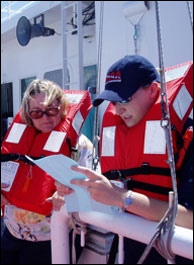
| A mock shipwreck survey takes place on the stern of the ship to demonstrate research techniques that will be used underwater. (Photo: Paulo Maurin) |
Short courses and slideshows on the shipwrecks that will be surveyed during this trip inform the educators and ship’s crew of the importance of preservation of these historical sites underwater. Hans Van Tilburg has shared the human stories behind the NW Hawaiian Islands shipwrecks, and photographs of interesting artifacts that have been discovered on past research cruises. Something fascinating that was news to our education team is that if we stumble across a pile of rocks while snorkeling or diving, it is likely ballast from a ship that was desperately trying to lighten their load before running aground on one of these remote atolls. There are no natural rocks found anywhere near the NW Hawaiian Islands, so the only explanation is ballast rocks.
Untouched wrecks in warm water dating back to 1822, such as the wrecks of the Pearl and Hermes whaling vessels make the NOAA Maritime Heritage team the envy of underwater archaeologists around the world. The team of underwater archaeologists, which are similar to underwater detectives, will be collecting data for interpretation of heritage resources through non-invasive site surveys.
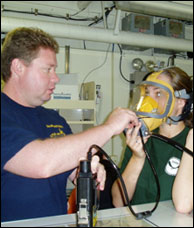 |
| The maritime heritage team dons agamasks in the dry lab to get practice in using their new underwater communication system. (Photo: Claire Johnson/NOAA) |
In the dry lab, the archaeologists discuss measured sketches, baseline trilateration analysis and test out all of their high-tech equipment. They don underwater aga-masks to test their primary underwater communications, as well as prepare all of the digital still and video camera gear for their first dives in a few days. Mid-morning on the back deck of the ship, the archaeology team conducts a mock shipwreck activity using baseline trilateration with the education team attentively observing their methods. This way, when the education team is snorkeling above the shipwreck site, we will be able to better interpret their survey techniques, having gone through a dry run on the Hi’ialakai’s back deck.
Mapping researchers have discussed the importance of use of multi-beam sonar and backscatter data to help characterize the seafloor. Why is this important you may ask? The data being collected on the seafloor and habitat is essential information to properly control a coral reef ecosystem using ecosystem-based management. Apparently less that 5% of the seafloor has been mapped in high resolution and in a region this ecologically important and biologically rich it is extremely vital to have a clear understanding of the NW Hawaiian Islands coral reef ecosystems.
 |
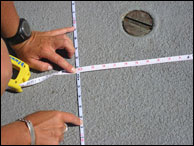
| Hans demonstrates baseline trilateration as the education team attentively observes. (Photo: Paulo Maurin) |
Already the mapping team has split into different shifts to begin the exhausting task of conducting mapping 24 hours a day once at Kure and Pearl and Hermes Atoll. Some members of the mapping team will work through the night “ground-truthing” seafloor videos to ensure that the dark gray color on their multi-beam bathymetric images is in fact coral reef habitat and the white sections are sandy bottom habitats. The research being conducted by this team comes from a Federal mandate to characterize all priority coral reef ecosystems by 2009. You can bet that the new Northwestern Hawaiian Islands Marine National Monument is a priority area for the State of Hawai`i, our country and even the world.
Once we arrive at Kure Atoll, the mapping team will be split into two groups, one team will stay aboard the NOAA ship Hi’ialakai and work the multi-beam sonar in deeper waters and another team of mappers will be launched on the small research vessel called Ahi to study the near-shore seafloor. This data will help fill in missing information from previous expeditions and can be used by all resource managers to better understand this ecologically valuable, remote wilderness.
Over the next few days of transit, I am sure the research preparations will continue. Gear will be tested again to ensure that not a moment is wasted when we are at our target locations to conduct the science. Conducting research in this remote location is challenging and opportunities to get out here are so few and far between that every moment on the ship needs to be taken advantage of.
|