|
Mission Log: June 29, 2006
Search and Survey at Kure Atoll
Kelly Gleason
Maritime Archaeologist
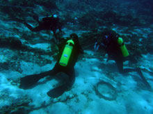 |
| Maritime archaeologists tag artifacts at a 19th century whaleship at Kure Atoll. (Photo: Brenda Altmeier) |
The Hi’ialakai arrived at Kure Atoll early this morning and the maritime archaeology team was ready to go with gear and tanks loaded on to the ship’s 10 meter jet boat, HI-1.
The team headed for their first target of the day, the site of the USS Saginaw located in 2003. The team decided to conduct one reconnaissance dive outside of the reef to locate more of the Saginaw site around the 30 foot contour.
Many of the sites maritime archaeologists investigate in the Northwestern Hawaiian Islands require this very simple kind of survey technique. The shipwrecks in this region are often the result of a collision with the treacherous reef, as is the case with the Saginaw, and sites are scattered for meters inside and outside of the reef crest. This exploratory dive did not produce any new information, however, and the team plans to continue dives in this area for the duration of our time working at Kure Atoll.
Following today’s survey outside of the reef near the Saginaw site, the team headed inside of the lagoon. The calm waters there allowed them to work for most of the day at a site thought to be the remains of the Parker, an American built whaleship lost in a severe storm at Kure Atoll in 1842.
 |
| Maritime archaeologists create a site map using data collected during dives at a 19th century whaleship at Kure Atoll. (Photo: Brenda Altmeier) |
The Parker site is scattered over 200 yards in the calm, clear and shallow waters of the lagoon inside of Kure Atoll. From the distribution of artifacts it appears that the storm lifted the entire bow section of this ship over the reef and into the lagoon, where it remains today.
The team began their survey of the site by laying a baseline from which they are able to measure artifacts and major features for the purposes of creating a detailed site map. Once the baseline was laid, and artifacts were numbered with tags, the six person maritime archaeology team split up into three teams of two divers, and mapped the site using a common technique called baseline trilateration.
The shallow site allowed the divers to work for several hours underwater, and the team collected a great deal of data over the course of two long dives on the site. The team returned to the Hi’ialakai in time to shower, eat dinner, and begin mapping the data collected during the day. A large table in the dry lab of the ship provided an ideal mapping table and the team rolled out graph paper and began plotting points and drawing the artifacts into a scaled drawing of the site.
The team ended the day by preparing gear for tomorrow’s day in the field. Plans to return to the Saginaw and Parker sites required prepping slates, tapes, dive gear and tanks for another day of work off of HI-1. This is a beautiful place to conduct maritime archaeological survey, and our work is helping to interpret the rich seafaring history of these remote atolls.
|