|
Mission Log: July 7, 2006
Site Maps and Whaling Ships at Pearl and Hermes Atoll
Kelly Gleason
Maritime Archaeologist
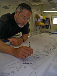 |
| Maritime Archaeologist Dr. Hans Van Tilburg puts the finishing touches on a site map of the whaling ship Parker, lost at
Kure Atoll. (Photo: Brenda Altmeier) |
During a day of transit to Midway Atoll, the maritime archaeology team began the final “inking” of their site plan for the whaling ship thought to be the Parker. After days of sketching in artifact measurements and distances taken at the shipwreck site in the lagoon at Kure Atoll, the team was ready to create a final product. All topography and details were completed and the team began the day by drawing the entire map in ink on a large sheet of vellum paper. This site map portrays the whaling ship lost at Kure Atoll in a new light. It is now a product for the team to share with the public to describe the artifact distribution and material culture remaining at this site the team is coming closer to fully understanding.
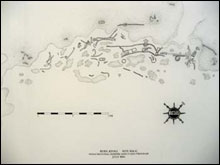 |
| The site map completed by the maritime archaeology team of the whaling ship Parker site at Kure Atoll. (Photo: Brenda Altmeier) |
Following the transit day to Midway, the team returned to Pearl and Hermes Atoll for a day of work at the whaling shipwreck sites Pearl and the Hermes, discovered in 2004 by the NOAA NMFS CRED during debris removal dives at the atoll. These two vessels were sailing in consort to in April of 1822 to the whaling grounds discovered in Japan in 1820. At this time, the Northwestern Hawaiian Islands were not on any charts, and so the ill-fated ships did not realize the hazards that lay between the main Hawaiian Islands and the whaling grounds. According to a letter written by the carpenter of the Hermes, James Robinson, the Hermes wrecked first, and the Pearl wrecked to the east after trying to render assistance.
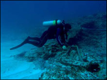 |
| Maritime archaeologist Tane Casserley documents the whaling ship Pearl at Pearl and Hermes Atoll. (Photo: Brenda Altmeier) |
Pocillopora meandrina). Before I got close enough to scare them all away, there were approximately 45 Hawaiian domino damselfish (Dascyllus albisella
Today, the team headed to the site of the Pearl. This site is beautiful, located in a surge channel outside of the reef where trypots, anchors, cannon, and various other artifacts are scattered. It was remarkable to notice how much the site has changed since the last time that the team visited the site in May of 2005. Upon arrival at the site this morning, the maritime archaeology team noticed several new artifacts revealed by the movement of sand off of the site. A grinding wheel, entire cannon, ballast, as well as extensive amounts of copper sheathing have been revealed.
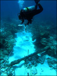 |
| Maritime Archaeologist Lindsey Thomas sketches artifacts at the whaling ship Pearl at Pearl and Hermes Atoll. (Photo: Brenda Altmeier) |
There are four trypots at this site, and it is impressive to notice the way that the trypots are all lying on layers of the copper sheathing, as if the trypots sank to the seafloor just as they lay in the vessel. The timbers of the ship have, for the most part, disappeared due to the dynamic saltwater environment. A few, however, still remain, most likely the keel and garboard strakes. The team’s tasks included laying a baseline, and tagging artifacts to be sketched in reference to the datum so that the team will be able to create another site map. Shipwreck sites take weeks and sometimes longer to document and interpret. The limited amount of time the team is able to spend on these remote sites is precious, and they have been lucky to have good weather, and many days of safe and productive dives. This time in the field yields a large amount of data for site maps, reports and presentations to the public.
|