Smelly Gas Helps Researchers Track Right Whales
By Rachel Plunkett
March 2024
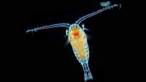
In the vast open ocean, how does a large animal like a right whale find enough food to eat? Right whales eat copepods, a tiny marine zooplankton, and the copepods eat microscopic plants known as phytoplankton. Scientists suspect that in order to find food, the whales are following odors produced by natural chemical compounds. The compound scientists are most interested in is called dimethyl sulfide (DMS) — a smelly gas released when the copepods eat phytoplankton. Essentially, in order to predict where the North Atlantic right whales will be aggregating, scientists are following the same scent trail the whales may be using to locate their favorite food.
Using Science to Improve Management
Why does all this matter? Because North Atlantic right whales are critically endangered and at risk of extinction. By the early 1890s, commercial whalers had hunted North Atlantic right whales to the brink of extinction. While whaling is no longer a threat and right whales have federal protections, they never recovered to their pre-whaling numbers. Scientists estimate fewer than 360 North Atlantic right whales remain in the ocean, including less than 70 breeding females. Accidental entanglement in fishing gear and vessel strikes account for most documented right whale deaths. In order to better protect whales from these threats, researchers need to be able to predict their movements.
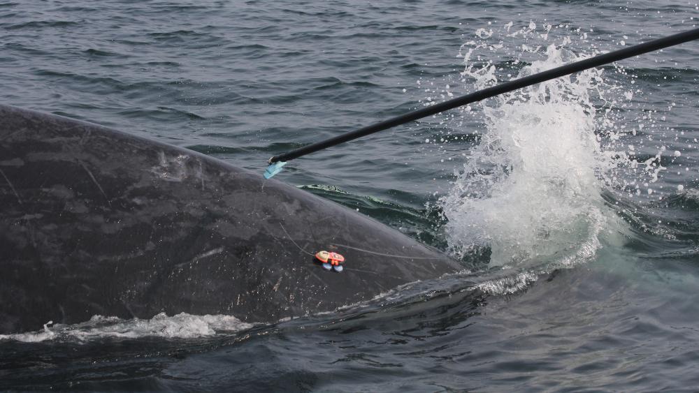
The problem with relying solely on traditional whale tagging methods to understand everything researchers need to know about their movements in feeding grounds is that the non-invasive suction cup tags usually fall off, and other more invasive tagging methods can cause infection and other harm to the animals. Tracking the whales’ food source instead of the whales themselves could eventually be a more reliable method, and is also much less invasive to the endangered animals.
The Stereo-Smell Hypothesis
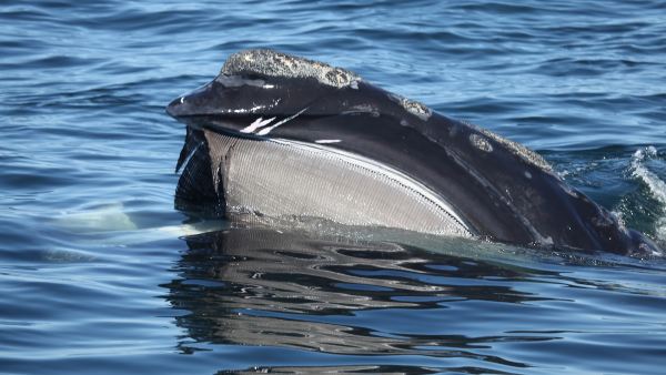
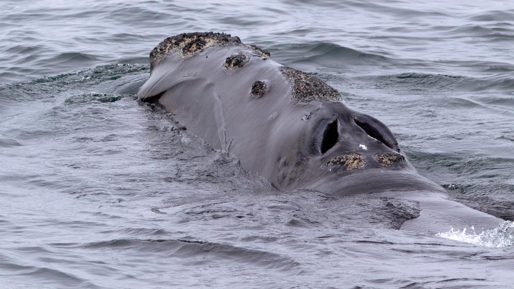
Support for the hypothesis that right whales are using DMS to home in on their food lies in the anatomy of the whales themselves. Baleen whales, such as right whales, have paired blowholes (called “nares”), while toothed whales have just one. A recent study found that subtle physical differences may provide right whales with an olfactory advantage over other baleen whales.
Similar to how the widely separated eyes (stereo vision) of the praying mantis help it judge distance from prey and improve its hunting ability, or how the asymmetrical ears on either side of an owl’s head help it pinpoint the precise source of a sound — the larger gap observed between the nares of the right whale’s blowhole (stereo smell) might help point it in the direction of a smell emitted by its food. The right whale stereo-smell hypothesis makes the case for tracking the smelly gas, DMS, to locate the whales more appealing.
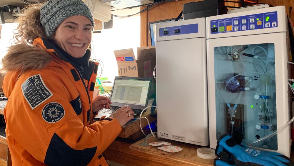
Last year, researchers from Stellwagen Bank National Marine Sanctuary, Woods Hole Oceanographic Institution, and International Fund for Animal Welfare followed right whales in Cape Cod Bay and collected water samples to measure the amount of DMS in the water where they are feeding. “What we found out is that lots of copepods create lots of dimethyl sulfide, which makes it a very attractive place for right whales to go and eat,” said Dave Wiley, research ecologist at Stellwagen Bank National Marine Sanctuary. “The right whales are showing up in areas with the highest DMS concentrations.”
2024 Field Season
The research team is back out in Cape Cod Bay. This year, their goals are to determine if it’s possible to find the lowest level of DMS (threshold) that might forecast when right whales will be around, and to combine information about the concentration of DMS in the water with behavioral data from tagging, as well as tracking the whales.
“We know the whales are here to feed, and we know they go where their food is. We still haven’t figured out, though, how they find areas with a high density of food,” said Daniel Zitterbart, associate scientist at Woods Hole Oceanographic Institution. “Once we can confirm if they are actively feeding in areas with high DMS concentrations, then we can say with greater confidence that DMS might be a reliable way to track right whales.”
Predicting where whales are feeding could help to better manage human activity around the whales by slowing vessels down or routing them around these areas, as well as pulling up fishing gear.
“We want to protect right whales to the best of our ability without restricting human activity in the area. The best way to do that is with good information,” said Wiley. Currently Stellwagen Bank National Marine Sanctuary communicates information about whale sightings to boaters and mariners in the area using WhaleAlert. The app allows anyone on the water to share sightings to help rescuers, researchers, and mariners reduce deadly vessel strikes. The sanctuary also recently had success testing a text message system to communicate directly with vessels on the water about right whale activity and vessel speed limits using Automated Identification System (AIS).
Satellite Tracking
The part of this year’s work that involves attempting to establish a DMS threshold to predict when right whales are likely to move into or out of an area will help with future remote sensing. The ultimate goal is to move away from relying only on visual sightings and acoustic sensors and figure out how to remotely detect where the copepods and whales are by generating color-coded heat maps of DMS through satellite technology. If this new tool can be developed, it would eventually allow researchers to track the food source of right whales in near real time to better predict their movements.
It’s already possible to track where the phytoplankton are in real time using heat maps of chlorophyll. Imagine a chlorophyll heat map as a colorful picture that shows where plants and algae are most active and healthy. Chlorophyll is a green pigment in plants that helps them turn sunlight into energy through a process called photosynthesis. In a chlorophyll heat map, different colors represent different levels of chlorophyll activity. The areas with more intense colors indicate higher levels of chlorophyll, suggesting that plants or phytoplankton in those areas are thriving.
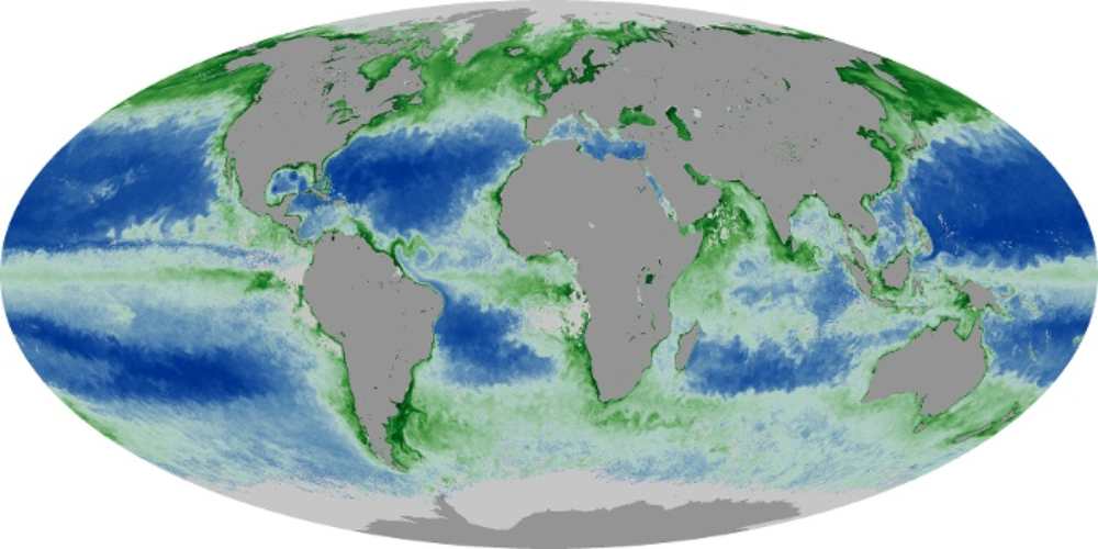
“We can’t really rely on chlorophyll maps to track North Atlantic right whales, however, because there is a variable lag in time between when we see the phytoplankton blooming and when the zooplankton show up to eat the phytoplankton and the whales show up to eat the zooplankton,” explains Wiley.
Just like the pigment chlorophyll is an indicator used for remotely mapping phytoplankton, DMS is one possible indicator for creating similar maps of zooplankton. “Creating heat maps of DMS will give a more accurate picture of when the right whale’s food source — copepods — are in the area.” A team at NASA is also looking at another possible method for the remote sensing of Calanus copepods that involves a pigment called astaxanthin.
What About Climate Change?
This ability to track right whales in near real time without disturbing them is important with regard to human-caused climate change, which is already having an impact on the movement of species around the world. Right now, Stellwagen Bank National Marine Sanctuary is at the southern range of where the copepods that right whales love to eat are found. Over the last decade or so, right whale spring/summer foraging grounds have shifted north from the Gulf of Maine and the western Scotian Shelf all the way to the Gulf of St. Lawrence in Canada.
“This means climate change is already affecting their ranges, because they are following their food sources further north,” Wiley explains.
As North Atlantic right whales' foraging grounds have shifted further north, their exposure to risks such as ship strikes and entanglement has increased despite many ongoing efforts to protect them. As climate change continues to throw more curve balls into the picture, it will be easier for managing agencies to work together to ensure the endangered whales’ protection if they know more accurately where they are throughout the year.
If researchers can figure out how to track right whales using remote sensing of DMS, it will be a game-changer for understanding how climate change is altering their access to important feeding habitats.
EARTH IS BLUE VIDEO: NORTH ATLANTIC RIGHT WHALES
Beyond Right Whales
The ability to map DMS will also provide useful data for ocean energy practitioners. "The Bureau of Ocean Energy Management cares greatly about protecting right whales from ship strikes in the best ways possible," said Jacob Levenson, marine biologist at BOEM. "Having a system that informs everyone of high areas of DMS (and presumably right whale activity) would be a great tool to support the protection of North Atlantic right whales and the responsible development of offshore wind energy."
Beyond right whales, other marine animals such as albatross and sea turtles are being studied for their ability to use DMS to locate productive feeding grounds in the ocean. Remotely sensing and monitoring DMS could also help scientists understand how climate change is impacting ocean productivity at a variety of scales, and the implications for other food chains.
Rachel Plunkett is the content manager and senior writer at NOAA’s Office of National Marine Sanctuaries.