The Underwater World of Living Shipwrecks
By Shannon Ricles
November 2020
Explore North Carolina shipwrecks and the marine life that inhabit them in 3D with NOAA’s new website: Living Shipwrecks 3D. This work not only honors the sacrifices of our Allied seamen and the heroism of the U.S. Merchant Marine, but also recognizes the role these shipwrecks play today in the region’s health as habitat for vibrant and thriving marine ecosystems.
Exploring Beneath the Surface
Do you often wonder what lies on the ocean floor? Or where fish and other sea life live? In a collaborative research project between the National Centers for Coastal Ocean Science and Monitor National Marine Sanctuary, scientists have worked to answer these questions and more using cutting edge technology to explore under the ocean’s surface.
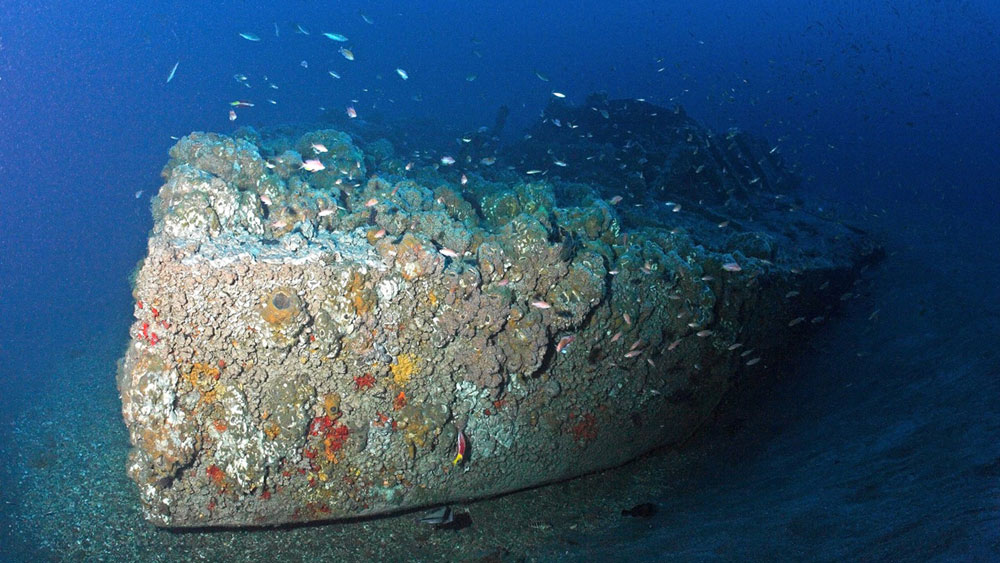
Off the North Carolina coast lie scores of ships that sank during the Civil War, World War I, and World War II. Since 2008, Monitor National Marine Sanctuary and partners have studied and documented these historically significant shipwrecks that serve as quiet witnesses to the valor and sacrifices of generations past.
Today, these shipwrecks not only represent our nation’s rich maritime history, but they serve as artificial habitat for a diversity of marine life. They are home to important fish populations, and researchers with the National Centers for Coastal Ocean Science work to document how and when fish use these artificial structures. This collective work is now featured in a new website, Living Shipwrecks 3D, where you can explore wartime shipwrecks, as well as the fish that surround them.
The Research
High resolution image of W.E. Hutton, and the fish living on it. Fish school extent is displayed via white dots and was detected by an instrument called a multibeam echosounder. Image: NOAA, NCCOS/MNMS
With our nation’s long tradition of honoring and protecting special places that have defined our history, this research serves to commemorate and honor the men who fought and died off the North Carolina coast in defense of freedom. During World War II, the area off Cape Hatteras, North Carolina, emerged as a strategic hotspot for German U-boat activity. This activity resulted in a collection of shipwrecks unparalleled in the United States consisting of 78 merchant ships, eight Allied warships, and four German U-boats. These shipwrecks serve as gravesites for nearly 1,700 individuals and as a memorial to this history, particularly to the sacrifice of the U.S. Merchant Marine.
Since their sinking, these shipwrecks now provide habitat for an abundance of marine life. Like natural reefs, artificial reefs provide structure and homes for a diversity of important fish species. The reefs along the United States’ southeastern continental shelf consist of naturally-occurring rocky reefs, intentionally-sunk artificial reefs, and shipwrecks. This collection of reefs hosts a wide assortment of fishes, including tropical, subtropical, and temperate species. Understanding how fish communities use these habitats can help researchers ensure that the reef ecosystems remain sustainable in support of the blue economy.
Technology Used and Products Created
Fish visualization of HMT Bedfordshire. The British convoy escort vessel sank with all hands on May 12, 1942, when attacked by the German U-boat, U-558. Image: NOAA, NCCOS/MNMS
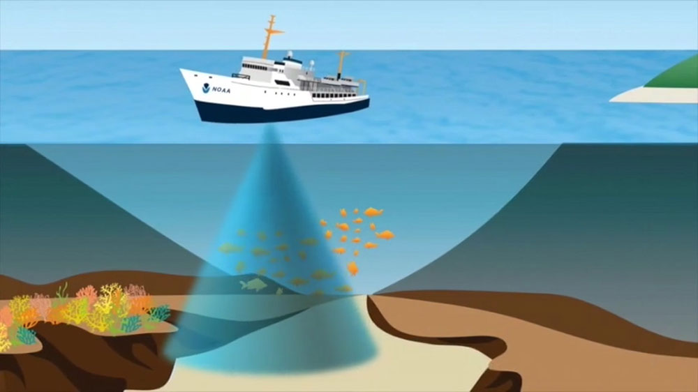
To better understand how these shipwrecks function as artificial habitats, scientists collect data using visual and acoustic methods, including high-resolution seafloor habitat mapping and surveys using echosounders (splitbeam and multibeam), remotely operated vehicles, time-lapse video, and scientific diving.
The documentation of these shipwrecks enables maritime archaeologists to more closely examine this World War II battlefield, as well as the many other shipwrecks from World War I and other time periods. The data collected gives researchers detailed and accurate 3D imaging of the shipwrecks, often giving new insights into the ships and how they sank. The research also aids maritime archaeologists in drawing accurate site plans, creating photomosaics and dive slates, documenting artifacts, and offering beautiful underwater images of the wrecks. Today, many of these shipwrecks are popular recreational dive sites and the products that NOAA produces are beneficial to divers, giving them information about the shipwreck, as well as a better understanding of the wreck’s historical significance, and why it is necessary to protect these important historical sites.
Once collected, the data are also synthesized into maps and visualizations to test hypotheses on how shipwrecks provide habitat for a variety of species. Scientists seek to answer questions about the characteristics of reef habitat, how shipwrecks and natural reefs differ, and which large predators use these reef types. The research also demonstrates that artificial reefs fill key ecological roles, such as hosting an abundance of reef fish, supporting large predators, and facilitating tropical fishes at the edges of their northern and cold water range.
New Interactive Website
Multibeam survey of the World War II tanker, Ashkhabad that sank on April 30, 1942, when torpedoed by German U-boat U-402. Image: NOAA Ship Nancy Foster, 2016
The Living Shipwrecks 3D website is a compilation of data collected over four years of NOAA missions in and around Monitor National Marine Sanctuary. The website is an interactive tool that brings North Carolina’s World War II battlefield to your computer or even your tablet or phone. Users can learn about the science behind how NOAA maps shipwrecks and fish, and they can browse these wrecks to learn about their historical significance, view underwater photographs and sonar images, and use a data viewer to explore 3D maps of the shipwrecks and associated fish communities.
The partnership and collaborative research between the National Centers for Coastal Ocean Science and Monitor National Marine Sanctuary made the website possible. The research not only honors the sacrifices of our Allied seamen and the heroism of the U.S. Merchant Marine, but also recognizes the role these shipwrecks play today in the region’s health as habitat for vibrant and thriving marine ecosystems.
Shannon Ricles is the education and outreach coordinator for Monitor National Marine Sanctuary.