Ocean Exploration Trust 2021 Expedition
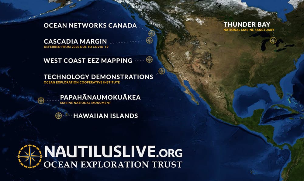
This spring and fall, NOAA's Office of National Marine Sanctuaries is teaming up with Ocean Exploration Trust to explore the marine ecosystems of Thunder Bay National Marine Sanctuary in Michigan and Papahānaumokuākea Marine National Monument in Hawaii.
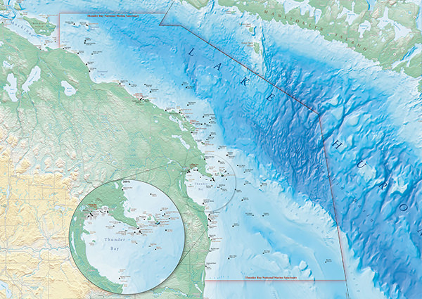
In June, Thunder Bay National Marine Sanctuary and Ocean Exploration Trust will use cutting-edge technology to explore Lake Huron. A mapping project using autonomous surface vehicle (ASV) BEN will support ongoing exploration and management of Thunder Bay National Marine Sanctuary's maritime heritage sites. Survey information and products will support exploration and management of the only freshwater national marine sanctuary in the United States, and will provide new and important information for archaeologists, biologists, and geologists. This follows a successful survey of 59 square miles of sanctuary bottomlands in 2019.
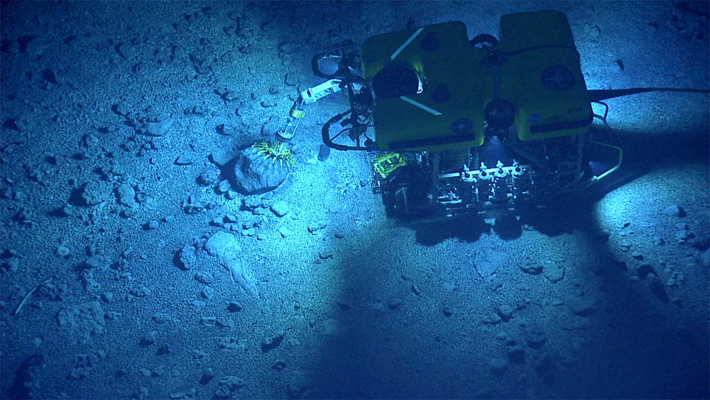
Throughout the fall, researchers will conduct mapping operations and use remotely operated vehicles (ROVs) to investigate seamounts in Papahānaumokuākea Marine National Monument. You can watch live streamed ROV footage from the expedition on NautilusLive.org.
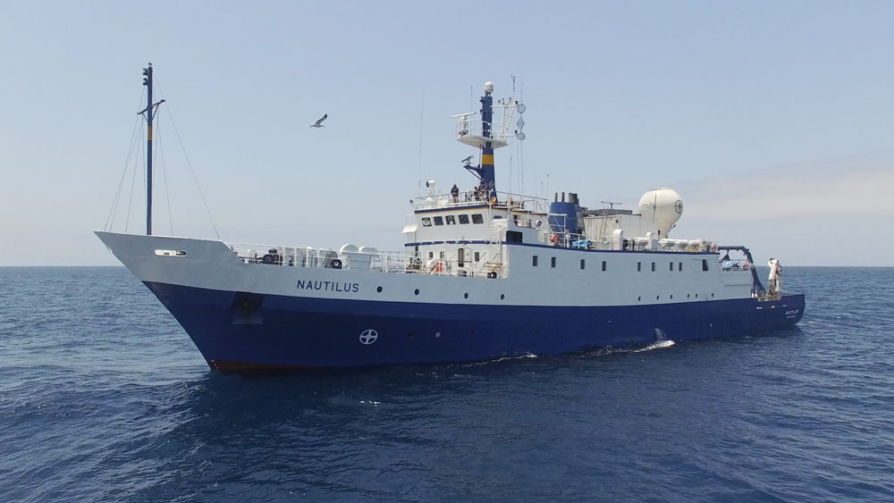
NOAA Ocean Exploration provides additional support for the ocean exploration program of the E/V Nautilus, which operates under a similar paradigm as the NOAA Ship Okeanos Explorer.
The E/V Nautilus is equipped with telepresence, which allows scientists from around the world to participate in and contribute to the success of this mission. Plus, telepresence brings the National Marine Sanctuary System and ocean science to the classroom, as students across the country directly engage with mission staff and operations.
For a full run-down of Ocean Exploration Trust's 2021 expedition plan and to watch live video, visit NautilusLive.org. Read on for details on the expedition's voyages into your national marine sanctuaries.
You can follow the expedition on the NOAA Office of National Marine Sanctuaries social media channels, and check back here for updates, photos, and video as the expedition continues.
Exploring Ancient Volcanoes in Papahānaumokuākea Marine National Monument I: First Mapping of the Liliʻuokalani Seamounts
Dates: October 24–November 13, 2021
Expedition leader: Dr. Emil Petruncio, Ocean Exploration Trust
Lead scientist: Dr. Christopher Kelley, University of Hawaiʻi
Area of Exploration: Papahānaumokuākea Marine National Monument
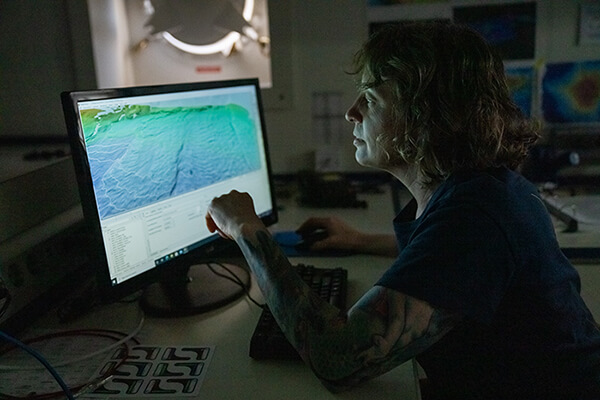
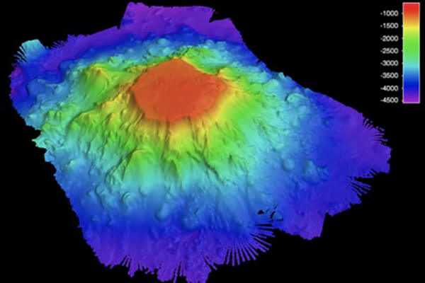
This 21-day expedition will involve multibeam and sub-bottom profiler mapping on the unmapped and unexplored Liliʻuokalani Seamounts located in Papahānaumokuākea Marine National Monument (PMNM). Mapping is a prerequisite form of seamount for remotely operated vehicle (ROV) dives in future expeditions, since it provides detailed visualization of the targeted features.
The monument encompasses 582,578 square miles of the Pacific Ocean, an area larger than all the United States’ national parks combined, and is one of the largest marine conservation areas in the world.
Since scientific exploration has not been conducted in this region, the seamounts must first be mapped to provide detailed visualization of underwater features. Information collected during this expedition will help to determine summit depths and pinpoint future dive sites for the science team when they conduct ROV dives at Liliʻuokalani Seamounts in 2022. Satellite and nautical chart data suggest that at least two seamounts in this area reach surprisingly shallow depths, given their assumed Cretaceous origin between 66 and 145 million years ago.
As we visit Papahānaumokuākea, the ancestral homeland of the Native Hawaiian people and the largest marine conservation area in the U.S., we gratefully acknowledge generations of Indigenous Hawaiians and today’s stewards of these waters. Ocean Exploration Trust is working closely with PMNM collaborators to inform research priorities at sea and from shore, ensure culturally-grounded collection protocols, and connect with local communities through ship-to-shore connections, a virtual role model speaker series, and development of education resources in ‘Ōlelo Hawaiʻi (Hawaiian language). All of these efforts support opportunities to work with Native Hawaiians and to perpetuate the cultural values, knowledge, and practices of their cultural heritage while advancing modern science and exploration together.
This expedition is sponsored by NOAA Ocean Exploration through the Ocean Exploration Cooperative Institute and the National Oceanographic Partnership Program.
Find out more at NautilusLive!
Exploring Ancient Volcanoes in Papahānaumokuākea Marine National Monument II: Southern Wentworth Seamounts
Dates: November 15–December 6, 2021
Lead scientists: Dr. Christopher Kelley, University of Hawaiʻi, Dr. Randall Kosaki, Papahānaumokuākea Marine National Monument, Dr. Beth Orcutt, Bigelow Laboratory for Ocean Sciences
Expedition leader: Dr. Emil Petruncio, Ocean Exploration Trust
Area of Exploration: Papahānaumokuākea Marine National Monument
This 23-day expedition will involve mapping and ROV dives on unexplored seamounts located in Papahānaumokuākea Marine National Monument. Scientists will survey seamounts, document biological communities, and collect rock samples, specimens, and water samples. Follow along on NautilusLive.org.
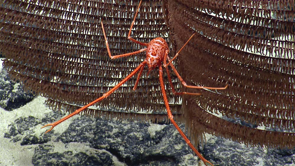
The target region within PMNM, which has never been explored by ROV, may encompass the previously unrecognized southernmost extent of the Wentworth Seamounts, a small chain of Cretaceous "hotspot" or "mid-plate" volcanoes created between 66 and 145 million years ago.
Scientists will be looking for high-density coral and sponge communities as well as working to identify potentially new-to-science macro-biological (large) specimens. They will be collecting rock samples to help unlock the origins of these seamounts.
Understanding and protecting natural ecosystems is a primary goal of PMNM. While marine species from shallow waters are relatively well surveyed, the biological communities from the deeper seamounts are largely unexplored. Like shallow coral reefs, these habitats represent hot-spots of biological diversity that require a deeper understanding for future conservation and exploration efforts.
As we visit Papahānaumokuākea, the ancestral homeland of the Native Hawaiian people and the largest marine conservation area in the U.S., we gratefully acknowledge generations of Indigenous Hawaiians and today’s stewards of these waters. Ocean Exploration Trust is working closely with PMNM collaborators to inform research priorities at sea and from shore, ensure culturally-grounded collection protocols, and connect with local communities through ship-to-shore connections, a virtual role model speaker series, and development of education resources in ‘Ōlelo Hawaiʻi (Hawaiian language). All of these efforts support opportunities to work with Native Hawaiians and to perpetuate the cultural values, knowledge, and practices of their cultural heritage while advancing modern science and exploration together.
This expedition is sponsored by NOAA Ocean Exploration through the Ocean Exploration Cooperative Institute and NOAA’s Office of National Marine Sanctuaries.
Follow along at NautilusLive!
Thunder Bay National Marine Sanctuary: Viewing the Lakebed with Robotic "Eyes"
Dates: June 7–25, 2021
Expedition leader: Dwight Coleman, Ocean Exploration Trust
Lead scientists: Stephanie Gandulla, Thunder Bay National Marine Sanctuary, Jeff Gray, Thunder Bay National Marine Sanctuary
ASV Team Leader: Val Schmidt, Center for Coastal and Ocean Mapping, UNH
Area of Exploration: Thunder Bay National Marine Sanctuary, Michigan
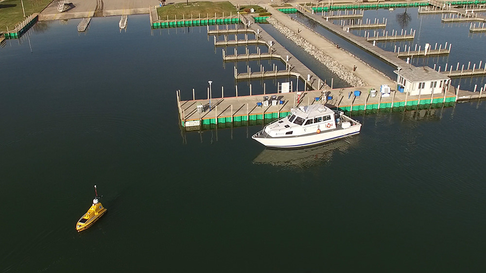
NOAA's R/V Storm waits for ASV BEN to leave the Rogers City marina to start mapping operations in Lake Huron during the 2019 expedition. Photo: David Cummins/Alpena Community College
Located in Lake Huron, NOAA's Thunder Bay National Marine Sanctuary (TBNMS) was established in 2000 to protect one of the nation's most historically significant collections of shipwrecks. Encompassing 4,300 square miles, TBNMS is the nation's largest marine protected area focused on underwater cultural heritage sites. Within this new boundary are 99 known shipwreck sites, while historical research indicates as many 100 additional sites in the area remain undiscovered.
This project augments 2019's successful survey of 59 square miles of sanctuary bottomlands. It will continue to map priority areas of TBNMS with multibeam sonar using the research ASV BEN from the University of New Hampshire's Center for Coastal and Ocean Mapping. BEN is a small, self-driving boat that uses multibeam sonar to learn more about what's on the lake floor. Sonar works by sending sound waves through the water, then measuring the amount of time that sound takes to "echo" off the bottom. The shorter the time it takes for sound to bounce back to BEN, the closer an object is to the surface. BEN is able to translate this information into images of the lakebed that researchers can use to pinpoint natural features like sinkholes and cultural features like historic shipwrecks.
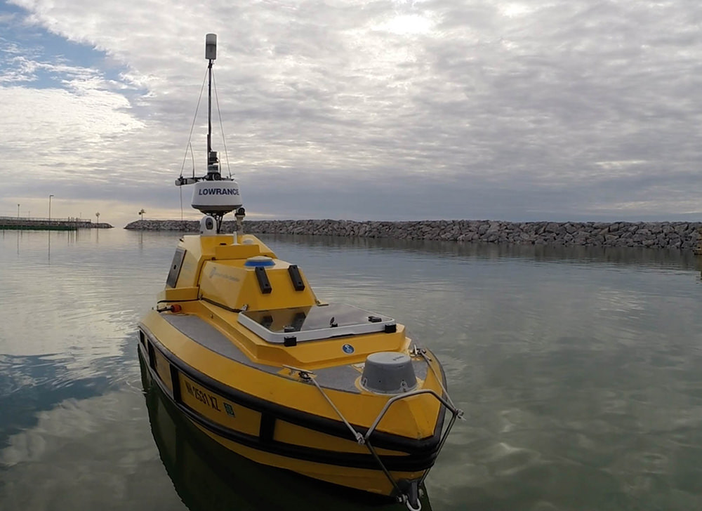
ASV BEN (Bathymetric Explorer and Navigator) is a custom prototype built by SV Global Unmanned Marine System for University of New Hampshire's Center for Coastal and Ocean Mapping. ASV BEN has a state-of-the art seafloor mapping system that can map depths reaching 650 feet. Photo: Ocean Exploration Trust
Survey information and products from this expedition will support exploration and management of the only freshwater national marine sanctuary in the United States and will provide new and important information for archaeologists, biologists, and geologists. Data can also be used to produce benthic/lakefloor habitat maps for managing the condition of Lake Huron's ecosystems, and for navigational charts.
The public is invited to join this exciting expedition through virtual programming. Tune in to Thunder Bay National Marine Sanctuary and NOAA Office of National Marine Sanctuaries social media channels to learn more about opportunities to tune in to live broadcasts.
Educational Resources
Lesson Plans
Explore the Blue: 360 degrees Shipwreck Alley
Virtual Dive Activity Sheets: Thunder Bay National Marine Sanctuary
Preservation Through Education: Activities & Programs: Mock Shipwreck Lesson Plan
Nautilus Live Maritime history (archeology) Education Resources
NOAA Ocean Exploration: Marine Archaeology - essays, lessons, multimedia, and more