State of Sanctuary Resources
Click on the following links to access the three Monterey Bay National Marine Sanctuary State of Sanctuary Resources
Offshore Environment | Nearshore Environment | Estuarine Environment
This section provides summaries of the condition and trends within four resource areas: water, habitat, living resources and maritime archaeological resources. Sanctuary staff and selected outside experts considered a series of questions about each resource area. The set of questions is derived from the mission of the Office of National Marine Sanctuaries, and a system-wide monitoring framework (NMSP 2004) developed to ensure the timely flow of data and information to those responsible for managing and protecting resources in the ocean and coastal zone, and to those that use, depend on, and study the ecosystems encompassed by the sanctuaries. Appendix A (Rating Scheme for System-Wide Monitoring Questions) clarifies the set of questions and presents statements that were used to judge the status and assign a corresponding color code on a scale from Good to Poor. These statements are customized for each question. In addition, the following options are available for all questions: “N/A” – the question does not apply; and “undetermined” – resource status is undetermined. In addition, symbols are used to indicate trends: “ ▲” – conditions appear to be improving; “▬” – conditions do not appear to be changing; “ ▼” – conditions appear to be declining; and “?” – the trend is undetermined.
This section of the report provides answers to the set of questions. Answers are supported by specific examples of data, investigations, monitoring, and observations, and the basis for judgment is provided in the text and summarized in the table for each resource area. Where published or additional information exists, the reader is provided with appropriate references and web links.
Judging an ecosystem as having "integrity" implies the relative wholeness of ecosystem structure and function, along with the spatial and temporal variability inherent in these characteristics, as determined by the ecosystem's natural evolutionary history. Ecosystem integrity is reflected in the system's ability to produce and maintain adaptive biotic elements. Fluctuations of a system's natural characteristics, including abiotic drivers, biotic composition, complex relationships, and functional processes and redundancies are unaltered and are either likely to persist or be regained following natural disturbance.
Questions 4, 8, 14, and 17 examine the levels of human activities that may influence resources in the sanctuary. While each question has received a status and trend rating and an associated basis for judgment explanation, it should be noted that trend data are lacking for many of the human acitivites that were considered. In addition, the relationship between impacts resulting from an increased population in the area with the various management and educational efforts that are designed to mitigate the impacts of anthropogenic pressures was difficult to assess.
Because of the considerable differences within the sanctuary between offshore, nearshore, and estuarine environments, each question was answered separately for each of these environments.
Offshore Environment
Offshore Environment Water Quality
The following information provides an assessment of the status and trends pertaining to water quality in the offshore environment.
1. Are specific or multiple stressors, including changing oceanographic and atmospheric conditions, affecting water quality and how are they changing?
Stressors on water quality in the offshore environment, specifically persistent organic pollutants (POPs), fluctuations in nutrient levels, and changing ocean conditions, may inhibit the development of assemblages and may cause measurable declines in living resources and habitats. For this reason the rating for this question is "fair" with a "declining" trend. Offshore waters have shown elevated levels of contaminants (CCLEAN 2007), ocean temperature and chemistry changes (MBARI 2006), some of which have been linked to changes in the offshore ecosystem (Tanner 2006).
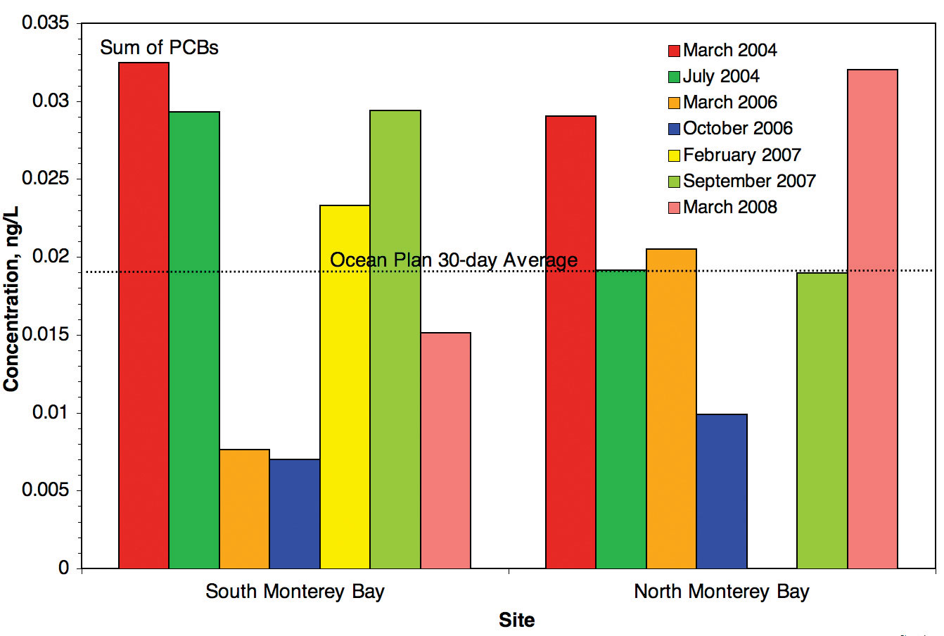
Certain POPs, including polycyclic aromatic hydrocarbons (PAHs) and polychlorinated biphenyls (PCBs), have exceeded California Ocean Plan objectives (CCLEAN 2007). Monitoring data indicates the majority of POP and some nutrient (nitrate and urea) loading are mostly due to inputs from large rivers such as the Salinas, Pajaro, San Lorenzo, and Carmel and that orthophosphate and urea loads from these rivers have been increasing during recent years (CCLEAN 2007). Hartwell (2008) analyzed sediment samples and concluded that Monterey Bay watersheds are the primary source of DDT for an expanse of the Central California continental shelf that includes San Francisco Bay. Water samples collected by the CCLEAN program show that sites approximately five miles offshore in northern and southern Monterey Bay exceed the Ocean Plan water quality standards for polychlorinated biphenyls (PCBs) (Figure 28) and dieldrin (a persistent, bioaccumulative, toxic insecticide that was used from 1950 to 1974). Contaminants in sediment samples (which may indicate potential problems in the water column) do not exceed NOAA persistent organic pollutant (POP) alert levels. However, concentrations of the legacy pesticides DDT and dieldrin frequently exceed the NOAA Effect Range Low (ERL) guideline at which amphipod toxicity is typically measured in 10% of laboratory bioassays (CCLEAN 2007, 2009). Moreover, DDT concentrations are relatively higher in these offshore locations than the average concentrations measured in San Francisco Bay and have not declined at most locations since the 1970s (CCLEAN 2007). Concentrations of dieldrin exceeded the ERL in 22 out of 40 samples collected from 2005 to 2006 (CCLEAN 2007).
While the overall ecological effects of stressors are difficult to measure because they are the result of complex interactions among biological and environmental factors, there is recent evidence of the deleterious effects of POPs in the marine environment. CCLEAN (2007) has found that suspended sediment from rivers, primarily the Pajaro River, may have negative effects on benthic organisms along the 80-meter contour. Moreover, the cumulative concentrations of POPs were associated with decreased abundance of some benthic infauna. Preliminary work from Miller et al. (2007) showed that southern sea otters with moderate or high exposure to freshwater flows had significantly higher concentrations of certain POPs (DDDs, DDE, HCH delta, dibenzothiophene C2 and PBDE 017) compared to those that came from areas with low exposure to freshwater flows. This study also suggests that some POPs may contribute to the risk of sea otter death due to infectious agents and trauma.
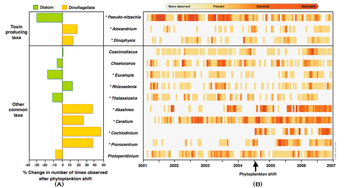
Oceanographic monitoring data collected by the Monterey Bay Aquarium Research Institute (MBARI) shows that since 1999 there has been a regime shift from warmer to cooler water conditions and that nitrate levels at 60 meters have been above normal (MBARI 2006). The taxonomic structure of the offshore phytoplankton community in Monterey Bay shifted during the summer of 2004 from the typically diatom-dominated community to a red-tide, dinoflagellate-dominated community and was associated with the presence of toxins in higher trophic level species (Jester 2008) (Figure 29). Since the taxonomic structure of the phytoplankton community affects how these toxins move through local food webs, the shift in this community is likely to have affected fish and higher trophic level organisms in ways that are important for the ecosystem both ecologically and commercially (MBARI 2006). The shift is possibly related to changes in water mass, nutrient levels, water column structure, or other environmental phenomena (Tanner 2006).
2. What is the eutrophic condition of sanctuary waters and how is it changing?
The offshore environment is rated "good/fair" relative to this question because monitoring data suggests that selected conditions may preclude full development of living resource assemblages and habitats, but are not likely to cause substantial or persistent declines. A "declining" trend is supported by evidence of nutrient enrichment, increasing nutrient loading, and increasing frequency and intensity of harmful algal blooms in selected areas of the offshore environment. In this context, eutrophication refers to the human accelerated process of organic enrichment of water bodies that can lead to hypoxia and anoxia, habitat degradation, alteration of food-web structure, loss of biodiversity, and alteration of harmful algal bloom (HAB) dynamics (Howarth 2008). Humans could be influencing algal blooms by increasing nutrient availability via runoff, causing climate change, or by assisting in the transport of new species into an area (Gilbert et al. 2005, CIMT 2006). Human-derived runoff, sewage, and fertilizers may be interacting with increased sea surface temperatures to alter the natural pattern of algal blooms.
HAB dynamics in California appear to be dominated by large-scale oceanographic forcing of nutrient dynamics (Anderson et al. 2008, Kudela et al., 2005, Kudela et al., 2004), however, there is growing evidence to suggest that the spatial extent, duration, and toxicity of events can be influenced by anthropogenic nutrient inputs. While evidence for direct causative links between HABs and coastal runoff and/ or eutrophication are lacking, there is abundant correlative evidence within Monterey Bay and in other areas of California (Anderson et al. 2008). Strong linkages have been demonstrated between nutrient enrichment and phytoplankton production in estuarine and marine waters for a wide range of geographic scales (Nixon 1992, Mallin et al. 1993). Scholin et al. (2000) provided indirect evidence that a massive HAB event in Monterey Bay was triggered by post-El Niño runoff. Domoic acid production by Psuedo-nitzchia species has been shown to be responsive to inputs from coastal watersheds including copper (Ladizinsky 2003) and urea (Howard et al. 2006). Toxic HAB species (Pseudo-nitzchia and Alexandrium catenella) may use dissolved organic nitrogen forms such as urea, which has been measured at substantial concentrations in nearshore waters and is likely derived from anthropogenic sources (Cochlan et al. 2008, Anderson et al. 2008).
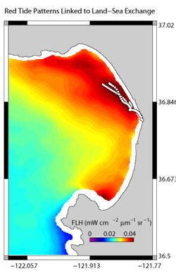
Satellite and surface currents data in Monterey Bay suggest that inputs from coastal watersheds may contribute to the occurrence of algal blooms (Figure 30). Studies of a major red tide event in Monterey Bay during 2007 indicated bloom inception occurred where rain induced flushing of watersheds entered the ocean (Ryan et al. 2008). Although nutrient inputs are likely to be small relative to seasonal upwelling, the influence of nitrogen sources such as urea on HAB dynamics in Monterey Bay is important since such inputs are likely linked to populous zones of the coast (Kudela et al. 2008a). The massive increases in eutrophication globally that have occurred during recent decades may play an important role in local increases in the frequency, spatial extent and duration of HABs (CIMT 2006, Howarth 2008). Heisler et al. (2008) conclude that there is a scientific consensus that nutrient pollution promotes the development and persistence of many HABs and that management of nutrient inputs can lead to a significant reduction in HABs.
HABs can negatively affect the ecosystem either due to their production of toxins or due to the manner in which the cells' physical structure or accumulated biomass affect co-occurring organisms and alter food web dynamics (Anderson et al. 2002). In California, HAB problems are dominated by two organisms, Alexandrium catenella, which produces a toxin that causes paralytic shellfish poisoning (PSP) and Pseudo-nitzchia, which produces the neurotoxin domoic acid (Anderson et al. 2008). Domoic acid and PSP toxins have been detected in the offshore food web in Monterey Bay and in some cases have been linked to mortality events of seabirds and marine mammals (Fritz et al. 1992, Scholin et al. 2000, Jester 2008). HABs (including those from algal species that do not produce toxins) can deplete oxygen levels as the blooms decay or they can destroy habitat for fish or shellfish by blocking light from reaching submerged vegetation. In 2007, a bloom of the dinoflagellete Akashiwo sanguinea was responsible for a mass-stranding event of seabirds in Monterey Bay. Jessup et al. (2009) determined that the algae did not produce a biotoxin, but instead produced a detergent-like protein that dissolved the natural oils found in the feathers of seabirds, which prevented the birds from flying, hunting, and keeping warm. In all, 550 birds were found stranded, while 207 were found dead.
3. Do Sanctuary waters pose risks to human health?
A rating of "good/fair" is given in response to the question with an "undetermined" trend since selected conditions have the potential to affect human impacts, but impacts have not been reported. Selected conditions in offshore waters, including low levels of a number of toxic pollutants and toxins produced by HABs have the potential to affect human health. While there is some evidence of increasing loads of biotoxins and contaminants, a clear trend in the risk to human health could not be determined.
POPs and biotoxins tend to biomagnify as they are passed up the food chain, and long-term exposure can be toxic to a wide range of animals, including humans. Some large, wide-ranging species of fish, marine mammals (e.g., killer whales), and pelagic seabirds (e.g., Black-Footed Albatross) found in offshore waters of the sanctuary have been tested for contaminants and show detectable levels of some contaminants such as DDT, PCBs, and chlordanes (Black et al. 2003, Kannan et al. 2004, Finkelstein et al. 2007). Such contamination, however, has not been directly linked to the water quality conditions in the offshore environment of the sanctuary. Similarly, elevated concentrations of some trace metals, such as mercury, are a health concern for humans who consume some species of large pelagic fishes, such as swordfish and albacore tuna. However, trace metal concentrations are not being monitored in either the offshore waters or in offshore species. Thus, it is not known if fishes harvested in the sanctuary have elevated levels of these contaminants or if the offshore environment of the sanctuary is a significant source of trace metals into the offshore ecosystem.
The toxins produced during harmful algal blooms can accumulate in the marine food web, especially in some fishes and shellfish, and therefore, pose a health risk when consumed. For example, in 1991 and 1998 large blooms of Pseudo-nitzschia australis, a diatom that can produce the neurotoxin domoic acid, were observed in Monterey Bay. Subsequently, domoic acid was detected in planktivorous fishes (e.g., anchovy, sardines) and linked to the deaths of fish-eating birds and mammals (Fritz et al. 1992, Scholin et al. 2000). Recent studies have shown that inputs of urea and copper may promote the growth of domoic acid-producing phytoplankton and may increase the production of domoic acid resulting in higher toxicity blooms (Armstrong et al. 2007). A shift in the taxonomic structure of the phytoplankton community occurred in 2004 towards dinoflagellate species that produce paralytic shellfish poisoning toxins rather than domoic acid (Jester 2008). PSP toxins were detected in samples of northern anchovies and Pacific sardines collected between 2003 and 2005, which was the first time these toxins have been detected in California's pelagic food web (Jester 2008).
4. What are the levels of human activities that may influence water quality and how are they changing?
The Beach Coastal Ocean Mammal and Bird Education and Research Surveys (Beach COMBERS) Program uses trained volunteers to survey beached marine birds and mammals monthly at selected sections of beaches throughout the Monterey Bay area.
The level of human activities that directly influence offshore water quality are considered to be "fair" in that they result in measurable local impacts to the ocean and "improving" due to increased regulation and remediation efforts since establishment of the sanctuary. In many instances it is difficult or impossible to directly measure the impacts of human activity on offshore water quality conditions, but select activities have notable impacts. The main contributor from land-based activities is inputs of contaminants and nutrients linked to urban development and agriculture. The main activity occurring in the offshore waters of the sanctuary is vessel traffic, which can result in acoustic impacts and discharge of ballast water, bilge oil, and trash.
In recent years, algal blooms in Monterey Bay have occurred more frequently and have been more persistent than in past years (CIMT 2006). Humans could be influencing algal blooms by increasing nutrient availability via runoff, climate change, or by assisting in the transport of new species into an area (Glibert et al. 1995, CIMT 2006). Human-derived runoff, sewage, and fertilizers may be interacting with increased sea surface temperatures to alter the natural pattern of blooms.
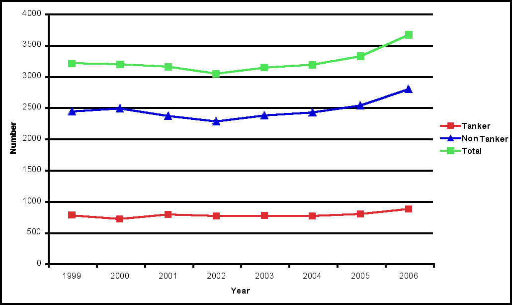
Vessel traffic in and out of San Francisco Bay and Monterey Bay ports has the potential to negatively impact water quality in the offshore environment of the sanctuary. Based on trends in the number of deep draft vessels entering San Francisco Bay, it is likely that vessel traffic through the offshore waters of the sanctuary has increased in recent years (Figure 31). Oil spills from on-going vessel activity, as well as oil releases from sunken vessels in and adjacent to the sanctuary, pose substantial risk to sanctuary resources. In response, the sanctuary developed strategies to movevessel traffic zones farther offshore and use north-south transit lanes to reduce threats of spills from vessels such as tankers, ships containing hazardous materials, barges, and large commercial vessels. These strategies have been approved at the international level and were implemented in 2000. Recent remediation efforts to remove oil from submerged vessels have reduced further the risk of oil spills. Oil leaking from the S.S. Jacob Luckenbach, which sank offshore of the Golden Gate in 1953, was responsible for significant seabird oiling events in the winter of 1997-98, 2001-2002, and 2004-05. Removal of approximately 100,000 gallons of bunker oil from this submerged vessel has removed this source of oil into the offshore waters of the sanctuary.
Sanctuary regulations prohibiting the dumping of grey water and bilge water, including recent additional limitations on discharges from cruise ships, serve to reduce some impacts of these activities on water quality. For example, the Beach COMBERS monitoring program found that the average oiling rate of beachcast bird carcasses (percent oiled carcasses per kilometer per month) was 2% during 1997-2002, which was less than the 8% oiling rate recorded by Pt. Reyes Bird Observatory during 1971 - 1985 (Nevins et al. 2003). This comparison indicates that oil pollution prevention measures implemented during the past 20 years have likely reduced oiling rates in the sanctuary. However, the continued observation of oiled bird carcasses on sanctuary beaches (Nevins et al. in prep) and the observation of oil slicks during aerial surveys of offshore living resources from 2001 to 2008 (K. Forney, NMFS-SWFSC, unpubl. monitoring data) suggest that continued mitigation and enforcement of sanctuary regulations is needed to further reduce the release of oil discharge into the offshore waters of the sanctuary.
Offshore Environment Water Quality Status and Trends
Status: Good Good/Fair Fair Fair/Poor Poor Undet.
Trends:
▲ Conditions appear to be improving. The offshore environment of the sanctuary can be divided into pelagic habitats (i.e., the water column) and benthic habitats (i.e., the seafloor). Pelagic habitats are more difficult to define than benthic habitats, and although these habitats play a key role in the sanctuary ecosystem, they are less well studied than the benthic habitats. This is due, in part, to the logistical and economic hurdles that must be overcome when using large vessels to deploy nets, remotely operated vehicles or submersibles to sample and explore this vast volume of water that is in a constant state of flux. Nevertheless, it is widely recognized that the productivity of the offshore ecosystem supports a great diversity and abundance of invertebrates, fishes, seabirds, and marine mammals. It should be noted, however, that due to the relative dearth of biological knowledge on the water column itself, the offshore environment status and trends are focused primarily on benthic habitats, since this is where the bulk of knowledge resides. The physical and chemical oceanography of the offshore pelagic habitat was discussed in the Water Quality section (above). The following information provides an assessment of the status and trends pertaining to the current state of offshore marine habitats. 5. What is the abundance and distribution of major habitat types and how is it changing? The abundance and distribution of major habitat types in the offshore environment of the sanctuary is rated as "fair" based on the past and current levels of human activities that influence the distribution, abundance, and quality of benthic habitats and associated living resources. The trend could not be determined due to a lack of information on both the rate and degree of recovery of habitat and associated living resources inside areas recently closed to bottom-contact fishing gear and the associated changes in the distribution and intensity of fishing activities in the remaining open areas. The most abundant habitats in the Monterey Bay sanctuary are the open waters - three-dimensional habitats not associated with the seafloor. The total volume of open waters of the sanctuary is 12.026 trillion cubic meters or approximately 4.8 billion Olympic-sized swimming pools. Open water can be subdivided into three zones by depth. The epipelagic zone, which includes the upper 200 meters of the water column, comprises 18% of the open water habitat. The mesopelagic zone, from 200 to 1,000 meters, makes up nearly half of the open water. The remaining 35% of the volume of the open water is deeper than 1,000 meters and is called the bathypelagic zone. The abundance and distribution of the major water column habitats in the sanctuary have not changed over the last few decades, but the quality of these open water habitats is influenced by natural and anthropogenic factors. These changes in the quality of open water habitats have been discussed in the water quality section of this report.
As of September 2007, approximately 72% of the benthic habitats in the offshore waters of the Monterey Bay sanctuary have been mapped with good resolution using sidescan sonar (16%) and multibeam (64%), including some areas of overlap (National Marine Sanctuary: Seafloor Mapping Data Inventory, Figure 32). The remaining 28% of the area has been mapped with a resolution of 200 meters using drop-line surveys (NOAA National Ocean Service). The majority of the benthic habitat in the offshore environment is composed of soft sediments with various mixtures of sand, mud, and silt. Under natural conditions, these soft-bottom habitats are structured by both physical processes, such as currents, and the activities of animals that increase the physical complexity of the habitat by creating mounds, burrows, and depressions. Hard substrates, such as deep reef, rock, and gravel, occur in patches of various sizes, but tend to be less abundant in the deeper portions of the sanctuary. Attached and emergent living organisms, such as deep-sea corals, sponges, and sea pens, provide additional structure. All these different types of fine-scale habitat structure can be used by fishes, crabs, and other taxa as refugia from predation and currents.
Most of the offshore environment in the Monterey Bay sanctuary has not received the detailed characterization and monitoring necessary to quantify the impact of human activities on the distribution, abundance, and quality of major and finescale benthic habitat types and associated living resources. It is unlikely that human activities, such as the installation of submerged cables and fishing with bottom-contact gear, have substantially altered the abundance and distribution of major habitat types. However, based on limited study within major habitat types, these human activities can alter the physical complexity of sediments and alter or remove less common meso-scale habitat types (e.g, bolder, rock, corals) and their associated living resources.
In 2002 NOAA's Office of Oceanic and Atmospheric Research (OAR), in collaboration with researchers from the Monterey Bay Aquarium Research Institute and the sanctuary, studied the impact of the Pioneer Seamount cable, a 95 kilometer long coaxial cable installed in 1995 (Kogan et al. 2006). At depths below 20 meters, there was little evidence of effects of the cable on the seafloor habitat. The cable did appear to influence the abundance and distribution of a few benthic species. Sea anemones colonized the cable when it was exposed on the seafloor, and were therefore generally more abundant on the cable than in surrounding, sediment-dominated seafloor habitats (Figure 33). Some fishes were also more abundant near the cable, apparently due to the higher habitat complexity it provides.
The most widespread physical alteration of sanctuary habitats has likely resulted from fishing with bottom-contact gear, such as otter trawls. Among the various environmental impacts resulting from use of this type of gear are removal of structure-forming organisms and the smoothing of bedforms (Auster and Langton 1999, Lindholm et al. 2004). The results of a recent habitat recovery project along the central coast of California (de Marignac et al. 2009) indicate that microtopographic structures on the seafloor, such as biogenic depressions and biogenic mounds, were significantly more abundant in an area that was recovering (3+ years) from trawling as compared to an area that continued to be actively trawled. Similar effects were observed in the Monterey Bay sanctuary in the late-1990's (Engel and Kvitek 1998). Although detailed information on historic and current conditions in the sanctuary's offshore seafloor habitat is limited, the degree and extent of alteration to the physical complexity of these habitats resulting from past activity are a cause for concern. Based on the known physical impacts of bottom trawling (NRC 2002), the limited study of trawling impacts to habitat in the sanctuary, the known extent of trawling effort in the sanctuary over the past 11 years (Figure 34), and the long history of bottom-contact gear use in the offshore environment, the condition of offshore habitats is considered to be "fair". While many impacts to soft-sediments may be less persistent (e.g., homogenization of sediment structure and loss of microhabitat structure), other impacts are long-term (e.g., removal or displacement of boulders and rocks).
A variety of recent management measures directed towards trawling, including an expansion of the prohibition on the use of bottom trawling gear in state waters, the Rockfish Conservation Area, and the Essential Fish Habitat Closures (Figure 35), have limited the extent of trawling activity in the sanctuary. Due to gear limitations, trawling is unlikely to occur in waters deeper than 700 fathoms. The prohibition on the use of bottom trawl gear at depths below 700 fathoms, which began in 2006, prevents an expansion of trawling into this untrawled area. The combined effect of these management measures by NOAA's National Marine Fisheries Service and the Pacific Fisheries Management Council is to prohibit the use of bottom trawling gear in 55.5% of the Monterey Bay sanctuary. The effect of these measures may be an improvement in the condition of offshore habitats due to some recovery of seafloor habitats in the areas that were previously trawled, though a directed study to determine the degree and the speed of recovery for different ecosystem components is needed.
6. What is the condition of biologically structured habitats and how is it changing?
The condition of offshore, biologically-structured habitats is rated as "fair/poor" and the trend is "undetermined." A variety of structure-forming and structure-building species occur in the offshore environment of the sanctuary. However, information on the distribution and condition of these organisms is limited, especially in more remote areas and in comparison to historic abundance and distribution patterns. ROV surveys have recorded a variety of structure-forming species, including soft-corals, gorgonians, sponges, and brachiopods, on the continental slope and submarine canyons in the central and northern portions of the sanctuary (J. Barry, MBARI, unpubl. data). NOAA Fisheries trawl surveys of the continental shelf and slope provide additional records of corals, sponges, anemones, sea pens, and sea whips in the sanctuary (NMFS 2004). These data are augmented by recent towed camera sled and submersible video surveys by the sanctuary in limited areas and occasional observations by West Coast research institutions (Etnoyer and Morgan 2003). The Monterey Submarine Canyon was identified as an area with a relatively high concentration of deep-sea corals compared to other areas along the west coast (Morgan et al. 2005).
Two additional types of biologically-structured habitats in the sanctuary, cold seep communities and whale falls, are known to support very diverse and unique biological communities. Cold seep communities, which are characterized by bacterial mats and chemosynthetic clams and tubeworms, have been found most frequently on steep slopes at depths exceeding 550 meters (Figure 36) (Barry 1996, Paull et al. 2005). It is likely that these long-lived communities occur throughout the sanctuary, but very little exploration of deep-sea habitats has occurred outside the Monterey Bay region. Researchers monitoring whale falls (the sunken carcasses of whales) in the sanctuary have found that these carcasses support a wide diversity of species, including mobile scavengers, dense assemblages of worms and crustaceans, and sulphur-loving bacteria, some of which are newly discovered species (Goffredi et al. 2004).
Activities that injure or remove structure-forming invertebrates and associated physical structures result in losses of habitat that supports the offshore living resource assemblage. The most significant impact to structure-forming invertebrates has likely resulted from fishing with bottom-contact gear, such as otter trawls. The results of a recent habitat recovery project along the central coast of California (de Marignac et al. 2009) show that significant differences exist in both microhabitat structure (biogenic mounds and depressions) and macrofaunal invertebrate community structure between an area that was recovering (3+ years) from trawling as compared to an area that continued to be actively trawled. During ROV surveys of the deep seafloor, researchers have observed that areas without trawl marks on the soft bottom tend to have more benthic invertebrate megafauna and associated species and show more advanced community development compared to areas with trawl marks (J. Barry, MBARI, pers. comm.). The impacts of bottom-contact gear on the benthos are very evident and it is possible that ecosystem integrity has suffered as a result of degradation of the benthic community. However, this is an area of research that is, in general, data poor. Based on the known negative impacts of bottom-contact fishing gear on biologically-structured habitats (Morgan and Chuendpagdee 2003) and the extensive use of these gears in the offshore environment in the past (Figure 34), it is likely that these habitats have been impacted in portions of the sanctuary where these gears were used. However, studies of these deep-sea communities are very limited and the impact of trawling and other human activities have not been assessed broadly. Approximately 25% of the sanctuary is deeper than 700 fathoms and thus inaccessible to existing bottom trawl gear (blue grey hatching in Figure 35 in Habitat section, Question 5). Given the recent closures of approximately 30% of the trawlable area to bottom trawling gear (see Figure 35 in Habitat section, Question 5), the status of structure-forming habitats may be improving in the closed areas. The trend is undetermined at this time. These habitats may not recover quickly or may never re-establish to their original abundance or composition even in the absence of future pressures. 7. What are the contaminant concentrations in sanctuary habitats and how are they changing?
Based on elevated levels of pesticides in shelf and canyon sediments at sites offshore of urban and agricultural pollution sources the condition of offshore habitats is rated as "good/fair". The trend in contaminant concentrations in offshore habitats has not been well studied. However, limited research suggests little to no attenuation in the concentration of some persistent contaminants in sediments on the continental shelf and continued inputs and delivery of some contaminants to deep sea habitats, such as submarine canyons. This limited information suggests an overall "declining" trend for this question.
Sediment samples have been collected annually since 2001 from eight sites along the 80-meter contour in Monterey Bay to test for persistent organic pollutants (CCLEAN 2006). Sediment quality guidelines predictive of toxicity called the NOAA Effects Range-Low (ERL) were exceeded for dieldrin in 30 of the 48 samples (Figure 37) (CCLEAN unpubl. monitoring data). Concentrations of DDTs in every sediment sample exceeded the ERL and also exceeded the average concentration of DDTs in San Francisco Bay sediments collected in 2002 (Figure 37) (CCLEAN 2009). Comparison of these DDT levels with those in sediments collected from nearby sites in 1969-1970s indicated that only one site in southern Monterey Bay has experienced a significant decline in DDTs (CCLEAN 2006). Samples from the shelf and slope (down to 1200 meters), and in submarine canyons between San Francisco and the Big Sur coast indicate that DDT concentrations are highest in sediments on the shelf between Half Moon and Monterey Bays and in Ascension, Año Nuevo, and Monterey/Soquel Canyons (Hartwell 2008). Watersheds in the Monterey Bay, especially the Salinas and Pajaro watersheds, appeared to be the primary source of DDT, which were then delivered to the deep ocean via all three canyons (CCLEAN 2006, Hartwell 2008). A similar pathway was identified by Paull et al. (2002) based on a trail of residues of the pesticide DDT. The residues marked the axis of Monterey Canyon as the pathway for sediment transport between the continental shelf and the deep sea. Dilution of the pesticides appeared to occur primarily at the coastline, with little further dilution as the sediments moved downslope into >3 kilometer water depths. A comparison of PAH and PCBs concentrations in sediment samples from the shelf, slope, and submarine canyons between Point Reyes and the Big Sur coast, found the highest levels in the canyons, and the lowest concentrations on the shelf (Hartwell 2008) (Figure 38). Normalizing data for total organic carbon (TOC) content of the sediment shows where concentrations are elevated after adjusting for the affinity of the sediment to accumulate organic contaminants. For the PAH and PCB data, this procedure illustrates that the sediments in the Gulf of the Farallones appear to receive PAHs and PCBs from San Francisco Bay through tidal exchange through the Golden Gate and the offshore sewer outfall more than from longshore drift up the coast. This study suggests that San Francisco Bay is the primary source of PAHs and PCBs to the Monterey Bay sanctuary.
There has been very limited study of the impacts of contaminants in offshore sediments on living resources. As part of the CCLEAN program, ecological effects on benthic infaunal species have been investigated by examining the relationship between sediment characteristics, river discharges, and the numbers of organisms for the most abundant taxa. Results suggest suspended sediment from the rivers, primarily the Pajaro River, may be having negative effects on benthic organisms along the 80-meter contour. Moreover, total abundance may be negatively affected by the cumulative concentrations of POPs (CCLEAN 2006). In a separate study, analysis of the concentration of persistent organic pollutants in demersal fish and invertebrates in the Monterey Bay region found an enrichment of both the PCBs and DDTs up to a factor of four when going from surface to deepwater fish, and a species of deep-sea brittle star showed the highest concentration of DDTs, chlordances and toxaphenes of all samples from the region (Froescheis et al. 2000, Looser et al. 2000). These studies suggest persistent contaminants are being transported to and sequestered in deep-sea habitats through sediment transport processes and that they are being incorporated into the local food web. 8. What are the levels of human activities that may influence habitat quality and how are they changing?
The level of human activities that influence habitat quality in the offshore environment is rated as "fair/poor" because bottom-contact fishing gear has been employed widely for many decades and marine debris has been accumulating for decades in offshore habitats. Recently, the level of fishing with bottom-contact fishing gear, particularly trawling, has been reduced by landing restrictions, gear restrictions, and area closures. Two federal gear restrictions adopted area-wide that reduce impacts to physical and biogenic habitat are: a restriction on the use of large footrope (roller) gear for continental shelf species implemented in 2000 (PFMC 2005); and a prohibition on the use of trawl nets to take spot prawn adopted by the Fish and Game Commission in 2003. The area closed to trawling in state waters was expanded in 2006 to include all of Monterey Bay and state waters south of Yankee Point to Point Sur (see Figure 35 in Habitat section, Question 5). In federal waters, area closures were implemented to help rebuild overfished populations (Rockfish Conservation Areas (RCA)) and protect groundfish essential fish habitat (EFH) (see Figure 35 in Habitat section, Question 5). The Trawl RCA restricts commercial bottom trawling for federally regulated groundfish near the outer edge of the continental shelf and the non-trawl RCA restricts longline, hook and line, and pot gear for groundfish on the continental shelf from 30 to 150 fathoms. The EFH areas in the Monterey Bay sanctuary restrict the use of bottom trawl gear. These changes in fisheries management have resulted in decreases in the overall trawling and bottom fishing effort, but may also lead to redistribution of fishing effort and increased fishing pressure in areas open to fishing. Two other activities that can negatively influence the quality of offshore benthic habitats are installation of submerged cables and loss of fishing gear. Installing submerged cables is strictly regulated by the sanctuary. Four new cables, with a combined total length of 114 kilometers within sanctuary boundaries, have been permitted since the sanctuary was designated in 1992. A recent survey of the ATOC/Pioneer Seamount cable found no measurable impacts of the cable on benthic habitat below 30 meters and only minor influences of the cable on the abundance and distribution of benthic invertebrates (Kogan et al. 2006).
Marine debris directly alters physical habitats by settling on the seafloor (i.e., adding artificial structure) or by removing/damaging biologically structured habitat. In addition, marine debris in the water column, such as lost fishing nets, poses an entanglement risk to pelagic animals, especially large fishes, sea turtles, seabirds, and mammals. Watters et al. (2008) examined the distribution, abundance, type, and potential impacts of marine debris on shelf and canyon benthic habitats in the Monterey Bay region in 1993 and 1994 In this preliminary study 148 transects (typically 10-15 minutes in duration) with a combined length of 44,730 meters were surveyed. Marine debris was found along 47% of transects and was composed most frequently of plastic. Monofilament line used by recreational anglers was the primary source of the debris, followed by commercial fishing nets and longlines (Figure 39). The Monterey Bay sanctuary is working with partners to design and implement a multi-year project to remove lost fishing gear from the sanctuary. The dual purpose of the project is to help eliminate benthic and pelagic hazards to marine organisms posed by fishing debris lost on the bottom, and to provide outreach tools that would assist in the location of lost gear via reports from divers, researchers, fishermen and other parties.
Offshore Environment Habitat Status and Trends Status: Good Good/Fair Fair Fair/Poor Poor Undet. Trends:
▲ Conditions appear to be improving. Biodiversity is variation of life at all levels of biological organization, and commonly encompasses diversity within a species (genetic diversity) and among species (species diversity), and comparative diversity among ecosystems (ecosystem diversity). Biodiversity can be measured in many ways. The simplest measure is to count the number of species found in a certain area at a specified time. This is termed species richness. Other indices of biodiversity couple species richness with a relative abundance to provide a measure of evenness and heterogeneity. When discussing "biodiversity" we primarily refer to diversity indices that include relative abundance. To our knowledge no species have become extinct within the sanctuary, so native species richness remains unchanged since sanctuary designation in 1992. Researchers have described previously unknown species (i.e., new to science) in deeper waters, but these species existed within the sanctuary prior to their discovery. The number of non-indigenous species has increased within the sanctuary. We do not include non-indigenous species in our estimates of native biodiversity. Key species, such as keystone species, indicators species, sensitive species and those targeted for special protection, are discussed in the responses to questions 12 and 13. Status of key species will be addressed in question 12 and refers primarily to population numbers. Condition or health of key species will be addressed in question 13. Key species in the sanctuary are numerous and all cannot be covered here. Emphasis is placed on examples from various primary habitats of the sanctuary for which some data on status or condition are available. The following information provides an assessment of the status and trends pertaining to the current state of the sanctuary's living resources in the offshore environment. 9. What is the status of biodiversity and how is it changing?
Thorough historic and current inventories are not available to fully measure biodiversity status and trends in the sanctuary. Species richness remains unchanged; no species in offshore habitats are known to have become locally extinct. However, the relative abundance of those species has been altered substantially by both natural and anthropogenic pressures. Numerous species in the sanctuary have experienced population declines in recent decades to unprecedented low levels. Conversely, a few species that were uncommon visitors in past decades have increased in abundance in recent years, such as jumbo squid. Shifts in the relative abundance of multiple species, especially those at higher trophic levels, are indicators of compromised native biodiversity in the system and impact community and ecosystem structure and function. For these reasons, the status of native biodiversity in the offshore habitats of the sanctuary is rated "fair." However, the cumulative trend in biodiversity could not be determined due to a lack of information on the changes in relative abundance of many deep-sea species and an uncertainty in how to combine the individual trends in species abundance into a cumulative trend in biodiversity. A historical perspective suggests that many of the higher trophic level species in the offshore environment, such as marine mammals, seabirds, and predatory fishes, have been dramatically reduced by hunting and fishing. The protection and active management of marine mammal populations by state, federal, and international entities has allowed a full recovery of a number of mammal stocks that occur in the sanctuary, such as gray whales, harbors seals, northern elephant seals, and California sea lions (Angliss and Allen 2009, Carretta et al. 2008). On-going monitoring by the National Marine Fisheries Service is finding that other mammals stocks in the sanctuary remain at reduced levels (e.g., blue whales, harbor porpoise), though some are slowly increasing in abundance (e.g., humpback whales) (Angliss and Allen 2009, Carretta et al. 2008). Some locally breeding seabirds (e.g., Cassin's Auklets, Rhinoceros Auklets, Pigeon Guillemot, Pelagic Cormorant) have experienced reduced reproductive success in recent years due to poor feeding conditions in the coastal ocean (Goericke et al. 2007). Abundance of non-resident species, such as Sooty Shearwaters and Black-footed Albatrosses, have also declined within the waters of Northern California (Ainley and Hyrenbach unpubl. data), potentially due to population declines resulting from human impacts in remote locations. In addition, the central California population of Marbled Murrelets, a seabird that forages in sanctuary waters and nests in old growth forests adjacent to the sanctuary, was recently estimated between 122 and 225 individuals, which represents a 54-55% decline since 2007 and 71-80% decline since 2003 (Peery et al. 2008). This decline is attributed in large part to terrestrial human activities that result in the degradation or loss of breeding habitat. Decades of fishery extraction have contributed to a shift in the biodiversity of the fish assemblage in offshore waters. Based on fishery-independent trawl surveys conducted from 1977-2001 along the U.S. West Coast (including sampling sites throughout the Monterey Bay sanctuary), Levin et al. (2006) found that there have been fundamental changes in the fish assemblage on the continental shelf and slope. Populations of flatfishes, cartilaginous fishes, and small rockfishes have increased, while populations of large rockfishes have decreased. In 1977, rockfishes were more than 60% and flatfishes were 34% of the fish captured in the survey. In 2001, rockfishes were 17% and flatfishes were nearly 80% of the fish captured in the survey. The species that now dominate the shelf/slope assemblage have vastly different trophic roles and life-history strategies than the species they replaced. The abundance of jumbo squid (Dosidicus gigas) has increased recently in the sanctuary (Figure 40) and may be having impacts on both regional and local biodiversity. Observations from remotely operated vehicle surveys in the Monterey Bay region show that these large squid have been present and sporadically abundant since the 1997-98 El Niño event, particularly between 2003 and 2006 (Zeidberg and Robison 2007). This voracious predator consumes a variety of pelagic and semipelagic fishes, including commercially harvested species (e.g., Pacific hake, sablefish, various rockfishes), and could drive changes in the pelagic food web (Field et al. 2007). For example, the presence of jumbo squid in Monterey Bay surveys has been associated with declines in observations of Pacific hake (Zeidberg and Robison 2007). Jumbo squid are also a key forage item for many higher trophic level fishes and marine mammals throughout their range, including toothed whales and commercially important tunas, billfishes and sharks (Field 2008). These animals are likely to play a major role in structuring offshore ecosystems. The cause of the observed range expansion of jumbo squid has not been determined; possible contributing factors include a switch in the Pacific Decadal Oscillation, harvesting of large pelagic predators, and global warming. Biodiversity in deep-sea communities of the sanctuary is not well understood because of the logistical challenges of conducting research in deep water. Due to technological advances in undersea research, census and evaluation of ecological integrity of deep-sea habitats has only recently begun for midwater assemblages (e.g., MBARI Midwater Ecology ROV surveys) and benthic communities (e.g.,MBARI Benthic Ecology ROV surveys). For example, surveys of whale falls and cold seep communities have led to the discovery of several new species (Barry et al. 1996, Goffredi et al. 2004). There are indications that deepwater sponge and coral communities in the sanctuary have been impacted before many aspects of their basic biology and ecology could be ascertained. Overall, there is much that is unknown about the species richness and evenness of several important communities within the offshore habitats of the sanctuary.
10. What is the status of environmentally sustainable fishing and how is it changing?
Environmentally sustainable fishing or ecologically sustainable fishing may be defined as fishing at a level that the ecosystem can sustain without shifting to an alternative or undesirable state. To determine if environmental fishing is occurring, one has to simultaneously consider the impacts of all harvested species on an ecosystem, and community stability and resilience (Zabel et al. 2003). It is designed to consider fishery yield and the integrity of ecosystem structure, productivity, and function and biodiversity, including habitat and associated biological communities. The past decade has seen a paradigm shift in the management of fisheries from managing target stocks for maximum sustainable yield to ecosystem-based fisheries management. This shift leads to a more holistic consideration of sustaining fishery yield, as well as maintenance of marine ecosystems and their function. The status and trend ratings of "fair" and "improving" for this question are based on the available scientific knowledge (e.g., published studies, unpublished data, and expert opinion) of targeted and non-targeted living resources that are directly and indirectly affected by fishing. Because this is the first Monterey Bay sanctuary condition report, the status rating reflects a more historical view of the potential effects of fishing activity on biological community development, function, and ecosystem integrity, over the last two to three decades. Subsequent reports will take a more contemporary view of the ecosystem-level impacts of fishing. The status rating does not serve as an assessment of the status of current fisheries management practices in the region. However, the determination of an increasing trend for this question does reflect recent changes in fisheries management practices and their positive effects on living resources in the sanctuary. Historical accounts, ranging over several timescales from decades to centuries, demonstrate how commercial and recreational fisheries have extracted significant biomass from waters now encompassed by the Monterey Bay sanctuary, in part using methods that are known to reduce physical complexity and damage living structures of seafloor habitats. Several species of whales, pinnipeds, and large sharks were drastically reduced, at least in part as a result of historic fishing, and are currently at depressed population levels (Leet et al. 2001). The effects of reducing the abundance of currently fished stocks, in some cases to less than 50 percent of the unfished biomass, on ecosystem health and integrity are poorly researched and understood, but have the potential to alter ecosystems. Meanwhile, scientists are just beginning to understand fundamental elements of ecosystem function - the distribution and community composition of seafloor habitats, the distribution of and habitat requirements for different life stages of important commercial species, the significance of diverse age structures in sustaining fishery resources, and many other factors that influence community development and function. For these reasons, this question is rated "fair." The major commercial fisheries that operate in the Monterey Bay sanctuary target groundfish (rockfishes, flatfishes), pelagic finfish (salmon, sardines, anchovy, mackerel), and invertebrates (market squid, Dungeness crab, spot prawn). In the recreational fishery, commercial passenger fishing vessel anglers traditionally target rockfish, salmon, lingcod, and, opportunistically, albacore tuna (CDFG 2008b). Dungeness crab and jumbo squid are the main invertebrates targeted by the central and northern California recreational fishery (CDFG 2008b). In general, fisheries managers appear optimistic that sustainable fisheries in the offshore waters of the sanctuary are possible under new management regimes following historical stock declines. Marine communities in the Monterey Bay sanctuary are subject to complex pressures and interactions and many targeted species are long lived, therefore fishery management actions aiming to allow population recovery may experience a long lag period before changes are observed. Of the 80 species of groundfish managed under the PFMC's Groundfish Fishery Management Plan, 22 species are managed at the species level. The remaining species are either unassessed or managed in groupings or stock complexes, because individually they comprise a small part of the landed catch or stock assessments have not been completed. For some species, it is unlikely that sufficient information exists to develop adequate stock assessments. The status and management of many groundfish stocks has undergone dramatic changes over the past few decades. Beginning in the 1970s, improved understanding of life history characteristics led fisheries scientists to conclude that many groundfish species were incapable of sustaining high-intensity fishing pressure using modern fishing methods. Over the next two decades, several groundfish stocks became depleted due to a combination of fishing and natural factors. Since the late 1990s, some formerly depleted groundfish species have recovered quickly (e.g., English sole), while others are rebuilding more slowly (e.g., bocaccio). Four rockfish species - bocaccio, cowcod, yelloweye rockfish, and darkblotched rockfish - are currently considered overfished). All depleted rockfish species with stock assessment data are showing increasing trends in spawning biomass over the past 10 years (Figure 41). Moreover, 11 out of 18 rockfish species show evidence of increasing average body size since 1999 (S. Ralston, NOAA/NMFS, unpubl. data). The recent increase in size of these fishes is consistent with a response to reduced fishing effort. Salmon have been one the most important species in both commercial and recreational fisheries in the Monterey Bay sanctuary. Managing ocean salmon fisheries is an extremely complex task, due in large part to the wide oceanic distribution of the salmon and difficulty in estimating the size of salmon populations. Salmon at all life history stages are affected by a wide variety of natural and anthropogenic factors in the ocean and on land, including ocean and climatic conditions, habitat degradation and loss, and predation (including humans). Other challenges to a sustainable salmon fishery off central California coast include judging the effects of different regional fisheries on salmon stocks, competition between wild and hatchery salmon, and restoring freshwater habitat. In the last 20 years, commercial and recreational catches of salmon in California have fluctuated in response to population trends, regulatory seasons, and quotas. Many of the salmon stocks that occur off California are listed as threatened or endangered under the Endangered Species Act. Ocean salmon fisheries in California primarily target Chinook salmon since the retention of coho salmon was prohibited in the commercial and recreational fisheries in 1993 and 1996, respectively. Recently, the low returns of Chinook salmon in two stocks, the Klamath River fall run and the Sacramento River fall run, led to very restrictive limits on commercial and recreational fishing for salmon in 2006 and a complete closure of both fisheries south of Cape Falcon, Oregon in 2008 (PFMC 2006, 2008). Pacific sardine, market squid, northern anchovy and Pacific mackerel are four of the largest volume fisheries in the state of California (CDFG 2008b). Sardine, anchovy, and mackerel stocks are assessed by the National Marine Fisheries Service, whereas market squid and anchovy stocks are monitored by the California Department of Fish and Game. Landing data dating back a couple decades show large fluctuations in harvest for each of these species (Leet et al. 2001, CDFG 2008b). Some of these fluctuations in landings may be due to changes in management, but it appears that population size for these species tends to be influenced strongly by prevailing oceanographic conditions (Leet et al. 2001). Currently, these coastal pelagic fisheries in California appear to be healthy (CDFG 2008b). The commercial Dungeness crab fishery is one of the top value fisheries in the state (CDFG 2008b). Historically, this fishery has been cyclical with abundance peaking approximately every 10 years (CDFG 2008b). The large fluctuation in landings is likely due to varying ocean conditions including water temperature, food availability and ocean currents (Leet et al. 2001). The Dungeness crab and spot prawn fishery are trap-based fisheries with low by-catch and both appear to be environmentally sustainable fisheries (Leet et al. 2001, Hankin et al. 2004, Larson and Reilly 2008). Despite the improving trend for many harvested groundfish species and the more restrictive fisheries management measures that have been implemented for groundfish, finfish, and invertebrate fisheries, there is still concern over the ecological impact of the past and present fishing activities in the sanctuary. Fishing can alter marine ecosystems both by altering local environments, as when trawls drag across the ocean floor, and by modifying community composition (Zabel et al. 2003). MBARI ROV surveys of the continental shelf and slope in the sanctuary commonly observe trawl marks on soft bottom. Soft-bottom areas that were trawled have been denuded of benthic invertebrate microfauna and associated species, whereas areas that lack trawling show much more advanced community development (Jim Barry, MBARI, pers. comm.). The impacts of the trawl fishery to benthic habitats and communities are very evident and it is possible that ecosystem integrity has suffered as a result of degradation of the benthic community (Jim Barry, MBARI, pers. comm.). Even nominal amounts of trawling in a pristine area can lead to significant damage. Closures of some areas to trawling should lead to improvements over time, but other areas may receive higher pressure due to fishery displacement. Very little is known about the community and ecosystem-level consequences of repeatedly removing a large portion (up to 60%) of the biomass of multiple species in the same ecosystem. However, some recent studies lead to concerns that past fishing activity has impacted community function and ecosystem integrity in the sanctuary. Levin et al. (2006) found that over the last 25 years there have been fundamental changes in the fish assemblage on the continental shelf and slope of the U.S. Pacific coast. Populations of flatfishes, cartilaginous fishes, and small rockfishes have increased, while populations of large rockfishes have decreased. The species that now dominate the shelf/slope assemblage have vastly different trophic roles and life-history strategies than the species they replaced. In a separate study, Yoklavich et al. (2000) compared the fish assemblage in an area of Monterey Bay that was a natural refuge from fishing to the assemblage in fished area. They found that sites that were less fished had larger fishes, and had significantly higher abundances of major commercial and recreational species, including boccacio and cowcod, than more heavily fished areas. Shifts in community composition may disrupt direct and indirect ecological processes inherent in food webs and alter community trophic interactions and energy flow. For example, in communities with complex species interactions, targeted removals of large predators from a population can reduce the resiliency of that community to perturbations (Baskett et al. 2006). Fishing can directly affect communities, as when it changes key life-history traits (Zabel et al 2003). For example, fisheries typically seek larger, more valuable fish, decreasing the average size of fish in the target populations. Past fishing practices have resulted in a decrease in both the mean size (Figure 41; Mason 1998) and local density (Yoklavich et al. 2000) of some targeted species, such as large-bodied rockfish, in the sanctuary. Though population-level changes have been measured in the sanctuary, the potential community-level consequences are poorly studied. One recent study by Harvey et al. (2006) estimated the impact of size and density changes on energy consumption and fecundity in a rockfish assemblage that included bocaccio - a large-bodied, overfished species. They found shifts in the allocation of energy and reproductive potential within the assemblage that had the potential to affect the ability of bocaccio and other large rockfish species to recover from overfishing. As mentioned above, a number of the fished stocks in the sanctuary are known to experience substantial fluctuations in abundance. Some of the fluctuation can be attributed to significant climate shifts that last from a couple of years to several decades. However, there is concern that fishing pressure may contribute to more frequent or more extreme fluctuations in abundance. A recent analysis of long-term monitoring data of the ichthyofaunal assemblage off of southern California found that fishing significantly increases temporal variability of populations in the ecosystem (Hsieh et al. 2008). Exploited populations were found to be more vulnerable to climate variability and lead to unstable boom and bust cycles. The likely cause of this increased variability is that selective harvesting can alter the basic dynamics of exploited population, such as intrinsic growth rates (Anderson et al. 2008). Drastic changes in the abundance of fished stocks could have substantial impacts on the offshore ecosystem, which consists of a complex web of pelagic and demersal fishes and invertebrates, marine mammals, and seabirds.
11. What is the status of non-indigenous species and how is it changing?
Non-indigenous species in offshore habitats are not suspected or do not appear to affect ecosystem integrity because very few non-indigenous species have been identified in these habitats. Therefore, the rating related to this question is "good" and the trend is "stable". Maloney et al. (2006) reported that four of the species identified from infaunal samples collected in deeper waters (30-120 m) offshore of California were introduced: Anobothrus gracilis, Laonice cirrata, Melinna oculata andTrochochaeta multisetosa. All of these species are polychaete worms (phylum: Annelida), and represented only 1% of the total annelid taxa identified from infaunal samples. Some species that forage in the open ocean are adversely affected by introduced species in habitats outside the boundaries of the Monterey Bay sanctuary, such as in other portions of their geographic range. For example, predation by introduced black rats on eggs and chicks has negatively impacted the reproductive success of nesting seabirds on Anacapa Island, near the Channel Islands sanctuary. Removal of this introduced species has resulted in substantial recovery of rare seabird populations on the island, including Brown Pelican and Xantus's Murrelets that forage during the non-breeding season in the Monterey Bay sanctuary. 12. What is the status of key species and how is it changing?
The status of key species in the offshore environment is rated "good/fair" and the trend is "stable." There are many high-profile species in offshore habitats. These include cetaceans, seabirds, pelagic fishes (e.g., salmon, tunas, sharks), and sea turtles. Many of these are apex predators and play important ecological roles in the sanctuary ecosystem. Here we focus on a few examples from each of the major species groups. Among seabirds, Sooty Shearwaters are key species because of the extremely high densities reached during the summer, when hundreds of thousands of adults forage for fishes and squid in sanctuary waters after migrating from the southern hemisphere (Adams and Harvey 2006). A 32% decline in average densities of Sooty Shearwaters was calculated from the period 1985-1994 to the period 1997-2006 based on shipboard surveys in central California (Ainley and Hyrenbach, unpubl. data). This decline is due potentially to a number of factors occurring outside the Monterey Bay sanctuary including changes in oceanographic conditions and human impacts in remote locations (Hyrenbach and Veit 2003, Scofield and Christie 2002). Stock assessments suggest that many of the populations of marine mammals that use sanctuary habitats are stable or increasing (Carretta et al. 2008, Angliss and Allen 2009). For example, there is evidence suggesting an increasing population for the eastern North Pacific humpback whale stock (Calambokidis et al. 2004). The population of Steller sea lions off California and Oregon is stable or increasing very slowly (Angliss and Allen 2009). The abundance of this threatened species in the sanctuary is monitored by observing the number of pups and non-pups at the breeding colony on Año Nuevo Island. Pup counts and non-pup counts taken in July have decreased from 1990-2004 at an average annual rate of -2.63% and -1.28%, respectively (M. Lowry, NMFS-SWFSC, pers. comm.). Similar declines have been observed at South Farallon Island, a breeding colony just north of the Monterey Bay National Marine Sanctuary. Salmon are key species in the sanctuary due to their important role in both the offshore foodweb and in commercial and recreational fisheries. Historically, salmon were abundant in central California rivers, estuaries, and offshore waters. Currently, the abundance of salmon in the sanctuary is drastically reduced and many of the salmon stocks in central California have been listed under the federalEndangered Species Act. Salmon at all life history stages are affected by a wide variety of natural and human-caused factors in the ocean and on land, including ocean and climatic conditions, habitat degradation and loss, and predators (including humans). Ocean survival of salmon can be an important influence on overall population size, and differential ocean survival depends on oceanic conditions. Both the Pacific Decadal Oscillation (PDO) and climate change influence salmon abundance in the sanctuary.
Forage species (e.g., krill, anchovies, squid) are among the most important to the ecosystem as a whole. These forage species directly and indirectly support the tremendous abundances and species diversity of higher trophic levels. Squid serve as both predator and prey in offshore food webs. Market squid are seasonally abundant and population size appears to be influenced more by prevailing oceanographic conditions rather than by fishing pressure, though additional research is needed to better understand the relative influence of environmental variability and fishing pressures on the biomass of this stock (Porzio and Brady 2008). Krill is an abundant shrimp-like crustacean that directly or indirectly feeds much of the pelagic food web. To date there has never been an active fishery for krill along the U.S. West Coast. To assure the protection of this resource for the marine mammals, seabirds, and fishes that rely on krill as a primary food source regulations prohibiting the harvest of krill in state waters of California, Oregon, and Washington were passed in 2000 by each state's legislature. Similarly, a prohibition on the harvesting of krill in the Exclusive Economic Zone (EEZ) off the coasts of California, Oregon, and Washington was adopted in 2006 by the Pacific Fisheries Management Council. The National Marine Fisheries Service published a final rule in the Federal Register which went into effect on August 12, 2009.
Phytoplankton is another key component of the ecosystem, and consists of multiple species. Starting in 2003, the biomass of dinoflagellates increased dramatically in the surface waters of the sanctuary, and was correlated with a decrease in upwelling, favorable winds and increases in both water column stratification and surface chlorophyll (an indicator of overall phytoplankton biomass) (Figure 42) (Pennington et al. 2007). This recent change in the phytoplankton assemblage, from a diatom-dominated to a dinoflagellate-dominated assemblage, persisted into 2006 and almost certainly has ecological consequences, most of which are unknown. 13. What is the condition or health of key species and how is it changing?
The condition of key species in the offshore environment is rated "good/fair" and has a "declining" trend. The health of several key species has been compromised by exposure to neurotoxins produced by harmful algal blooms, entanglement in active and lost fishing gear, ingestion of marine debris, and accumulation of persistent contaminants. The continued input of non-biodegradable marine debris and persistent contaminants into the offshore waters of the sanctuary combined with the lack of attenuation of legacy contaminants, indicates that these threats to the condition of key species have steadily increased over the past decades and will continue to increase in the future. Some species of phytoplankton produce natural toxins that adversely affect several apex predators, including marine mammals and seabirds that forage offshore. In particular, domoic acid, a neurotoxin produced by the diatom Pseudo-nitzschia, has been problematic. For example, along the central California coast over 400 California sea lions died and many others displayed signs of neurological dysfunction during May and June 1998, during the same time period that a bloom of Pseudo-nitzschia was observed in the Monterey Bay region (Scholin et al. 2000). Large blooms of domoic acid producing phytoplankton were observed in Monterey Bay during 2000, 2002, and 2007 and these blooms were suspected as the cause of increased numbers of stranded and dead seabirds and mammals recorded on beaches in the Monterey Bay region by the BeachCOMBERS (Coastal Ocean Mammal / Bird Education and Research Surveys) monitoring program (Nevins et al. in prep). A health concern for key species in the sanctuary, including marine mammals, seabirds, and sea turtles, is interaction with active and lost fishing gear. Monitoring of hauled-out seals and sea lions on Southeast Farallon Island (just outside the Monterey Bay sanctuary) during the period 1976-1998 documented a total of 914 individuals that were entangled in synthetic material (Hanni and Pyle 2000). Of a total of 6,196 live stranded seals and sea lions admitted to a rehabilitation center on the central California coast from January 1986 to September 1998, 107 (1.7%) had lesions caused by entanglement with manmade marine debris, including active or discarded fishing nets and monofilament line, packing straps, plastic bags, rope, and rubber o-rings (Goldstein et al. 1999). Ingestion of plastic marine debris is a health concern for a number of seabird species in the sanctuary. The sanctuary's BeachCOMBERS monitoring program has collected carcasses of dead seabirds for study by local researchers. Analysis of the stomach contents of 190 Northern Fulmars collected along Monterey Bay beaches in 2003-2004 found that 71% of the birds had plastic in their stomachs (Nevins et al. 2005). In similar studies, plastic was observed in the stomachs of 67% of the 27 Red Phalaropes collected in 2005-2006 (Zabka et al. 2006) and 56% of the 16 Horned Puffins collected in 2007 (Phillips et al. 2007). These species of seabirds, and other seabirds such as albatrosses and shearwaters, are migratory birds that depend on the highly productive waters of Monterey Bay to feed. These seabirds are susceptible to plastic ingestion everywhere they feed, including the sanctuary. The high trophic level and longevity of marine mammals and seabirds put them at risk of accumulating contaminants in their bodies to levels high enough to cause potential health impacts. Measurable loads of organochlorides (e.g., PCBs, DDTs) have been observed in marine mammal and seabird species that occur in the sanctuary, including Steller sea lions (Jarman et al. 1996), harbor porpoise (Calambokidis and Barlow 1991), killer whales (Black et al. 2003, Krahn et al. 2007), Black-footed Albatross (Finkelstein et al. 2006, 2007), and the eggs of a number of species of locally nesting seabirds (Pyle 1999). However, a general lack of consistent long-term data coupled with the wide ranging movement patterns of these species make it difficult to determine whether habitats and prey resources in the sanctuary are a significant source of contaminants for these species. A recent meta-analysis of the available contaminant data in the sanctuary revealed the highest concentrations of multiple contaminants occurred in the Elkhorn Slough and Salinas Valley areas and are probably associated with legacy agricultural applications (Hardin et al. 2007). There has been no measurable attenuation for several legacy contaminants even though their application was banned 20-30 years ago, and PAHs and PCBs increased marginally at some sites (Hardin et al. 2007). Pinpointing the sources of these contaminants is difficult, since there are multiple processes and activities that could account for high contaminant concentrations in the sanctuary, including agricultural practices, urbanization, and some recreational activities. The decline of the central California breeding population of Steller sea lions may be caused by a combination of factors, including disease, elevated levels of organochlorine and trace metal contaminants (Jarman et al. 1996), competition for prey resources, and entanglement in fishing gear and other marine debris. In some cases, exposure to one threat may make the animals more susceptible to the others (e.g., high level of contaminants may make an animal more susceptible to disease). The relative importance of many of these threats is not known.
Chronic oiling has negatively affected seabirds in Monterey Bay National Marine Sanctuary, despite efforts to mitigate sources such as illegal dumping of bilge water and leakage of oil from sunken vessels. On average, when more than 2% of seabirds surveyed on sanctuary beaches are oiled, a significant oiling event has occurred; such was the case in the winters of 1997-98, 2001-2002, and 2004-05 (Figure 43). These events were subsequently attributed to oil leaking from the S.S. Jacob Luckenbach, which sank offshore of the Golden Gate in 1953. Removal of approximately 100,000 gallons of bunker oil from this submerged vessel has eliminated this source of oil into the offshore waters of the sanctuary.
14. What are the levels of human activities that may influence living resource quality and how are they changing?
A number of human activities, including fishing, inputs of marine debris, and the laying of submerged cables, influence the quality of living resources in the offshore portion of the sanctuary. The level of these human activities is rated "fair" because most of these activities have resulted in measurable impacts to living resource quality. However, recent changes in fisheries management that have resulted in improved status of fished species and reduced impacts to habitat and non-target species are the basis for an "improving" trend. Fishing is a human activity that influences sanctuary habitats and living resources in a number of ways beyond the removal of targeted biomass. The offshore seafloor has been negatively impacted by bottom-contact gear that disturbs bottom sediments, damages fragile biogenic animals (e.g., long-lived sponges and corals), and removes non-target species as bycatch. The recent closure of large portions of the offshore seafloor to bottom trawling (see Figure 35 in Habitat section, Question 5) should allow recovery of impacted habitats and associated living resources, though different species and habitats are likely to recover at very different rates and, in some cases, a full recovery may not be possible. Gear restrictions, such as changes in mesh sizes and deployment depths, have resulted in decreases in bycatch of protected and sensitive offshore species. For example, in 2002 the California Department of Fish and Game implemented a prohibition on the use of gillnets in waters shallower than 60 fathoms (approximately 110 meters) in central California to reduced the risk of entanglement of seabirds and marine mammals, including sea otters, harbor porpoise, and Common Murres (Forney et al. 2001).
Several fishery management actions over the last few decades led to a decline in the number of commercial fishing vessels registered statewide from approximately 9,200 in 1980 to 3,300 in 2004 (MLPA 2005). Similar declines in the number of commercial fishermen and vessels have been observed at the ports in the Monterey Bay sanctuary (for example see Figure 44). Decreases in the number of participants in commercial fisheries are due to a combination of many factors, including: the poor status of many rockfish stocks; increasingly restrictive fishery management regulations; attempts to reduce bycatch of species of concern; and the goal of reducing potential habitat damage from certain types of fishing gear. However, reductions in the number of participants and overall fishing effort in some sectors of the commercial fishery has not necessarily led to reductions in landings and values at all sanctuary ports. For example, although total landings at Half Moon Bay/Princeton area ports have declined over the period 1992 through 2006, total values have varied over these years, and show no consistent trend. Increased catches of higher value salmon and Dungeness crab in 2004 to 2006 helped maintain value as total landings declined (Figure 45). Commercial landings and values of finfish and invertebrates in Monterey over the period 1999 to 2004 are variable, but show no consistent trend (MLPA 2005).
Marine debris impacts marine life in many ways, most notably through entanglement and the ingestion of large plastics (greater than 10 centimeters in dimension) that can clog the digestive tract. Microplastics (less than 10 centimeters in dimension) are present and persist in the marine environment and originate from a variety of sources (Andrady et al. 1998). However, impacts of microplastics to organisms and the environment are largely unknown. Data that conclusively demonstrate negative impacts of microplastics on the marine environment are not available. The ability for plastics to transport contaminants has been documented, but the specifics of sorption and leaching are not fully understood (Arthur et al. 2009). A large amount of marine debris comes from land, swept by wind or washed by rain off highways and city streets, down streams and rivers, and out to sea. The California Department of Transportation conducted a litter management pilot study during 1998-2000 that found foamed polystyrene represented 15% of the total volume of litter recovered from storm drains (CIWMB 2004). Other significant items included moldable plastic (16%), plastic film (12%), and paper (14%). The Ocean Conservancy coordinates annual International Coastal Cleanup days. In 2007 the top 10 items collected worldwide included, in order of amount: cigarettes/cigarette filters, food wrappers/containers, caps/lids, bags, plastic beverage bottles, cups/plates/forks/knives/spoons, glass beverage bottles, cigar tips, and beverage cans. Foamed polystyrene is a significant component in coastal litter collection programs and monitoring studies. The 1999 U.S. Coastal Cleanup Dayfound that foamed polystyrene pieces were the fourth-largest amount of all materials collected, behind cigarette butts, plastic pieces, and plastic food bags and wrappers. Cable laying is another human activity that disturbs benthic communities because it requires digging a trench to bury the cable. The laying of submerged cables is strictly regulated by the sanctuary. Four new cables, with a combined total length of 114 kilometers within sanctuary boundaries, have been permitted since the sanctuary was designated in 1992. In a recent survey of the Acoustic Thermometry of Ocean Climate/Pioneer Seamount cable, few changes in the abundance or distribution of benthic fauna were detectable from video observations (epifaunal) and sediment core samples (infauna) indicating that the biological impacts of the cable are minor at most (Kogan et al. 2006). Sea anemones had colonized the cable when it was exposed on the seafloor. Some fishes were also more abundant near the cable, apparently due to the higher habitat complexity provided by the cable. In comparison to the nearshore or estuarine ecosystems, the offshore ecosystem is more protected from the immediate influence of many human activities. While small-scale and acute impacts may be diminished due to the large size of the open ocean ecosystem, there are other large-scale phenomena that continue to impact this system. Global climate change is increasing sea surface temperatures - this increasing temperature combined with increasing concentrations of atmospheric carbon dioxide are causing the world's oceans to become more acidic. Ocean chemistry is changing at a rapid pace, and by 2100 it is predicted to drop an additional 0.3 pH units (Doney 2006). In addition, there is concern about the potential negative impacts of acoustic pollution (e.g., noise from ships, aircraft, research boats, and military and industrial activities) on living resources, especially marine mammals. Some studies have found that marine mammals will alter their behavior and movement patterns in response to loud noise (NRC 2005). However, it is not well understood if these changes in behavior result in significant negative impacts to the animals.
Living Resources Status and Trends Status: Good Good/Fair Fair Fair/Poor Poor Undet. Trends:
▲ Conditions appear to be improving. 15. What is the integrity of known maritime archaeological resources and how is it changing?
There is great uncertainty regarding the integrity of submerged maritime archaeological resources in the offshore environment in the sanctuary. The sanctuary's inventory contains information on known vessel losses, with little to no verified location information, and few visited sites. To date, only one offshore archaeological site location inventory has been conducted in the sanctuary by NOAA (Schwemmer 2006a). No other site evaluations have been conducted by Federal, State, or private resource management agencies.
The USS Macon, a 785-foot dirigible (Figures 46a, b, c), was lost offshore of Point Sur on Feb. 12, 1935 when it foundered tail first into the waters of the Pacific Ocean. For decades, its underwater location remained a mystery. In 1990 and 1991, the Monterey Bay Aquarium Research Institute and the U.S. Navy located theMacon's remains at a depth of over 1,000 feet (304 meters). Archaeologists have concluded that sections of the Macon'saluminum girder show signs of degradation after 71 years in the offshore marine environment (Schwemmer 2006a). Although a rigid-frame airship cannot be compared to a seagoing vessel, it is expected that steel or iron shipwrecks at similar depths would retain a higher level of structural integrity and mass.
16. Do known maritime archaeological resources pose an environmental hazard and is this threat changing?
The Monterey Bay National Marine Sanctuary's inventory of known maritime archaeological resources suggests offshore shipwrecks have the potential to pose an environmental hazard to sanctuary resources due to deterioration that would result in the release of hazardous cargo and/or bunker fuel (e.g., U.S. Navy aircraft carrier USS Independence scuttled 1951, passenger steamship San Juan lost 1929, lumber freighter Howard Olson lost 1956). Therefore, this question is rated "fair" with a "declining" trend. Additional threats to sanctuary resources are from shipwrecks located just outside the sanctuary boundary (e.g., tanker Montebello (Figure 47) sunk by Japanese submarine 1941, cargo freighterJacob Luckenbach lost 1953, tanker Puerto Rican lost 1984, freighter Fernstream lost 1952, and other vessels scuttled by the military to dispose of weapons). Prevailing currents have a high likelihood of carrying hazardous materials released from these sources into the Monterey Bay sanctuary. The remains of the Montebello have been located and the structural integrity of the hull provides the capacity to hold bunker fuel and hazardous cargoes (Schwemmer 2005).
In 2001, extensive tarball deposits along the sanctuary's coastline were estimated to have killed thousands of seabirds, including grebes, cormorants and Common Murres. The source of these tarballs remained unknown for several months, but was ultimately tracked to the S.S. Jacob Luckenbach which sank off San Francisco in 1953 (currently located in the Gulf of the Farallones National Marine Sanctuary). Subsequent investigative work matching the oil samples indicated this vessel was the likely source of a number of tarball and oiled bird incidents dating back to at least 1992. The U.S. Coast Guard, California Department of Fish and Game, National Oceanic and Atmospheric Administration, and others collaborated to identify the extent of impacts, to identify means of removing the remaining oil, and to ultimately remove the fuel. During the period of spills linked to the S.S.Luckenbach, over 51,000 birds and eight sea otters were estimated to have been killed from north of Bodega to Point Lobos (Luckenbach Trustee Council 2006). With the exception of the partial bunker fuel removal from the S.S. Luckenbach and monitoring of the Montebello (both outside the sanctuary boundary), no efforts have been undertaken to locate and investigate other offshore sites. The structural integrity of steel and iron shipwrecks will deteriorate over time in a corrosive ocean environment and eventually collapse. 17. What are the levels of human activities that may influence maritime archaeological resource quality and how are they changing?
Historical and recent bottom trawling is one probable impact to offshore maritime archaeological resources that has reduced their quality to "good/fair." Archaeological resources are not able to recover once trawling destroys a site. Recently, the numbers of trawlers and areas available to trawling have decreased due to management regulations. With the recent trawl closures, the shift of fishing effort may increase the risk to resources that have not been impacted in the past. Because the majority of wreck locations are unknown, the impacts from historical and recent trawling are "undetermined." The development of underwater technologies now affords the public the opportunity to locate and visit deep-water archaeological resources in the offshore environment. The sanctuary is working in collaboration with the technical diving community to locate new resources (e.g., Art Riedel Sr.). As with divers visiting accessible nearshore archaeological sites, the diving community must be educated on the regulations in place in order to protect these archaeological resources. Archaeological resources in deeper and calmer offshore waters are generally in a more stable environment (limiting physical effects). Cold, deepwater environments tend to have fewer biological processes accelerating ship degradation compared to nearshore sites. However, because these sites are intact they may be attractive to looters, particularly those with technical diving capabilities who may access sites even though it's unlawful. Other emerging threats to offshore archaeological sites are the trenching of submerged communication cables that may impact submerged resources.
Maritime Archaeological Resources Status and Trends Status: Good Good/Fair Fair Fair/Poor Poor Undet. Trends:
▲ Conditions appear to be improving. The following information provides an assessment of the status and trends pertaining to water quality and its effects on the nearshore environment. 1. Are specific or multiple stressors, including changing oceanographic and atmospheric conditions, affecting water quality?
The Central Coast Ambient Monitoring Program (CCAMP) is the Central Coast Regional Water Quality Control Board's regionally scaled water quality monitoring and assessment program. The purpose of the program is to provide scientific information to Regional Board staff and the public, to protect, restore, and enhance the quality of the waters of central California.
Certain portions of the nearshore ocean, such as along the Big Sur Coast, are relatively free from direct inputs of watershed based contaminants, compared to areas that drain relatively large human-altered watersheds such as the Salinas and Pajaro (Conley et al. 2008). While there is no overall regional trend for changes in pollutant concentrations at coastal confluences of watersheds that drain to the sanctuary, significant increases at some locations are cause for concern (Conley et al. 2008). Non-point sources flow into rivers that drain to the sanctuary and deliver substantial loads of persistent organic pollutants (e.g., PCBs, PAHs, dieldrin, DDT) to the nearshore environment (CCLEAN 2006). The CCLEAN monitoring program has reported PCB levels that exceed the California Ocean Plan standards and determined that the four largest rivers that drain to Monterey Bay, the Salinas, Pajaro, Carmel, and San Lorenzo Rivers, were the source of most of the PCBs (CCLEAN 2006, CCLEAN 2007).
The Central Coast Ambient Monitoring Program (CCAMP) conducted a study between 2001 and 2006 to assess the quality of water, sediment, and tissue samples collected from harbors, including three harbors adjacent to the sanctuary. An EPA Water Quality Index was calculated for samples based on levels of dissolved oxygen, dissolved inorganic nitrogen, ortho-phosphate, chlorophyll, and water clarity. While most of the sampling sites within the sanctuary were found to be healthy, two sites in Moss Landing Harbor were found to be problematic (Sigala et al. 2007). Impaired water bodies include river segments, coastal shorelines, harbors, bays, and estuaries that do not meet or are not expected to meet Federal Clean Water Act water quality standards. The State Water Board and the U.S. EPA have determined that there are a total of 51 impaired waterbodies within watersheds that drain directly to the sanctuary or are within the sanctuary itself (see Figure 18 in Pressures section; SWRCB 2006). These include 37 river segments, six estuaries, two harbors, and six coastal shorelines. This total excludes many impaired waterbodies that flow into San Francisco Bay that are likely to be additional water quality stressors for the sanctuary. The impaired estuaries, harbors, and coastal shorelines are listed in Table 1 along with the pollutants that are the cause of impairment. A number of emerging pollutant threats exist, however, little is known regarding their presence or effects in the environment. In addition, water quality standards for these pollutants, including pyrethroid pesticides, fire retardants (PBDEs), pharmaceuticals, and personal hygiene products, have not yet been developed. Increased input rates of these pollutants have prompted concern in the San Francisco Bay (SFEI 2007) and they may also pose a threat in sanctuary waters. Table 1. Impaired estuaries, harbors, and coastal shorelines adjacent to the MBNMS and impairment causing pollutants. Impaired river segments are not shown. Source: (SWRCB 2006)
Impaired Water Body Pollutant/Pollutant Category Monterey Harbor Metals, Toxicity Moss Landing Harbor Pathogens, Pesticides, Sedimentation/Siltation Elkhorn Slough Pathogens, pesticides, Sedimentation/Siltation Moro Cojo Slough Ammonia, Low Dissolved Oxygen, Pesticides, Sedimentation/Siltation Old Salinas River Estuary Ammonia, Fecal Coliform, Low Dissolved Oxygen, Nutrients, Pesticides Salinas River Lagoon (North) Nutrients, Pesticides San Lorenzo River Lagoon Pathogens Soquel Lagoon Nutrients, Pathogens, Sedimentation/Siltation Pacific Ocean at Fitzgerald Marine Reserve Pathogens Pacific Ocean at Pacifica State Beach Pathogens, Metals/Metalloids Pacific Ocean at Pillar Point Beach Pathogens Pacific Ocean at Rockaway Beach Pathogens Pacific Ocean at Venice Beach Pathogens 2. What is the eutrophic condition of sanctuary waters and how is it changing?
Clear evidence of frequent, localized, and enhanced nutrient enrichment in the nearshore environment of the sanctuary, due to both point and non-point sources was the basis for a "good/fair" rating and a "declining" trend. These conditions may preclude full development of living resource assemblages and habitats, but are not likely to cause substantial or persistent declines. Of the 51 waterbodies draining directly to the sanctuary that were monitored for impairment, 15 were determined to be impaired by elevated nutrient levels (SWRCB 2006). Sources of nutrients, such as phosphorus, nitrate, and urea, to the nearshore environment include waste products from mammals, runoff from agriculture fields, leaking septic tanks, and sewage discharge systems. The most abundant source of nitrate and urea is river discharges and the most abundant source of orthophosphate and ammonia is wastewater (CCLEAN 2007). Rivers vary in their load contributions relative to different nutrients (CCLEAN 2006). Nitrates from the Pajaro and Salinas Rivers and Tembladero Slough are far greater in comparison to other major rivers that drain to the sanctuary (Figure 48) (CCLEAN 2007). Both coastal streams and wastewater effluent contribute urea to nearshore waters; coastal streams contribute higher loads with the Pajaro River and Tembladero Slough being the largest sources (Figure 49) (CCLEAN 2007). In general, nutrient enhancements to the nearshore environment are greatest during winter months coinciding with the high rainfall season. Harmful algal bloom (HAB) events have been linked with freshwater runoff events (Kudela and Chavez 2004) and may be associated with nutrient loading from coastal watersheds in the Monterey Bay (Kudela et al. 2008a; Kudela et al. 2008b). There is sporadic, anecdotal evidence of fish and mussel mortality that may result from HABs. Recent studies suggest a possible relationship between HABs and inputs from coastal watersheds (see Question 2 in the offshore section). The total ecological response of the sanctuary system to the current level of nutrient loading may not yet be evident, since some changes in nutrient loading will be manifested as changes in physiological processes of algae species, rather than rapid changes in biomass (Anderson et al. 2002). Biotoxins produced by HABs have been shown to accumulate in filter feeders, such as anchovy and mussels, and can cause health effects in nearshore mammals and seabirds that consume tainted prey (Fritz et al. 1992, Scholin et al. 2000, Kreuder et al. 2005). For example, a bloom of the diatom Pseudo-nitzschia occurring in Monterey Bay in early September 1991 was linked to an episode of mortality in Brown Pelicans and Brandt's Cormorants (Fritz et al. 1992). High levels of domoic acid were recorded in plankton samples and in anchovies, a principal food source for these seabirds. In addition, Kreuder et al. (2005) found that exposure to domoic acid was a leading risk factor for the development of cardiac disease in beach-cast sea otters.
3. Do Sanctuary waters pose risks to human health?
Health risks in nearshore waters are rated "fair/poor," and a trend is "undetermined," since selected conditions have caused or are likely to cause severe impacts, but cases to date have not suggested a pervasive problem. Although the majority of the sanctuary's nearshore waters generally do not pose risks to human health, there are localized areas and isolated impacts that pose serious health risks. Pollutants present in nearshore waters are absorbed into the tissues of organisms such as mussels and fish. High levels of contaminants such as pesticides and metals can pose a human consumption risk. Toxins (domoic acid and paralytic shellfish poison) are produced by certain algal species and have been observed at levels in Monterey Bay that are potentially harmful to human health via bioaccumulation in the food web (Jester 2008). An annual statewide mussel quarantine is issued from May 1 to October 31 by the California department of public health to protect consumers of harvested shellfish from paralytic shellfish poisoning (PSP) and domoic acid poisoning. Periodic beach warnings and closures, due to the presence of pathogen indicators (E. coli, fecal coliform, total coliform,Enterococcus) that can cause illness in beach goers, are common at some locations (Rickers and Peters 2006). Several waterbodies directly adjacent to or within the sanctuary are impaired by pathogens (see Table 1, in Nearshore/Water quality section, Question 1; SWRCB 2006). Santa Cruz County monitors the beaches with the highest visitation rates for bacterial contamination between April and October (Figure 50). From 2000-2004 these beaches experienced levels of Enterococcus, E. coli, fecal coliform, and/or total coliform that exceeded State standards 5-20% of the time (Rickers and Peters 2006). The primary sources of bacterial contamination at beaches in Santa Cruz County are coastal lagoons that discharge to the ocean. Coastal lagoons within Santa Cruz County that discharge to the beaches exceeded State standards 50-80% of the time and are permanently posted as unsafe for body contact (Rickers and Peters 2006). Interviews of over 2,100 beachgoers in 2003-04 indicated that overall, 3.83% of swimmers reported illness that was likely caused by water contact. Occurrence of illness doubled during winter periods to 6.86% (Rickers and Peters 2006). Such illness (e.g., earaches, gastrointestinal distress) is typically the result of swimming near an outfall, river mouth, or other impacted area following a runoff event (Rickers and Peters 2006). Six beaches within Santa Cruz County are permanently posted as being generally unsafe for body contact due to regularly high levels of bacterial pathogens.
CCLEAN observations indicate that the greatest loads of E. coli (Figure 51) andEnterococcus bacteria to the nearshore environment over the last five years occurred during 2005-2006 at Tembladero Slough and San Lorenzo River, respectively. The San Lorenzo River and the Tembladero Slough are the only sites that seem to have generally increasing bacterial loads over the five years of the CCLEAN program (CCLEAN 2007).
Some of the chemical contaminants found in the nearshore waters of the sanctuary have been detected in the tissues of nearshore animals and in some cases exceed health standards. Mussels at most sites around Monterey Bay sampled by CCLEAN, NOAA's National Status and Trends, and State Mussel Watch exceeded the California Office of Environmental Health Hazard Assessment human health screening for dieldrin during 2006-2007 (CCLEAN 2007). There have been no statistically significant declines in DDT concentrations in lipid normalized mussel tissues over the last 15-20 years whereas PAHs and PCBs increased marginally at some sites (CCLEAN 2007). The CCLEAN program has concluded that contaminants are present, persistent and exceed allowances set forth in the California Ocean Plan; and recommended issuing a health advisory for mussels (CCLEAN 2007). NOAA's National Status and Trends Mussel Watch program indicates that problem areas for metals and/or POPs within the sanctuary are at Elkhorn Slough, Moss Landing, Pacific Grove, and Santa Cruz Point (Kimbrough 2008). There are decreasing trends at a number of sanctuary sites for butyltins and arsenic, and for chlordanes at San Luis Obispo and an increasing trend for copper at San Simeon. Approximately one-third of the sanctuary sites that were sampled are categorized as high relative to all other U.S. sites for metals and/or POPs and show no increasing or decreasing trends (Kimbrough 2008). The Surface Water Ambient Monitoring Program detected mercury in all samples of fish and shellfish collected from the San Mateo coast in the year 2000 with some sample sites showing concentrations above human health screening levels. Persistent organic compounds were generally low along the San Mateo coast, with only one exceedence for total PCBs. Salmon collected from the San Francisco County coast and the Farallon Islands had no screening value exceedences (SWAMP 2005).
Measurements taken at the Monterey Wharf between 2003-2007 indicate that there is almost always some level of particulate domoic acid present in the water, though the concentrations are usually extremely low and events with significant toxicity risk are rare (J. Smith, MLML, unpubl monitoring data). Most of the yearly blooms of the diatom Pseudo-nitzchia (and subsequent risk of exposure to domoic acid) seem to be associated with one or two events per year that are, so far, unpredictable (Figure 52). Between 1999-2006 there was a notable increase (from 1% to 10%) in the number of shellfish samples in which paralytic shellfish poisoning (PSP) toxins exceeded the regulatory limit in central California (Jester 2008), a region that had not experienced many PSP events since the 1980s (Price et al. 1991). PSP toxins have recently been detected for the first time in planktivorous fish, associated with the toxin producing species Alexanidrium, and therefore have the potential to pose a human health risk (Jester 2008). Marine biotoxins in the Monterey Bay sanctuary are monitored by the California Department of Health Services and by researchers at local institutes and universities. Warnings are issued or quarantines are established as needed for recreational and commercial shellfish harvesting to assure that shellfish are safe for human consumption.
4. What are the levels of human activities that may influence water quality and how are they changing?
Human activities detrimental to water quality conditions in the nearshore environment are rated "fair" with an "undetermined" trend, which indicates that selected activities have resulted in measurable resource impacts, but evidence suggests effects are localized, not widespread. Efforts to reduce pollution in the sanctuary may be offset by intensification of human activities in coastal watersheds that introduce pollutants to the nearshore environment. Adequate data to determine the aggregate effect of pollution management efforts and their effects on water quality conditions for watersheds that drain to the sanctuary are not currently available. Pollutants associated with urban development and agricultural cultivation exert pressure on nearshore water quality conditions in the sanctuary. The greatest loads of nutrients and persistent contaminants in the sanctuary are delivered via the rivers that drain heavily cultivated watersheds (Los Huertos et al. 2003, CCLEAN 2007). Regulation of non-point agricultural and urban sources has increased, and the technology, education, and implementation of better rural and urban management practices have improved in recent years via programs such as the Central Coast Regional Water Board's Agricultural Waiver Program and the State Water Resources Control Board's Phase II Stormwater Program. In general, sewer systems in watersheds that drain to the sanctuary have been improving because of compliance with city and county management regulations. The County of Santa Cruz has implemented a comprehensive plan to assess and improve urban sources of bacterial pollution including repair of private sewer laterals, public education, and stormwater management (Rickers and Peters 2006). A survey completed by the County of Monterey indicates that nutrient management practices have been widely applied in the Salinas Valley (Monterey County 2002). Surveys by the Central Coast Regional Water Quality Control Board show that nutrient, pesticide, erosion, and irrigation management practices have been applied throughout the Central Coast (RWQCB 2007).
Nearshore Environment Water Quality Status and Trends Status: Good Good/Fair Fair Fair/Poor Poor Undet. Trends:
▲ Conditions appear to be improving. The following information provides an assessment of the status and trends pertaining to the current state of the nearshore marine environment. 5. What is the abundance and distribution of major habitat types and how is it changing?
The abundance and distribution of nearshore habitats is rated "good/fair" based on localized modification or loss of coastal habitat, primarily through armoring of coastal bluffs and beaches, erosion of sandy shoreline, and landslide disposal on rocky reef. The trend in habitat modification is "stable" because coastal armoring continues at a slow pace while dams are being removed in some locations. Though rates of shoreline erosion were found to have increased over the last few decades, the analysis only extended up to the 1998-2002 time period and does not include trends for the last five years. Shoreline habitat type has been determined throughout the sanctuary and in 2006 this information was used to update environmental sensitivity index maps (Research Planning Inc. 2006). In this process the shoreline was classified into 10 different habitat types (e.g., exposed rocky shores, marshes, and sandy beaches) and ranked according to the habitat's sensitivity to an oil spill. Associated at-risk resources, including biological and human-use resources, also were mapped (available through NOAA Office of Response and Restoration). As of September 2007, approximately 58% of the subtidal benthic habitats in the nearshore environment of the Monterey Bay sanctuary have been mapped with good resolution using sidescan sonar (27%) and multibeam (41%), including some areas of overlap (National Marine Sanctuary: Seafloor Mapping Data Inventory) (see Figure 32 in Offshore/Habitat section, Question 5). A recent comprehensive analysis of long-term (over 100 years) and short-term (1950s-1970s vs. 1998-2002) changes in the abundance of sandy shoreline habitat in California found that the average net long-term shoreline change rate in the central California region was undetectable, but the short-term average net rate was strongly erosional (-0.5 m/yr) (Hapke et al. 2006). This shift to overall increased erosion in the more recent time period may be related to the climatic shift that began in the mid-1970s when California's climate entered a period of more frequent and stronger storms, including two of the most intense and damaging El Nino winters of the last century (Hapke et al. 2006). Within the central region, short-term rates of shoreline change were calculated as-0.5 m/yr, -0.6 m/yr, and -0.2 m/yr for the San Francisco South, Monterey Bay, and Big Sur regions, respectively. These three regions cover most of the coastline of the entire Monterey Bay National Marine Sanctuary. In the Monterey Bay region, the net average rate of shoreline change more than doubled from the long-term to short-term. The general area within the Monterey Bay region where erosion became more predominant corresponded to the portion of Monterey Bay where sand mining practices throughout the 20th century removed large volumes of sand from beaches and dunes (Griggs et al. 2005, Thornton et al. 2006, as cited in Hapke et al. 2006).
Armoring of coastal bluffs and cliffs and damming in coastal streams can decrease the input of sediments into the sanctuary and alter the natural processes of erosion, sediment transport, and deposition. Though the cumulative impact of existing structures to the abundance and distribution of soft sediments in the sanctuary is not well understood, the localized impacts of armoring are better understood (Stamski 2005). Armoring has been shown to alter local sediment transport and delivery processes, for example, by reducing delivery of sediment to sites immediately downstream, as well as altering the abundance and distribution of associated living resources. Dugan et al. (2008) found that in front of coastal armoring structures upper intertidal beach zones were absent and mid-intertidal zones reduced in size. In addition, armored beaches had reduced abundance, biomass, and size of upper intertidal macroinvertebrates, lower species richness and abundance of foraging shorebirds, and lower abundance of roosting birds. Armoring also alters the type of habitat in a given location, converting soft-sediment habitats (e.g., sandy beaches) to hard substrates (e.g., rock, cement, steel) which support very different biological communities. Though armoring can have very strong local impacts, sanctuary-wide impacts are likely to be small given that it is estimated that 32.43 kilometers, or approximately 7%, of the sanctuary's coastline have been armored (Figure 53) (California Coastal Commission 2005).
The abundance and distribution of rocky intertidal and subtidal habitats have not been altered substantially in the sanctuary. Some hard bottom intertidal and subtidal sites along the Big Sur coast have been buried by sediment due to landslide disposal, but the impact of this activity is being monitored and appears to be highly localized. Natural, ongoing erosion of the head of the Monterey Canyon (located in the nearshore environment) is converting the habitat at the lip of the canyon from soft sand-mud to hard mud and appears to be moving the lip of the canyon closer to shore (Wong 2006). Continued encroachment of the canyon head threatens the jetties of Moss Landing Harbor and may exacerbate tidal erosion in Elkhorn Slough. 6. What is the condition of biologically structured habitats and how is it changing?
Existing data on the condition of biologically-structured habitats in the nearshore environment over the last five years indicate that this resource is in "good" and "stable" condition. A number of on-going monitoring studies in the nearshore subtidal habitats (e.g., Partnership for Interdisciplinary Studies of Coastal Oceans (PISCO); MBNMS monitoring projects) indicate that large, structural algae, seagrasses, and sessile habitat-forming invertebrates (e.g., sponges, anemones, tube worms) appear to be healthy and no major perturbations have been observed. Though kelp is harvested in limited areas in the sanctuary, monitoring data from 2002 to 2005 indicate that canopy-forming kelps have been abundant and healthy (Figure 54; California Department of Fish and Game monitoring data).
On-going monitoring studies in the nearshore subtidal habitats (e.g., PISCO; Multi-Agency Rocky Intertidal Network, MARINe) indicate that some habitat-forming organisms are reduced in abundance in the rocky intertidal habitat compared to historic levels. For example, the abundance of mussels has been reduced at some locations due to repeated harvest for consumption by humans (P. Raimondi, UCSC/PISCO/MARINe, pers. comm.). A study of the impact of human visitation in the Point Piños area found that lower coverage of some types of algae in the upper intertidal zone and around the margins of tidepools may have been caused by chronic trampling from visitors (Tenera Environmental 2003). However, this study also found that for the most part, the abundance and diversity of structure-forming organisms in areas with high visitation did not differ substantially from areas with low levels of visitation. 7. What are the contaminant concentrations in sanctuary habitats and how are they changing?
From limited studies of the levels of contaminants in the benthic formations and biogenic organisms in the Monterey Bay National Marine Sanctuary, the condition of nearshore habitats is rated "fair" and "declining" due to elevated contaminants at locations near urban, maritime, or agricultural activities and the continued input of contaminants into coastal waters from point and non-point sources. The Central Coast Ambient Monitoring Program (CCAMP) assessed the environmental condition of central coast harbors including three in the sanctuary (Santa Cruz, Moss Landing, and Monterey) using sediment and tissue samples collected in 2004 (Sigala et al. 2007). Analytes of concern in Santa Cruz Harbor were elevated concentrations of arsenic (in sediment) and total PCBs (in sediment and tissue samples). Chlordane levels were also elevated in sediment and exceeded human health screening values in resident fish populations. Analytes of concern in Moss Landing Harbor were elevated total chlordanes (in sediment) and total DDTs (in sediment and tissue samples). Total PCB levels were also elevated in sediment and exceeded human health screening values in resident flatfish populations. Analytes of concern in Monterey Harbor in both sediment and tissue samples appear to be mercury and total PCBs. Concentrations of lead in resident flatfish populations are elevated compared to the other harbors, but lead does not appear to be a concern in sediment.
The potential use of sand crabs as bioindicators of contaminants in intertidal beach habitat was studied in 2000 at five sites in the sanctuary - Scott Creek Beach, Santa Cruz Main Beach, Elkhorn Slough Mouth, Salinas River Mouth, and Carmel Beach (Dugan et al. 2005). Oxychlordane, DDT, and PCBs were found to be elevated at the beaches closest to the mouth of Elkhorn Slough (Figure 55). The concentrations of DDT found in sand crabs at beaches near Elkhorn Slough in 2000 were similar to those found in a study completed in the early 1970s suggesting that comparable amounts of DDT persist and are biologically available 30 years after this pesticide was banned. Similarly, analysis of mussel data from the National Status and Trends and State Mussel Watch programs suggest that concentrations of DDTs and dieldrin have not changed significantly over the last 20-30 years at sites removed from large agricultural sources of these legacy pesticides (Dugan et al. 2005, CCLEAN 2006).
Contaminants in mussels, a type of biogenic habitat, have been monitored twice per year at five sites (Scott Creek, Laguna Creek, The Hook, Fanshell Overlook, Carmel River Beach) in the Monterey Bay region since 2001 (CCLEAN 2006) (Figure 56). Analysis of samples collected from 2001 through 2005 detected elevated concentrations of DDTs, chlordanes, and dieldrin in wet season samples from Laguna Creek and The Hook. The Hook has exceeded the 95th percentile of the most contaminated samples analyzed by State Mussel Watch over a 20-year period for chlordanes, endosulfans, and dieldrin. Every site had mussels that exceeded at least one Maximum Tissue Residue Level set by the State Water Resources Control Board for concentrations of persistent organic pollutants (POPs). There is no evidence that the contaminant levels measured in mussels and sand crabs are having significant negative impacts on those organisms, but there is some evidence that these contaminants are accumulating in animals at higher trophic levels. A recent study conducted by the California Department of Fish and Game tested 227 wild sea otters stranded between 2000 and 2005 for the presence of most major classes of POPs, including PCBs, PBDEs, PAHs, organochlorine pesticides, and organotins. Sea otters with high concentrations of DDT, chlordanes, PCBs, and dieldrin tended to be collected from the same local areas as mussels with high concentrations of POPs (Miller et al. 2007).
8. What are the levels of human activities that may influence habitat quality and how are they changing?
The level of human activities that influence habitat quality in the nearshore environment is rated "good/fair" because some human activities can have substantial, localized negative impacts on habitat quality. However, a trend could not be determined due to a lack of information for many of the activities and uncertainty in how to combine the available information into a cumulative trend.
Rocky intertidal areas with easy access to the public receive a high level of human visitation, especially sites near the cities of Santa Cruz, Monterey, Pacific Grove, Half Moon Bay, and San Francisco. A recent study found that approximately 50,000 people visit the Point Pinos (Pacific Grove) intertidal zone annually (which equates to approximately 5,000 visitors per 100 meter length of shoreline), representing a small percentage of the total visitors to the rocky shores of the Monterey peninsula (Figure 57) (Tenera Environmental 2003). Public use is even higher at the Fitzgerald Marine Reserve (located south of San Francisco), where annual visitor attendance per 100-meter length of shoreline is estimated to be 20,000 people (Tenera Environmental 2003). Visitors to the rocky intertidal zone may negatively impact the habitat by trampling animals or algae or by collecting structure-forming organisms and turning over rocks and boulders. The harvesting of mussels for human consumption is increasing at some locations along the Big Sur coastline that were recently opened to human access (P. Raimondi, UCSC/PISCO/MARINe, pers. comm.).
Maintenance of existing armoring structures and development of new structures is a human activity that can impact habitat quality, particularly in the intertidal zone. This activity tends to be clustered near population centers and along sections of the coastal highway. Construction of new armoring structures is strictly regulated by the California Coastal Commission and requires a permit from the Monterey Bay sanctuary if the structure is placed below mean high tide line. There has been no obvious change in the intensity or frequency of this activity in the sanctuary. Most sand mining operations along the coast of Monterey Bay were discontinued in the late 1980s and early 1990s. One mine continues to operate at Marina in southern Monterey Bay. As other mines closed, the operation at Marina increased its extraction to approximately 200,000 cubic yards per year, or the equivalent of all coastal bluff erosion in southern Monterey Bay (PWA 2008). Erosion rates at Marina increased after 1985, and are believed to be related to the increase in sand extraction at the Marina sand mine (PWA 2008). The harvesting of kelp can impact the subtidal habitat. The amount of kelp harvested annually from kelp beds in the Monterey Bay sanctuary decreased over the last decade from a high of 4,880 tons in 2000 to approximately 200 tons in 2008 (Figure 58; data from CDFG Kelp Harvesters Monthly Reports). Kelco, which transferred its kelp harvesting holdings to ISP Alginates in 2001, landed the vast majority of kelp harvested in the sanctuary prior to 2006. This company processed kelp to extract algin, a polysaccharide used in many pharmaceutical, industrial and food products. This company no longer harvests in California, and as of 2006 the majority of kelp harvesters extracting kelp from beds in the sanctuary were abalone farmers (B. Owens, CDFG, pers. comm.). A few individuals have harvested kelp from the sanctuary for other reasons, including scientific research on the impact of kelp harvest on kelp canopy associated fishes.
A variety of land-based and water-based human activities result in the introduction of contaminants, including pesticides, microbial contaminants, and plastic debris, into the nearshore habitats of the sanctuary. These pressures to sanctuary habitats are likely to increase with continued coastal development and population growth. Management programs at the local, regional, and state level attempt to reduce point and non-point sources of contaminants. However, it is unknown whether these programs will be able to offset the increasing pressure of on-going development and population growth on sanctuary habitats.
Nearshore Environment Habitat Status and Trends Status: Good Good/Fair Fair Fair/Poor Poor Undet. Trends:
▲ Conditions appear to be improving. The following information provides an assessment of the status and trends pertaining to the current state of the sanctuary's living resources in the nearshore environment. 9. What is the status of biodiversity and how is it changing?
Species richness in the nearshore habitats of the sanctuary has been unchanged over the last few decades with no local extinctions of native species. However, the relative abundance of native species in the intertidal and nearshore subtidal zones has been altered throughout the sanctuary by a variety of factors including human activities, such as trampling and harvesting for human consumption. The recent implementation of multiple marine reserves and conservation areas in nearshore waters (see Figure 35 in Habitat section, Question 5) may facilitate recovery of reduced populations. Based on these patterns, the status of native biodiversity in the nearshore environment of the sanctuary is rated "fair," but the overall trend in biodiversity in nearshore habitats could not be determined. The sanctuary's rocky intertidal community is biologically rich, with 567 native species documented based on surveys of the more conspicuous species (Wasson et al. 2005). Long-term monitoring of the rocky intertidal community is conducted at multiple sites throughout the sanctuary by the Partnership for Interdisciplinary Studies of Coastal Oceans (PISCO) and Multi-Agency Rocky Intertidal Network (MARINe). Based on these surveys, trends in biodiversity differ in different regions of the sanctuary. In the southern portion of the sanctuary, between Ragged Point and Cambria, biodiversity in the rocky intertidal zone has declined in recent years as formerly private lands were opened to the public and subsequently the level of poaching in the intertidal zone in these areas increased (PISCO and MARINe unpubl. monitoring data; P. Raimondi, UCSC/PISCO/MARINe, pers. comm.). The rocky intertidal habitats between Carmel and Ano Nuevo are very accessible to the public, and given their proximity to large population centers, it is likely that native biodiversity in these areas has been reduced relative to historic levels (pre-1900s) by both harvesting and trampling (P. Raimondi, UCSC/PISCO/MARINe, pers. comm.). Rocky intertidal areas between Ragged Point and Big Sur are protected from most direct human impacts (e.g., harvesting, trampling) due to limited or no public access. Reduced abundance of some key intertidal species has the potential to alter native biodiversity and impact community structure. For example, black abalone populations at most sites in the sanctuary are at low levels due to a variety of factors including harvesting, sea otter predation, and disease. A recent study found that the composition of the intertidal community shifted after black abalone abundance declined (Miner et al. 2006). Cover of sessile invertebrates and number of sea urchins dramatically increased in areas formerly dominated by bare rock and crustose coralline algae. This shift in the relative abundance of species may be difficult to reverse because it decreases the quality of the habitat for juvenile abalone, thus making recolonization of the area less likely (Miner et al. 2006). In subtidal rocky reefs and kelp forests past fishing practices have altered the relative abundance of targeted and non-targeted fishes (Figure 59) and invertebrates (Starr et al. 2004; PISCO subtidal monitoring data; M. Carr, UCSC/PISCO, pers. comm.). Because these impacts have been ongoing for many decades, there is no expected change in the status of native biodiversity (neither improving nor declining) based on the past five years of data, except possibly in marine reserves where fishing is not allowed and biodiversity may improve. In 2005 and 2006 there was no substantial rockfish recruitment to the nearshore environment, but the reason for this remains unknown (NOAA-SWFSC rockfish recruitment monitoring; PISCO monitoring). There has been a shift in distribution of some subtidal species, including snails, sea slugs, bivalves and brittelstars, along the coast, but the mechanism is unknown (Lonhart and Tupen 2001). Less is known about biodiversity patterns in the sandy bottom habitats of the sanctuary. Some observed changes in biodiversity in the soft bottom habitats of the nearshore environment are likely in response to large-scale, long-term climatic shifts (e.g., Pacific Decadal Oscillation), but data detecting this pattern are limited to a small area (MLML 2006). Monitoring of beaches adjacent to the northern portion of the Monterey Bay sanctuary by the Long-term Monitoring and Experiential Training for Students (LiMPETS) program have found substantial declines in the abundance of mole crabs (George 2008). Mole crabs are an important component in the diet of many fishes, mammals, and birds inhabiting the sandy beach and surf zone and a substantial decline in the availability of this prey resource could impact local food web dynamics.
10. What is the status of environmentally sustainable fishing and how is it changing?
The status of environmentally sustainable fishing in the nearshore environment is rated "fair" based on evidence that local abundance and size-frequency structures of some targeted species are reduced in areas open to fishing. These changes may influence community and ecosystem level processes in affected areas. However, it is difficult to assess the impacts that altered size-structure and reduced abundance of fished stocks has on ecosystem function since very little research has explored this question. Increasingly restrictive fisheries management strategies implemented by State and Federal agencies, including gear restrictions, bag limits, and closed areas are the basis for an "improving" trend. Overall, sustainable fisheries in the rocky intertidal zone appear to be in fair condition, but the trend is declining in areas with elevated levels of human access and harvesting. Long-term monitoring of the rocky intertidal community has found that the abundance and size structure of some large, mobile species, such as sea stars and limpets, are lower in areas with easy access to the public as compared to areas where public access is difficult or prohibited (Figure 60) (PISCO intertidal monitoring data). The California Department of Fish and Game regulates harvest of many intertidal species, including owl limpets and black abalone. Commercial harvest of owl limpets is illegal throughout California and, where recreational harvest is allowed, the daily bag limit is 35 individuals. However, high-intensity poaching events (hundreds to thousands of individuals collected) have been observed at locations in central and southern California. Sagarin et al. (2007) found that sites with low levels of enforcement against poaching tended to have limpet populations with reduced size structure compared to areas with higher levels of enforcement. The commercial and recreational fishery for black abalone has been closed since 1993. However, poaching of black abalone occurs at some sites in the Monterey Bay sanctuary (P. Raimondi, UCSC/PISCO/MARINe, pers. comm.) and may contribute to changes in the structure of intertidal communities that are observed following declines in abundance of this species (Miner et al. 2006).
The species commonly landed by recreational and commercial fisheries in the nearshore subtidal environment of the sanctuary include rockfishes, salmon, lingcod, cabezon, California halibut and other flatfishes (CDFG 2008b). The abundance of many of these species has been reduced compared to non-fished levels; however, it is difficult to determine their current level of abundance because many of the harvested stocks in nearshore waters are not assessed regularly. In 2005, the National Marine Fisheries Service approved stock assessments of four nearshore species: gopher rockfish, cabezon, kelp greenling, and starry flounder. These species were found to be above the fishery management target of 40% of unfished spawning biomass (Figure 61). However, cabezon, kelp greenling, and starry flounder were approximately 50% of the unfished level, and the combined removal of significant biomass of multiple stocks has the potential to alter nearshore ecosystems in the sanctuary. For example, there is evidence that local abundance and size-frequency structure for many target species has been reduced in areas open to fishing (Mason 1998, Paddack and Estes 2000, Dorn 2002, Starr et al. 2004; PISCO subtidal monitoring data, see Figure 59 in Question 9). The selective removal of the largest and oldest fish from a population may lead to changes in growth rate, size at maturity, reproductive potential of a population, and the ratio of males to females in species with sexual dimorphism (Berkeley et al. 2004, Palumbi 2004, PISCO 2007).
The squid fishery (the highest gross value fishery in the state) is in good condition but it is strongly influenced by oceanographic conditions, making this fishery highly variable (Porzio and Brady 2008). There are no known issues of physical bottom damage related to squid harvesting. It is unknown how squid harvesting directly or indirectly affects the ecosystem as a whole. Recreational and commercial fisheries management in the nearshore environment has become more restrictive since the 1990s. New regulations, including stricter bag limits and gear restrictions, have reduced the harvest of some species (e.g., bocaccio, kelp greenling, lingcod, cabezon). Harvest has been prohibited in some cases (e.g., abalone, canary rockfish, salmon in certain years). The number of nearshore fishes taken in the live-fish fishery has declined recently due to changes in management; the fishery was changed to a restricted access fishery in which the number of participants receiving permits is strictly managed. In addition, 29 marine protected areas were implemented in September 2007 along the central California coast under the Marine Life Protection Act (see Figure 35 in Offshore/Habitat section, Question 5). Some of these areas completely prohibit take of all species while others allow limited take of certain species with approved gears. These regulatory changes have helped improve the status of some previously overfished stocks (e.g., cabezon) and are likely to lead to an improving trend in the status of environmentally sustainable fishing in the sanctuary. 11. What is the status of non-indigenous species and how is it changing?
Non-indigenous species have been identified in the nearshore habitat of the sanctuary and a few of these species appear to be spreading. Therefore, this question is rated "good" with a "declining" trend. Surveys of rocky intertidal areas on the open coast adjacent to Elkhorn Slough documented 588 species, of which eight were introduced and 13 were cryptogenic (i.e., possibly native or possibly introduced) (Wasson et al. 2005). Maloney et al. (2006) sampled four very distinct habitats throughout California (sandy and rocky intertidal and sandy and rocky subtidal), with many of the sites located in the sanctuary. The percentage of introduced species was very similar among habitats (1-2%), but the actual numbers of introduced species identified from each habitat type varied: 16 were found in the rocky intertidal, 12 in the rocky subtidal habitat, and seven each in the sandy intertidal and subtidal habitats. Of the 26 introduced species identified along the outer coast, six were not previously known from California and at least six other introduced species had recently expanded from bays or estuarine habitats onto the outer coast. The invasive Asian kelp, Undaria pinnatifida, was first identified in Monterey Harbor in August 2001 (Note: harbors are adjacent to, but not within the boundaries of the sanctuary). This species is a concern because of its relatively quick growth rate and wide blades that allow this seaweed to shade native understory algae. The Monterey Bay sanctuary has led an effort to monitor and remove this species from the harbor. Between December 2002 and July 2008, 120 surveys were conducted and 17,522 individual Undaria were manually removed from the harbor (Figure 62). Despite this extensive removal effort, there was no overall decline in the number ofUndaria in the harbor over time (S. Lonhart, MBNMS, unpubl. data). Some vessels in the Monterey Harbor frequent Southern California harbors infested with Undariaand these vessels may periodically re-inoculate the Monterey harbor. Because many established invaders subsequently spread from the point of initial introduction, it is likely only a matter of time before this two-meter-long kelp reaches the breakwater and subtidal reefs in front of Cannery Row.
Other surveys (S. Lonhart, MBNMS, unpubl. data) have documented the spread of the introduced Japanese bryozoan, Watersipora subtorquata. This deep-red colonial animal, which forms brittle crusts and erect coral-like heads, cannot be eradicated by manual removal, since even small fragments can reproduce and spread asexually. This species smothers other organisms by growing on top of them, covering areas 1-2 meters in diameter. In the 1990s, this species was limited to harbors, but in early 2000 it was observed on the open coast at the Hopkins Marine Life Refuge. It is also on man-made structures in Moss Landing at depths of 15 meters. Another introduced seaweed from Japan, Sargassum muticum, has spread along the entire eastern Pacific from Baja California to Alaska. This species has apparently stabilized and has equivocal impacts on subtidal communities (Inderjit et al. 2006). A red alga, Caulacanthus ustulatus, is also present in some Southern California rocky intertidal areas (Maloney et al. 2006), but in the sanctuary it is only found on riprap in Elkhorn Slough. 12. What is the status of key species and how is it changing?
The status of key species in the nearshore environment is rated "good/fair" and the trend is "not changing" because of the reduced abundance of a limited number of key species in each habitat type. Key species in the rocky intertidal and subtidal zones include abalone, sea urchins, mussels, and habitat-forming algae. Abalone populations are severely depleted due to over-harvesting, sea otter predation, and disease (Haaker et al. 2004). Abalone are ecologically important herbivores that alter community structure by grazing on algae. Juvenile abalone are important prey for other species (e.g., cabezon, sea otters). Black abalone, historically the most abundant intertidal abalone species, has been decimated in southern and south-central California by withering syndrome (PISCO / MARINe intertidal monitoring data). Perhaps because of this decline in abalone, the status of habitat-forming algae is good (PISCO / MARINe intertidal monitoring data). Mussels provide important structure and biogenic habitat for dozens of other organisms. They are declining at some sites because of harvesting for human consumption and as bait for shoreline fishing (PISCO / MARINe intertidal monitoring data). Black Oystercatchers are important avian predators of limpets (another important herbivore in the rocky intertidal zone), but the birds disappear from areas with human visitation, which is increasing along the coast as private lands are opened up to the public. At some sites with high public use, trampling of algae and invertebrates is another significant human impact (Tenera Environmental 2003). The kelp forest community is monitored at multiple sites in the Monterey Bay sanctuary by PISCO, the Cooperative Research and Assessment of Nearshore Ecosystems (CRANE) program, and sanctuary staff. The status of some key subtidal species, particularly kelp and sea urchins, appears to be good (PISCO/MBNMS subtidal monitoring). Rockfishes, cabezon, and lingcod are important residents of the nearshore subtidal zone and the abundance of these stocks has been reduced (to varying extents depending on the species) by recreational and commercial harvest. However, with new fishing regulations, most species with reduced population sizes have responded positively. For example, lingcod is rebounding quickly from very low levels in the early 1990s (Jagielo and Wallace 2005), while cabezon is showing a slower rate of recovery (Cope and Punt 2005, see Figure 61 in Question 10). Sea otter numbers in central California are well below pre-harvest levels, and multiple mechanisms have been proposed to explain why the population has not rebounded quickly over the past 40 years (U.S. Fish and Wildlife Service 2003). In 1982, scientists at the USGS Western Ecological Research Center (WERC) developed and began using a standardized method to survey sea otters. Since 1999, counts have been quite variable, with a slight increasing trend over the whole range (Figure 63). Population trends for the southern sea otter are monitored using the three-year running average of the spring census counts (note that the census provides an uncorrected count of the entire population, and not a formal population estimate). The uncorrected total spring count for 2008 is 2,760, while the three-year running average count for 2007 (the average of the 2006, 2007, and 2008 spring counts) is 2,826.
Nearshore soft-bottom habitats in the shallow subtidal zone used to have high densities of Pismo clams (Tivela stultorum), but these populations have been decimated by the return of sea otters (Kim et al. 2006). Sand dollar beds, a type of biologically structured habitat found just beyond the surf zone, have not been monitored so their status is unknown. At depths greater than seven meters the ornate tubeworm, Diopatra ornata, is an important and ubiquitous stabilizing organism, and also provides structure and habitat for other organisms. Again, the status of this species is not being monitored. 13. What is the condition or health of key species and how is it changing?
The health of key species in the nearshore environment is rated "fair" because the health of some key species is negatively impacted by disease or chemical contaminants. The trend is rated as "unchanging" because impacted populations are generally not declining in the sanctuary, but decreased health appears to be one reason that the populations are not recovering from depressed levels.
In the rocky intertidal zone, black abalone(Haliotis cracherodii) is ecologically extinct south of Point Sierra Nevada whereas populations north of Piedras Blancas are relatively intact (PISCO / MARINe intertidal monitoring). However, it is unlikely that these populations can recover based on their mode of reproduction, distance between remnant populations, and a lack of settlement habitat at sites with reduced adult numbers (Miner et al. 2006). The decline began with harvesting for human consumption and predation from sea otters, but in the last 20 years withering syndrome has decimated black abalone in Southern California. The disease has moved northward along the coast and appears poised to expand into central California (Figure 64) (Raimondi et al. 2002). Although there is no evidence that this disease is directly a result of an anthropogenic mechanism, spread of the disease may have been exacerbated by warmer coastal waters caused by factors such as long- and short-term changes in climate.
The sluggish recovery of the southern sea otter cannot be attributed to any single cause, but instead is the result of multiple impacts to the health of the population (U.S. Fish and Wildlife Service 2003). Infection or disease was found to be the cause of death in approximately half of fresh condition beach cast southern sea otters recovered over a 12-year period (Tinker et al. 2006). Diseases affecting southern sea otters include protozoal infections (including Toxoplasma gondii andSarcocystis neurona), infections with thorny headed worms (Profilicolis spp.), and domoic acid intoxication from harmful algal blooms. Exposure to chemical contaminants is another threat to the sea otter population. A recent study conducted by the Department of Fish and Game tested 227 wild sea otters stranded between 2000 and 2005 along the California coast for the presence of most major classes of persistent organic pollutants. DDTs had the highest mean liver concentrations of all major contaminant groups, followed by PCBs, and PBDEs (Miller et al. 2007). In addition, there is some indication that food resource limitation is a significant factor limiting population growth in at least some parts of their range (Oftedal et al. 2007, Tinker et al. 2006). Recent studies suggest that exposure to one threat may make an animal more susceptible to others (Miller et al. 2007, Kreuder et al. 2003). For example, Kannan et al. (2006) found a significant association between infectious diseases and elevated concentrations of perfluorochemicals in the livers of adult female sea otters collected from the California coast during 1992-2002. Environmental contaminants may compromise the otters' immune response or weaken them in some other way, which predisposes sea otters to disease-induced mortality. 14. What are the levels of human activities that may influence living resource quality and how are they changing?
The status of human activities that may influence living resource quality in the nearshore environment is rated "fair" and the trend is "declining" because, in general, a number of human activities have negative impacts and most of these activities are continuing at current levels or are increasing in intensity. As more private lands along the coast are opened to public access, extraction - both legal and illegal - has increased in the rocky intertidal zone (P. Raimondi, UCSC/PISCO/MARINe, pers. comm.). Poaching is particularly problematic, and it is unlikely that enforcement efforts will ever match those of the poachers. Additional funding and personnel are needed to increase monitoring, enforcement, and public education efforts. Increased access also increases damage due to non-extractive activities, such as trampling, turning over rocks, flushing birds and marine mammals (Tenera Environmental 2003). Additional restrictive measures, including seasonal closures, bag limits, and new area closures created under the Marine Life Protection Act (see Figure 35 in Offshore/Habitat section, Question 5) have been implemented in the nearshore environment by fisheries management. These changes in fisheries management may result in decreases in the overall fishing effort, but may also lead to redistribution of fishing effort and increased pressure in areas open to fishing. In contrast to the chronic pressure of humans along accessible sections of the rocky coastline, oil spills, although relatively rare, can have a tremendous impact on intertidal resources. Similarly, landslides occur infrequently on the Big Sur coast, but when they do, entire sections of the coastline are buried, and it can be decades before natural processes remove the intertidal and subtidal debris (Carr et al. 2006). Organisms living in sandy beach and subtidal habitats also face several threats due to human activities. These include coastal armoring to reduce bluff erosion and protect buildings, grooming of the sand at popular beaches, sand mining (in the city of Marina), disposal of harbor dredge spoils, and the placement of outfalls from storm drains, sewage treatment facilities, desalination plants, and power plants. Recreational use can also negatively impact beach organisms. For example kite flying, horseback riding and dogs off leash can disturb birds, while picnicking increases trash.
Nearshore Environtment Living Resources Status and Trends Status: Good Good/Fair Fair Fair/Poor Poor Undet. Trends:
▲ Conditions appear to be improving. The following information provides an assessment of the status and trends pertaining to the current state of the maritime archaeological resources in the nearshore environment. 15. What is the integrity of known maritime archaeological resources and how is it changing?
The integrity of the known maritime archaeological resources in nearshore habitats is rated "fair."Little is known about the submerged maritime archaeological resources in the nearshore environment of the sanctuary. To date, only one nearshore archaeological site location inventory has been conducted in the nearshore environment of Monterey Bay sanctuary (1979-1981 National Park Service inventoried the California Gold Rush passenger steamship Tennessee lost 1853) (Schwemmer 2006b). No other site evaluations have been conducted by Federal, State, or private resource management agencies in the nearshore environment.
Recreational divers have located at least 27 shipwrecks in the nearshore environment of Monterey Bay sanctuary. Most of these nearshore sites are in less than 100 feet (30 meters) of water and are reported in various stages of degradation due to their close proximity to shore. Sites in shallow water environments within high energy zones are more likely to be subjected to degradation by waves, shifting sands, and strong currents. Submerged cultural material associated with Native American terrestrial sites is likely to be exposed in the nearshore environment as a result of coastal land erosion (Terrell 2007).
Some sites are regularly visited by divers and beachcombers and in some cases artifacts have been removed from accessible sites (e.g., former 19th century downeaster sailing vessel and later bargeWilliam H. Smith lost 1933 (Figure 65), steam schooner Gypsy lost 1905, former sailing bark and later oil barge Roderick Dhulost 1909, and Salinas River Barge Sauce Bros lost 1983) (Figure 66). Although anecdotal information is available there is no baseline monitoring information available to detect a change or impact to the resources, therefore, a trend in their integrity is undetermined. 16. Do known maritime archaeological resources pose an environmental hazard and is this threat changing?
The known maritime archaeological resources in the nearshore environment are rated as "good" and "not changing" in terms of posing an environmental hazard. Based on the sanctuary's inventory of known maritime archaeological resources in the shallow water (50 feet or 15 meters, or less), it is unlikely that the remains of shipwrecks hold hazardous cargos and/or bunker fuels. This is also true for shipwrecks located near the entrance to San Francisco Bay (just beyond the sanctuary boundary) that were either dynamited as a hazard to navigation or were part of the city of San Francisco's efforts to clear wrecks above the waterline that were considered unsightly. Sites in shallow water environments within higher energy zones are subjected to vessel hull collapse by waves, shifting sands, and strong currents. Known maritime archaeological resources in the nearshore pose few or no environmental threats, and the trend is not changing. 17. What are the levels of human activities that may influence maritime archaeological resource quality and how are they changing?
Human activity influencing maritime archaeological resources in the nearshore environment is rated "good/fair." Several human activities may influence the quality of maritime archeological resources in the nearshore environment including the removal of artifacts from archeological sites, diving, anchoring, and fishing activities (e.g., trawling, other gear impacts). Local museums and historical societies exhibit artifacts that were removed from archaeological resources prior to the establishment of Monterey Bay National Marine Sanctuary. Site looting (where objects are intentionally pilfered from submerged sites) may pose a major threat to submerged archaeological resources. Divers visiting sites may cause injury through poor diving techniques, inadvertently holding onto fragile artifacts or striking them with SCUBA tanks. Vessel activity, such as anchor drags or modern ship groundings, can also cause serious injury to submerged archaeological resources. Currently, bottom trawling is prohibited in California state waters, but historically trawling may have impacted resources. These potential impacts have not been measured, but for the known archeological sites, current human activities do not appear to have a significant negative impact on the integrity of these resources. The trend is "undetermined."
Nearshore Environment Maritime Archaeological Resources Status and Trends Status: Good Good/Fair Fair Fair/Poor Poor Undet. Trends:
▲ Conditions appear to be improving. Elkhorn Slough is the only large estuary on the central California coast located within the boundaries of the Monterey Bay National Marine Sanctuary. The following information provides an assessment of the status and trends pertaining to water quality and its effects on the estuarine environment in Elkhorn Slough. 1. Are specific or multiple stressors, including changing oceanographic and atmospheric conditions, affecting water quality?
Stressors on water quality in the nearshore environment, particularly high levels of agricultural inputs such as sediments, and associated pollutants, have been historically documented in Elkhorn Slough, and may inhibit the development of assemblages and may cause measurable but not severe declines in living resources and habitats. For this reason, this question is rated "fair/poor" with a "declining" trend. Pollutants that have been measured at high concentrations in waterbodies adjacent to Elkhorn Slough have the potential to be transported into the slough (Monismith et al. 2005, Johnson et al. 2007). Although there have been few studies conducted to determine the impacts of such pollutants on living resources, it is likely that the abundance of pollution-intolerant species has been reduced (ESNERR et al. 2009). Over the past 150 years, human actions have altered the tidal, freshwater, and sediment processes in Elkhorn Slough and its watersheds. Such impacts have substantially changed the water quality conditions and have increased the levels of pollution and eutrophication in the slough (ESTWPT 2007). Approximately two-dozen wetlands comprising nearly 637 acres of estuarine habitats in the Elkhorn watershed are currently behind water control structures and levees. Changes in the erosion processes have been observed since the mouth of the slough was widened to build the Moss Landing Harbor (PWA 1992). Recent work by Monismith et al. (2005) shows that ebb dominant currents in the slough create pronounced bottom stresses that enhance erosion and lead to a net ocean-ward flux of sediments and loss of wetland habitat (Figure 67). Control structures have caused many sites in Elkhorn Slough to have very restricted tidal exchange, thus resulting in poor water quality conditions, as evident through low dissolved oxygen and elevated levels of organic matter accumulation (ESTWPT 2007). Studies of Azevedo Pond, which lies within the Elkhorn wetland complex, show that the site regularly experiences anoxia during the night (Beck and Bruland 2000, Chapin et al. 2004). Moreover, water quality changes that have resulted from the presence of water control structures may strongly influence spatial patterns of species distribution within Elkhorn Slough (Ritter et al. 2008). A main cause of water and sediment quality degradation is agricultural non-point source pollution (Caffrey 2002, Phillips et al. 2002, ESNERR et al. 2009). Relatively high levels of nutrients and legacy agricultural pesticides, such as DDT, have been documented within the Elkhorn Slough wetlands complex, with the highest concentrations measured in areas that receive the most freshwater runoff (Phillips et al. 2002, ESNERR et al. 2009). Pathogens, pesticides, sediments, low dissolved oxygen levels and ammonia have impaired sections of Elkhorn Slough and waterbodies adjacent to the slough (Moro Cojo Slough and Moss Landing Harbor) (see Table 1, in Nearshore/Water quality section, Question 1; SWRCB 2006). A Central Coast Ambient Monitoring Program (CCAMP) study conducted between 2001 and 2006 showed problematic levels of dissolved oxygen, dissolved inorganic nitrogen, ortho-phosphate, and chlorophyll, and poor water clarity at the mouth of the slough in Moss Landing Harbor (Sigala et al. 2007). Toxicity due to organophosphate (such as diazinon and chlorpyrifos) and pyrethroid pesticides has been documented in adjacent watersheds (Hunt et al. 2003, Anderson et al. 2006, Phillips et al. 2006), pointing to the potential for similar toxicity problems in Elkhorn Slough.
2. What is the eutrophic condition of sanctuary waters and how is it changing?
The eutrophic condition of estuarine environments within the sanctuary is rated as "fair" and "declining" based on impaired conditions in Elkhorn Slough and the adjacent water bodies that drain into the slough. Water bodies adjacent to the main channel of Elkhorn Slough, including Morro Cojo Slough, Old Salinas River Estuary, and Salinas River Lagoon, are impaired by nutrients and low dissolved oxygen levels (see Table 1, in Nearshore/Water quality section, Question 1; SWRCB 2006). A survey in 1999 classified Elkhorn Slough as a highly eutrophic environment due to the occurrence of low dissolved oxygen levels, high chlorophyll-a, and high nitrate concentrations (Bricker et al. 1999). A recent update to the study, which now includes data through 2004, showed improved chlorophyll-a and dissolved oxygen levels compared to 1999, leading to a re-classification of Elkhorn Slough as moderately eutrophic (Bricker et al. 2007). However, the report noted concerns for the future based on the susceptibility of the system and predicted nutrient loads (Bricker et al. 2007). Monitoring studies provide evidence of local nutrient increases within the Elkhorn Slough wetland system (Figure 68) and turbidity increases that are due to phytoplankton biomass and/or suspended sediments that may affect the eutrophic condition of the slough in the future. An increased supply of nutrients has been an important contributor to eutrophication in estuaries in recent decades. Current nitrate concentrations in Elkhorn Slough are two orders of magnitude higher than in the 1920s (Caffrey 2002) and peak values at monitoring sites within the Slough are among the highest ever reported for estuarine ecosystems (Caffrey 2002). In addition, nitrate concentrations up to 125 mg/L have been recorded in the Old Salinas River Channel (Johnson et al. 2007), which is almost three times higher than the water quality standard for municipal and domestic water supply use (ESTWPT 2007). In the main channel of Elkhorn Slough strong tidal flushing dilutes nitrate concentrations to a lower average of 5 mg/L or less. However, even in areas that are strongly flushed by tides, higher concentrations occur in the rainy season, partly due to sources within the Elkhorn watershed. The Elkhorn Slough National Estuarine Research Reserve's system-wide water quality monitoring program has detected higher levels of nutrients on outgoing tides, attributable to local sources, than on incoming tides. An array of in-situ nitrate monitoring instruments has recently documented nitrates from the Old Salinas River Channel and Tembladero Slough sources traveling into Elkhorn Slough (ESNERR et al. 2009, Johnson et al. 2007). Eutrophication can lead to an array of harmful effects including reduction in water quality (specifically low dissolved oxygen levels), fish mortality, and the loss of biodiversity (Cloern 2001), and has been identified by the Millennium Ecosystem Assessment as one of the largest and most dangerous threats to coastal ecosystems in the United States and globally. Few studies have directly addressed the ecological impacts of eutrophication in Elkhorn Slough, but based on published studies elsewhere, it is possible that changes in water quality have increased the abundance of nutrient-limited producers (e.g., macroalgae such as sea lettuce) and pollution-tolerant animals, while decreasing the abundance of pollution-intolerant species (ESNERR et al. 2009). Hypoxia is common in many tidally restricted portions of the estuary, and occurs on occasion in fully tidal areas of the upper estuary (J. Haskins, ESNERR monitoring data; Ritter et al. 2008).
3. Do Sanctuary waters pose risks to human health?
The estuarine waters of the sanctuary are rated "fair/poor" and a trend is "undetermined." Elkhorn Slough and adjacent water bodies, including Moro Coho Slough, Moss Landing Harbor, Salinas River Lagoon, and Old Salinas River Estuary, are impaired by pesticides and pathogens (see Table 1, in Nearshore/Water quality section, Question 1; SWRCB 2006). Bioaccumulation studies that measure the amount of chemicals being absorbed by animal tissues have detected high levels of DDT (and its metabolites) and other pesticides in both resident and transplanted bivalves in Elkhorn Slough (Phillips et al. 2002). NOAA's National Status and Trends' Mussel Watch program indicates that Elkhorn Slough has levels of cadmium, DDTs, and dieldrins that are high relative to other national sites (Kimbrough 2008). Toxicity tests demonstrate that in some instances, contaminants in Elkhorn Slough have short-term impacts on individual organisms. Predation on toxic prey has implications for long-term effects on community structure and organisms at higher levels in the food chain (Phillips et al. 2002). Water collected from Tembladero Slough has been shown to cause toxicity to small crustaceans, attributed to organophosphate pesticides (Hunt et al. 2003, Anderson et al. 2004, ESNERR et al. 2009). High levels of contaminants in harvested crustaceans and bivalves could pose a risk to human health. 4. What are the levels of human activities that may influence water quality and how are they changing?
Human activities that can influence water quality are rated "fair" and a trend is "undetermined" An important and relatively poorly understood threat to water quality in Elkhorn Slough is non-point source pollution from multiple sources, including substantial agricultural runoff from inputs along the Salinas River, Tembladero Slough, and the Elkhorn Slough watershed. Nutrients and significant concentrations of legacy agricultural pesticides, such as DDT, have been documented in some watershed wetlands, with highest levels in the areas receiving the most freshwater runoff (Phillips et al. 2002, ESNERR et al. 2009). Use of persistent pesticides for agriculture in the area has been phased out, but high concentrations are still present in the sediment and can become re-suspended by erosion (ESNERR et al. 2009). As legacy organochlorines were phased out in the 1970s and 1980s, organophosphate pesticides such as diazinon and chlorpyrifos became widely used, and these pesticides have been found at toxic concentrations in many central coast watersheds (Hunt et al. 2003). Pyrethroid pesticides are now increasingly applied along the central coast and have been found at toxic concentrations in watershed sediments (Anderson et al. 2006, Phillips et al. 2006). Sediment and freshwater inputs to Elkhorn Slough have been dramatically altered over time through river diversion and modification, such as levee construction. Over 37 miles of levees and embankments were constructed between the 1870s and 1960s in Elkhorn Slough (Van Dyke and Wasson 2005). The diversion of the Salinas River in 1909 and levee construction on the Pajaro River likely led to a significant decrease in freshwater and sediment inputs to Elkhorn Slough. Levees restrict tidal exchange and can reduce water quality due to hypersalinity (ESTWPT 2007,ESNERR et al. 2009). Over the past ten years management agencies have worked with local stakeholders to create regulatory, monitoring, education, and training programs and to implement better agricultural and urban management practices aimed at reducing or eliminating pollution sources. However, there is a poor understanding of the relationships between the cumulative effects of behavioral changes within the Elkhorn Slough watershed and changes in water quality conditions.
Estuarine Environment Water Quality Status and Trends Status: Good Good/Fair Fair Fair/Poor Poor Undet. Trends:
▲ Conditions appear to be improving. The following information provides an assessment of the status and trends pertaining to the current state of estuarine habitat. 5. What is the abundance and distribution of major habitat types and how is it changing?
The abundance and distribution of major habitat types in the estuarine environment of the sanctuary is rated "fair/poor" and "declining" due to substantial changes in the relative abundance of estuarine habitat types resulting from over one hundred years of hydrologic alteration. Beginning in the late 1800s, a series of human activities removed marshes from tidal exchange and altered the slough's basic circulation (Caffrey and Broenkow 2002). These activities included ditching and diking to create pasture for cattle and evaporative salt ponds, and diverting the Salinas River away from Elkhorn Slough, which removed the slough's major source of freshwater and sediments. The most dramatic change occurred in 1946 when the mouth of Elkhorn Slough was moved to its current location and deepened by more than five times to create a fixed opening to Monterey Bay for Moss Landing Harbor. This alteration to the mouth of the slough is the main cause of subtidal erosion and more recent marsh erosion and conversion. Additional factors that may be contributing to habitat changes in Elkhorn Slough include a decrease in sediment supply due to river diversion, the Monterey Canyon Head that acts as a sediment sink at the mouth of the estuary, sea-level rise, and levee breaching (ESTWP 2007). The observed changes in estuarine habitat abundance and distribution has influenced the associated faunal communities, with declines in some marsh, mudflat, and tidal creek dependent species and increases in the abundance of marine fish and mammals (Van Dyke and Wasson 2005, Ritter et al. 2008). Analysis of a chronological series of maps and aerial photos by the Elkhorn Slough National Estuarine Research Reserve reveals dramatic changes in the relative abundance of estuarine habitats over the past 130 years (Figure 69). Approximately 65% of Elkhorn Slough habitat was dense salt marsh in 1870, with less than 5% mud and sparse salt marsh habitat. By 2000, the amount of estuarine habitat composed of dense salt marsh had decreased to less than 20% and the amount of mud or sparse salt marsh habitat had increased to approximately 50% (Figure 70, ESNERR, unpubl. data). Marsh drowning and bank erosion, which causes the edges of the marsh to collapse into the channel, is the main cause of this habitat conversion (Van Dyke and Wasson 2005). The tidal prism (the volume of water covering an area between a low tide and the subsequent high tide) has almost tripled since 1956 to 6,400,000 cubic meters (Broenkow and Breaker 2005, Sampey 2006) and tidal erosion results in the export of approximately 56,000 cubic meters of sediment into Monterey Bay each year (Sampey 2006). Field surveys by Elkhorn Slough National Estuarine Research Reserve staff and collaborators show that the banks of the main channel are eroding on average 30 centimeters per year (ESNERR, unpubl. data). The loss of significant sediment inputs to the slough from the Salinas River (diverted in the early 1900s), Pajaro River, and Monterey Bay (due to the jetties) are also considered to be significant in the imbalance of high erosion rates compared with low depositional rates (ESTWP 2007).
Erosion of bank and channel habitat is deepening and widening the main channel and tidal creeks and eroding soft sediments from channel and mudflat habitats. The mean cross-sectional area of the main channel increased by approximately 16 percent from 1993 to 2001 (Dean 2003, Malzone 1999). The annual rates of tidal creek widening during the period 1980-2003 were moderate to very high (>0.25 m/yr) across the lower and mid-slough and predominately very high in the upper slough (Van Dyke and Wasson 2005). This widening and deepening of the main channel and tidal creeks has facilitated the colonization of these habitats by large marine fish and mammals. Leopard sharks, bat rays, harbor seals, and sea otters, are now abundant throughout much of the estuary (Harvey and Connors 2002, Yoklavich et al. 2002). The fish fauna in tidal creeks is becoming more similar to that of the main channel (Yoklavich et al. 2002) In addition, the diet of fish in tidal creeks has become more homogenous over time, with a lower diversity of prey items (Lindquist 1998). Continued erosion may lead to the eventual loss of species dependent on tidal creek habitat. In addition, scientists have observed a decrease in fine, unconsolidated sediment along the main channel of Elkhorn Slough since the 1970s (Kvitek et al. 1996). Scour of fine sediment from the subtidal channel between Hummingbird Island and Kirby Park has exposed a harder, more consolidated, older substratum (i.e., hard polished clay and patchy coarse rubble) in portions of the channel creating unsuitable conditions for a number of organisms (Kvitek et al. 1996). 6. What is the condition of biologically-structured habitats and how is it changing?
The condition of biologically structured habitats in Elkhorn Slough are rated "poor" and "declining" based on the severe reduction in abundance of the two native species that form biogenic habitat in the main channel of Elkhorn Slough, eelgrass (Zostera marina) and native oyster (Ostrea lurida, also referred to as Ostreola conchaphila), as compared to historic levels. Though the size of eelgrass beds has been increasing slowly in recent years (ESNERR, unpubl. data), the abundance of native oysters is not improving and may be declining, in part due to competition for attachment sites with a non-native reef-forming tube worm (Ficopomatus enigmaticus) from Australia. Based on photos and published accounts from the 1930s and early 1940s, eelgrass was very abundant in the central parts of Moss Landing Harbor and the main channel of Elkhorn Slough up to just below Seal Bend (MacGinitie 1935, E. van Dyke, ESNERR, pers. comm.). Recent analysis of historic photographs estimates the area of eelgrass beds to have been approximately 22 hectares (Figure 71; ESNERR, unpubl. data). Beginning in the late 1940s, dredging associated with harbor maintenance and high erosion in the main channel eliminated most of the shallow habitat that eelgrass requires to survive in turbid waters. Eelgrass habitat was reduced to approximately six hectares. In the late 1980s and early 1990s, broadening and shallowing of the main channel in some locations allowed the establishment of an eelgrass bed at Seal Bend and other smaller beds scattered throughout the main channel (Zimmerman and Caffrey 2002, E. van Dyke, ESNERR, pers. comm.). Currently, eelgrass beds are estimated to cover approximately 12 hectares (ESNERR, unpubl. data). The distribution of eelgass habitat is much different than the historical distribution, with the largest bed located at Seal Bend and eelgrass habitat absent from Moss Landing Harbor (Figure 72) Although the current abundance of eelgrass is higher than it was in the middle of the last century, it is still much reduced compared to historic levels (Figure 71). This is a significant conservation concern because eelgrass is a major contributor to productivity in California estuaries and provides important habitat for many invertebrates and fish species (Ricketts et al. 1985, Yoklavich et al. 2002).
The current population of native oysters is greatly reduced in both size and distribution compared to historic levels. Native oysters were described as very abundant in both the lower and upper slough in the early 1930s (MacGinitie 1935). Currently, extensive native oysters in Elkhorn Slough are limited to a few locations in the upper slough (Figure 72) where they grow on stable, hard substrates, including wood, rocks, and metal (Heiman 2006). There is only one large known intertidal oyster reef, which covers approximately seven square meters and rises 10 to 15 centimeters off of an anthropogenic rock bed (Heiman et al. 2008). More commonly, native oysters in Elkhorn Slough are found in low densities as clumps or as isolated individuals (Heiman 2006, Heiman et al. 2008). The total population size is estimated to be a few thousand individuals (K. Wasson and K. Heiman, ESNERR, pers. comm.). Dead oyster shells are far more numerous than live individuals. Recruitment of new juveniles appears to be very low (K. Heiman, ESNERR, unpubl. data) and there are very few small individuals in the population. Oysters appear to be limited by poor water quality, burial in sediments, and overgrowth by non-native species (Wasson in review).
New biogenic habitat is being created by a non-native reef-forming tubeworm (Ficopomatus enigmaticus) from Australia, which was initially identified in Elkhorn Slough in 1994 (Wasson et al. 2001). Since 1994, F. enigmaticus has spread to a number of sites in the northern half of Elkhorn Slough, with reefs observed in the most northern locations (Figure 72). Because this species requires a small piece of hard substrate to start colony formation, it is in direct competition with the native oysters for hard substrate attachment sites. 7. What are the contaminant concentrations in sanctuary habitats and how are they changing?
The contaminant concentration in estuarine habitats of the Elkhorn Slough watershed is rated "fair" because numerous contaminants from a variety of sources, sometimes appearing in high levels at localized areas, have been identified. In this largely rural watershed, the main source of water and sediment quality degradation appears to be agricultural non-point source pollution (Caffrey et al. 2002). Significant concentrations of legacy agricultural pesticides such as DDT have been documented in some watershed wetlands, with highest levels in the areas receiving the most freshwater runoff (Caffrey et al. 2002). The trend in contaminants in Elkhorn Slough habitats is rated "declining" because of the lack of attenuation of legacy pesticides and the continued input of currently applied pesticides. A review of the data available from various long-term monitoring programs of environmental contaminants in the Monterey Bay area found that the highest concentrations of many of the contaminants in the database (e.g, chlordane, DDT, dieldrin, PAHs, PCBs) occurred in the Elkhorn Slough and Salinas Valley areas and were probably associated with legacy agricultural applications (Hardin et al. 2007). Moreover, significant relationships between rainfall and lipid-normalized concentrations of dieldrin, DDT, and PCB in mussels from Elkhorn Slough and Moss Landing suggest that suspended sediments in storm runoff is the pathway into the estuary for some contaminants and that the source of these compounds are erodible legacy sources in the surrounding watersheds (Hardin et al. 2007). Though watershed pollution levels are well documented, there have been few studies of the direct ecological impacts of this pollution on Elkhorn Slough habitats. The reproductive failure of a Caspian Tern colony in 1995 has been attributed to high levels of DDT and other contaminants found in eggs and embryos during a flood year (Parkin 1998). Sediments from the Moss Landing Harbor have been shown to cause toxicity to small crustaceans, and this toxicity has been attributed to organophosphate pesticides (Anderson et al. 2004). In addition to these documented impacts, other ecological changes may be occurring in response to agricultural pollutants, such as losses and declines of species directly due to sensitivity to high contaminant concentrations (ESNERR et al. 2009). 8. What are the levels of human activities that may influence habitat quality and how are they changing?
The greatest threats to estuarine habitats in Elkhorn Slough are the changes to hydrology caused by the estuarine mouth modifications that occurred in 1946, as well as diking and river diversions. These anthropogenic influences are considered to have severely degraded the estuarine portion of the sanctuary, thereby resulting in a "poor" rating. Though many of the structural changes were made many decades ago dredging and maintenance of water diversion structures are on-going human activities that result in the continuing degradation of estuarine habitats (ESNERR et al. 2009). Agriculture activities in the Elkhorn Slough watershed are the main source of non-point source pollution to estuarine habitats. Significant concentrations of legacy agricultural pesticides such as DDT have been documented in some watershed wetlands, with highest levels in the areas receiving the most freshwater runoff (Caffrey et al. 2002). Management efforts by a number of organizations are aimed at reducing inputs of pollutants to estuarine habitats, however, these management activities have yet to show measurable decreases in contaminants in Elkhorn Slough (ESNERR et al. 2009).
Estuarine Environment Habitat Status and Trends Status: Good Good/Fair Fair Fair/Poor Poor Undet. Trends:
▲ Conditions appear to be improving. The following information provides an assessment of the status and trends pertaining to the current state of the sanctuary's living resources in the estuarine environment. 9. What is the status of biodiversity and how is it changing?
Elkhorn Slough contains several estuarine habitats that support a diverse species assemblage. Caffrey et al. (2002) documented dozens of algae and plant species, over 100 fish species, over 300 bird species, and over 550 invertebrate species. Though species richness in the estuary is high, the status of native biodiversity in Elkhorn Slough is rated "fair" based on changes in the relative abundance of some species associated with specific estuarine habitats. Human actions (e.g., altered tidal flow by dikes and channels) have altered the tidal, freshwater, and sediment inputs, which has led to substantial changes in the extent and distribution of estuarine habitat types. There is strong evidence that these changes to estuarine habitats had substantially altered local biodiversity in the past 150 years (Caffrey et al. 2002). However, an overall trend in native biodiversity could not be determined. Some species that were noted as abundant in portions of the Elkhorn Slough in the 1920 and 1930s are now rarely encountered. Scyphistomae (jellyfish polpys), burrowing sand anemones, the Atlantic soft-shell clam were once common, but were not observed during surveys in the 1970s or in subsequent surveys (Wasson et al. 2002). The native horn snail was likely displaced by the ecologically similar non-native Japanese mud snail (Byers 1999). A number of once common species, including three bivalve species and the blue mud shrimp, may be at drastically reduced levels due to overharvesting for human consumption or use as bait (Wasson et al. 2002). A comparison of benthic intertidal sediment cores collected in the mid-1970s and mid-1990s found a significant decline in total invertebrate biodiversity over that time period (Wasson et al. 2002). Species that have declined in abundance between the 1970s and 1990s include the phoronid worm (Phoronopsis harmeri), the ghost shrimp (Neotrypaea californiensis), the gaper clam (Tresus nuttallii), and the cephalochordate (lancelet, Branchiostoma californiense). A number of species have increased in abundance, including the fat innkeeper worm (Urechis caupo) and a number of non-native species (e.g., the spionid Streblospio benedicti and the amphipod Grandidierella japonica). Diets of benthic foraging fishes (e.g., sanddab, starry flounder, shiner surfperch) in Elkhorn Slough, which reflect prey availability in core sediment samples, has changed since the 1970s to include increased relative abundance of epifaunal crustaceans and a decrease in infaunal worms (Lindquist 1998). Habitat heterogeneity in Elkhorn Slough is increasing because of continued changes in the estuary, many of which are due to an increasing tidal prism and on-going changes to water control structures (e.g., berms, dikes, tidegates, culverts). These changes contributed to the subsequent conversion of a few dominant habitat types into a patchwork of several habitat types (Ritter et al. 2008). The loss of fine sediment from various subtidal channels caused a shift from gaper clams to boring clams in portions of the main channel between the 1970s and 1990s (Oliver et al., unpubl. data, as cited in ESNERR 2007). In addition, changes in the relative abundance of large predators may contribute to observed changes in the invertebrate assemblage. A shift in the diet of leopard sharks from clams and crabs in the 1970s to fish and fat innkeeper worms in the 1990s may be due to the increased abundance of southern sea otters in Elkhorn Slough, an important predator of clams, crabs and other large benthic invertebrates (Wasson et al. 2002). Although eelgrass may be increasing in some areas within the main channel, past losses of eelgrass beds have reduced available nursery habitat for some fishes and invertebrates. For example, two species of polychaete worms and one species of sipunculid associated with eelgrass beds were reported as abundant in the 1930s, but are now rarely encountered (Wasson et al. 2002). Lower abundances of many fish species (for some species 30 percent lower than 1970s abundances) in deep channel sites and an overall decline in diversity from the 1970s to 1990s have occurred in the main channel of Elkhorn Slough and have been attributed to changes in sediment size (Yoklavich et al. 1991, Oxman 1995). In addition, the fish assemblages in the lower channel and tidal creeks have become more similar since the 1970s. Fish assemblages in the tidal creeks now resemble those of the lower slough; this change coincides with the continued erosion and scouring, which has made the geomorphology of the tidal creeks more similar to that of the main channel (Yoklavich et al. 2002). 10. What is the status of environmentally sustainable fishing and how is it changing?
Harvesting of fishes and invertebrates from Elkhorn Slough habitats has occurred for thousands of years (Caffrey et al. 2002). Harvesting by humans for consumption or use as bait is believed to be a factor in the decline of some invertebrates. For these reasons, the question is rated "good/fair." Changes in harvesting practices and the recent implementation of marine protected areas are the basis for an "improving" trend in the status of environmentally sustainable fishing in Elkhorn Slough. Digging for clams, shrimp, and worms has occurred during very low tides in the mudflats bordering the lower main channel (Wasson et al. 2002). The limits of take are set by the California Department of Fish and Game and require a sport fishing license. Overharvesting may have been partially responsible for reduced abundance of three species of native bivalve, ghost shrimp, blue mud shrimp, and fat innkeeper worms observed in the 1990s (Wasson et al. 2002). However, very little is known about the effect of human harvesting on invertebrate communities near the mouth of the slough and the effect of this activity may be negligible compared to other influences such as sea otter foraging (Wasson et al. 2002). Recreational fishing has long been a popular activity in the slough. Organized fishing events like elasmobranch (e.g., sharks, rays) derbies began in the 1940s and continued until 1996. Analysis of catch records from the derbies found some changes in the elasmobranch assemblages, but it is not possible to directly attribute this to the derbies since other factors (e.g. regime shifts, habitat alteration) also influenced the abundance and distribution of elasmobranchs (Carlisle et al. 2007). Recreational hook-and-line fishing has been occurring for decades and mainly targets perches, surfperches, and flatfishes (Yoklavich et al. 2002). There is little historical information on the level of effort or impact on the fish population, but the recent level of take by humans is not thought to have a significant impact on fish populations (Yoklavich et al. 2002). Two marine protected areas were implemented in 2007 under the Marine Life Protection Act - the Elkhorn Slough State Marine Conservation Area and the Elkhorn Slough State Marine Reserve (see Figure 5). These two contiguous protected areas encompass a large portion of the main channel and marsh habitats of the Elkhorn Slough National Research Reserve. Take of all living marine resources is prohibited, except in the Marine Conservation Area, where finfish may be taken by recreational hook-and-line and clams may be taken on the north shore. 11. What is the status of non-indigenous species and how is it changing?
There is a very high percentage of non-native species in Elkhorn Slough and this question is rated "poor." A trend of "not changing" was based on no known recent introductions of non-indigenous species. There are significantly higher numbers of introduced species in Elkhorn Slough compared to the open coast. Wasson et al. (2005) documented 527 invertebrate species inhabiting Elkhorn Slough. Of these, 58 were introduced, 25 cryptogenic (i.e., possibly introduced or possibly native), and 444 were native species. In contrast, surveys of adjacent rocky intertidal areas on the open coast documented 588 species, but only eight were introduced, 13 were cryptogenic, and 567 were native species (Wasson et al. 2005). Non-native fish species collected from Elkhorn Slough and surrounding areas include American shad, yellowfin goby, striped bass, and western mosquito fish (Yoklavich et al. 2002). Some of the most commonly encountered invertebrates during low tide in Elkhorn Slough are non-indigenous species. The Japanese mud snail (Batillaria attramentaria) is the numerically dominant invertebrate on the surface of mudflats in Elkhorn Slough, while the native horn snail (Cerithidea californica), an ecological equivalent, is locally extinct (Byers 1999, 2000). The bright orange sponge (Hymeniacidon sinapium) forms massive aggregations in the upper slough channels with high flow and likely affects the plankton community and its availability as a food source to other filter feeding species (Wasson et al. 2002). Field surveys by researchers with the Elkhorn Slough National Estuarine Research Reserve have been monitoring the relative abundance of the European green crab (Carcinus maenas), first observed in Elkhorn Slough in 1994, and two native crab species. In the early stages of the invasion, the European green crab rapidly increased in abundance as native crabs decreased; in recent years, the European green crabs have declined while the natives have recovered (Figure 73). The non-native, reef-forming tubeworm (Ficopomatus enigmaticus), which was initially identified in Elkhorn Slough in 1994 (Wasson et al. 2001), has spread to a number of sites in the northern half of Elkhorn Slough, with reefs observed in the most northern locations (see Figure 72 in Question 6). These tubeworms can form calcium carbonate reefs up to one meter high and over five meters in diameter (Heiman et al. 2008). Although they require a small piece of hard substrate to start colony formation, adult tubes can act as hard substrate for subsequent generations, making the potential spread and impact of this species within a system dramatic. At one site, this tubeworm has colonized nearly 100% of the available hard structures, forming reefs that grow out from dock pilings and spread over the surrounding mudflats. The reefs greatly increase the amount of complex hard structure in the slough and create a new, unique habitat that has been shown to enhance the local abundance of invasive species, particularly non-native amphipods and polychete worms (Heiman 2006, Heiman et al. 2008). Some of the non-indigenous species in the slough were introduced directly from distant locations with non-native oysters during the many decades of oyster aquaculture in the slough. This activity peaked in the 1930s and 1940s and ended in the 1970s (Wasson et. al 2002). The other key mechanism for introduction is hitchhiking on boats from San Francisco Bay or other regional ports with thriving populations of non-native species (Wasson et al. 2001). Oyster culture is not currently occurring in the slough, but the potential for future introductions from fouled boat hulls is high.
12. What is the status of key species and how is it changing?
The status of key species, such as native oysters, eelgrass, and salt marsh plants, in the estuarine environment is rated "fair/poor" and the trend is "declining." Native oysters and eelgrass beds, the main native biologically-structured habitats in the channel, are in poor condition compared to historical levels (see Question 6 in Habitat section relating to the condition of biologically-structured habitats for more information on the status of oysters and eelgrass). Continuing tidal erosion may lead to further declines in these species. Restoration experiments for eelgrass in the late 1980s and early 1990s showed that the general environmental quality in Elkhorn Slough is adequate to support survival and expansion of eelgrass populations if substrate of appropriate depth (0 to 2 m Mean Lower Low Water) and water flow (10-30 cm/s peak flow) is available (Zimmerman and Caffrey 2002). Pickleweed-dominated salt marsh is critical habitat for a number of marsh-dependant species. Salt marsh provides a number of other ecological functions, including sediment trapping and nutrient retention (Zimmerman and Caffrey 2002). For many decades, erosion and subsidence have converted previously extensive tracts of salt marsh into tidal mudflats (see Figures 69 and 70 in Habitat Section, Question 5). Loss of salt marsh may facilitate further erosion and habitat conversion (Caffrey 2002). Other species that play an increasingly important role in structuring ecological communities in Elkhorn Slough are not native to the system. It is likely that a number of these non-native species have significant direct and indirect negative impacts on the native faunal assemblage of the slough. For example, the Japanese mud snail out-competes the native horn snail and has completely replaced this native species on mudflats in the upper slough (Byers 1999). European green crabs and the tortellini slugs are voracious predators that affect a number of native invertebrate prey species including native crabs and small bivalves (Wasson et al. 2002). 13. What is the condition or health of key species and how is it changing?
The key species in Elkhorn Slough are eelgrass, native oysters, and salt marsh plants (K. Wasson, ESNERR, pers. comm.). To date, there has been no monitoring of the health or condition of these species. Therefore, this question is rated "undetermined" for both its status and trend. It is suspected that water quality and hydrological issues are negatively affecting these species. Water quality in Elkhorn Slough has been monitored for the last 15 years by the Elkhorn Slough National Estuarine Research Reserve. A recent analysis of the turbidity data found that turbidity had increased at every monitoring site, which has negative implications for the condition of eelgrass habitat (M. Los Huertos, CSUMB, pers. comm.). Contaminants are high in Elkhorn Slough due to inputs from watershed land use practices (Hardin et al. 2007). Estuaries have long served as ecosystem filters, but the present level of anthropogenic input to Elkhorn Slough overwhelms its capacity to clean the water. 14. What are the levels of human activities that may influence living resource quality and how are they changing?
A wide variety of human activities occur in and around the Elkhorn Slough, but there are little data available to quantify the level of these activities and how they have changed over time. Because many human activities exert negative pressures on living resources in the slough, the level of human activities is rated "fair/poor." Anecdotal information indicates that some of these activities appear to be increasing in intensity while others are decreasing, some in response to recent management actions. However, it is not clear how to combine this information to identify an overall trend, thus the trend in human activities was undetermined. In 1946, a fixed opening between the slough's main channel and Monterey Bay was created and contributed to hydrological changes that altered and continue to alter the physical environment and biological communities of Elkhorn Slough. Sediment transportation from watersheds into the slough has also been severely altered by urban development and agricultural activities surrounding the slough. Much of the land surrounding Elkhorn Slough is still used for agriculture, and agricultural runoff leads to nutrient loading, elevated levels of chemical contaminants, and can cause sporadic reproductive failure (e.g., Caspian Tern) or die-offs (e.g., ghost shrimp) (Caffrey et al. 2002). Past aquaculture practices (e.g., the deliberate introduction of non-native oysters) served as a pathway to introduce non-indigenous species, some of which continue to exert a negative influence on native species. Boating activities within Elkhorn Slough and the adjacent Moss Landing Harbor have facilitated the introduction of non-indigenous species and the potential for future introductions from this activity is high. Boating and kayaking activities related to ecotourism in the slough has increased over the last few decades. These activities have the potential to disturb wildlife, such as mammals and birds, if wildlife-viewing restrictions are not followed. Harvest of living resources in the slough has been occurring for centuries. Digging for clams, shrimp, and worms in mudflats and fishing with hook-and-line are the two most common activities. Levels of this activity are not well understood, but the recent implementation of the State Marine Reserve and State Conservation Area (see Figure 5) is likely to reduce the amount of living resources harvested from the slough. Duck hunting occurs in the adjacent wildlife area and it is likely that this activity has remained relatively stable. The Moss Landing harbor houses the intake pipes for the seawater cooling system used by the Moss Landing Power Plant. Entrainment studies indicate that 60% of larvae are lost, but it is not known how this impacts the adult population of fishes and invertebrates in the slough and the adjacent shore (K. Wasson, ESNERR, pers. comm.).
Nearshore Environtment Living Resources Status and Trends Status: Good Good/Fair Fair Fair/Poor Poor Undet. Trends:
▲ Conditions appear to be improving. The following information provides an assessment of the status and trends pertaining to the current state of the maritime archaeological resources in the estuarine environment. 15. What is the integrity of known maritime archaeological resources and how is it changing?
The integrity of known maritime archaeological resources in the estuarine environment is "undetermined" because little is known about the integrity of maritime archeological resources in Elkhorn Slough. The Elkhorn Slough area contains Native American midden sites (a feature containing waste products relating to day-to-day human life, such as shellfish, broken animal bones, pottery, arrowheads, etc.), as well as an historic pier known as Hudson's Landing (also known as Watsonville Landing) (Figure 74). Although there are no known midden sites in the main channel of the slough, there are many midden sites along the edges of the slough. These areas were typically elevated (10-40 feet, or 3-12 meters) and away from a water source in order to avoid aquatic pests (e.g., mosquitoes). In particular, Native Americans occupied an elevated site along the channel 3,000 years before present (and 6,500-8,000 years before present) near the mouth of Elkhorn Slough at the south end of the Highway One Bridge (CA-MNT-229). Mitigation during the upgrade of the bridge in 1985 removed most of the midden.
16. Do known maritime archaeological resources pose an environmental hazard and is this threat changing?
There are no known maritime archeological resources in Elkhorn Slough that pose an environmental threat; therefore this question is rated "good" and "not changing". 17. What are the levels of human activities that may influence maritime archaeological resource quality and how are they changing?
Existing human activities do not pose a threat to the quality of maritime archaeological resources in Elkhorn Slough. However, as the Elkhorn Slough channel widens and deepens because of erosion, the risk of impact to the Native American midden sites increases. However, management actions under consideration by the Elkhorn Slough Tidal Wetland Project have the potential to decrease the rate of erosion to the channels and tidal creeks, thereby diminishing the threats to the midden sites in the future. Therefore, this question is rated "good." Currently, the trend of impact to the maritime archeological sites is "not changing."
Estuarine Environment Maritime Archaeological Resources Status: Good Good/Fair Fair Fair/Poor Poor Undet. Trends:
▲ Conditions appear to be improving.
- Conditions do not appear to be changing.
▼ Conditions appear to be declining.
? Undeterminted trend.
N/A Question not applicable.
#
Status
Rating
Basis For Judgement
Description of Findings
1.
Stressors
![]()
Elevated levels of contaminants (e.g., persistent organic pollutants), and ocean temperature and chemistry changes, some of which have been linked to changes in the offshore ecosystem.
Selected conditions may inhibit the development of assemblages and may cause measurable but not severe declines in living resources and habitats
2.
Eutrophic Condition
![]()
Nutrient enrichment in selected areas, increased nutrient loading, and increased frequency and intensity of harmful algal blooms.
Selected conditions may preclude full development of living resource assemblages and habitats, but are not likely to cause substantial or persistent declines.
3.
Human Health
Measurable levels of biotoxins and contaminants in some locations that have the potential to affect human health; no reports of human impacts.
Selected conditions that have the potential to affect human health may exist but human impacts have not been reported.
4.
Human Activities
![]()
Inputs of pollutants from agriculture and urban development; reduced risk of impacts from vessels due to regulation of traffic patterns and discharges, removal of oil from sunken ships.
Selected activities have resulted in measurable resource impacts, but evidence suggests effects are localized, not widespread.
Offshore Environment Habitat
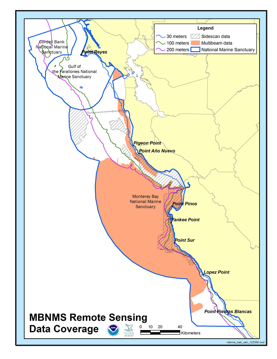
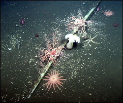
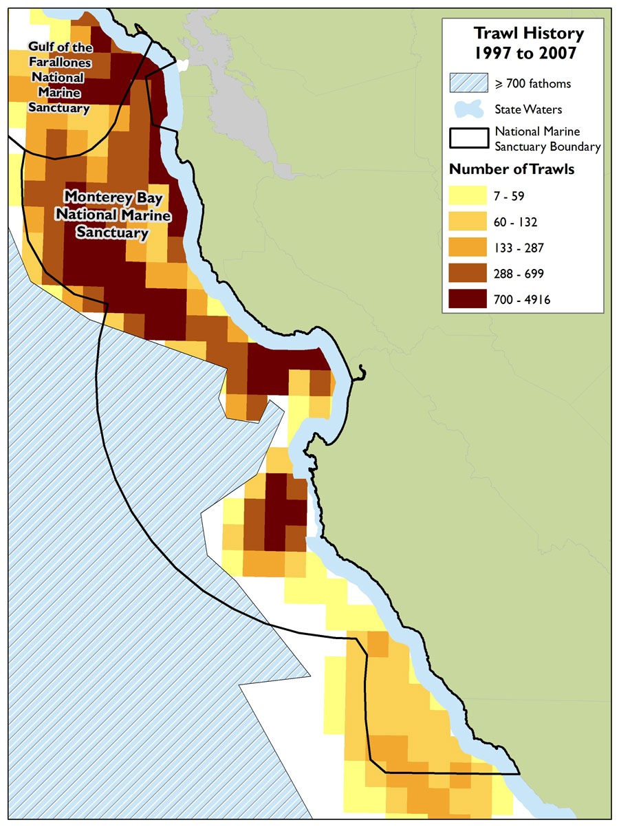
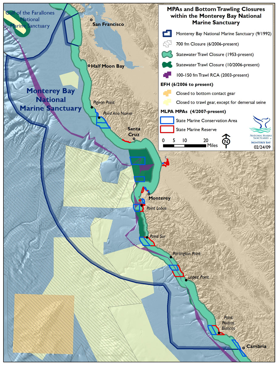
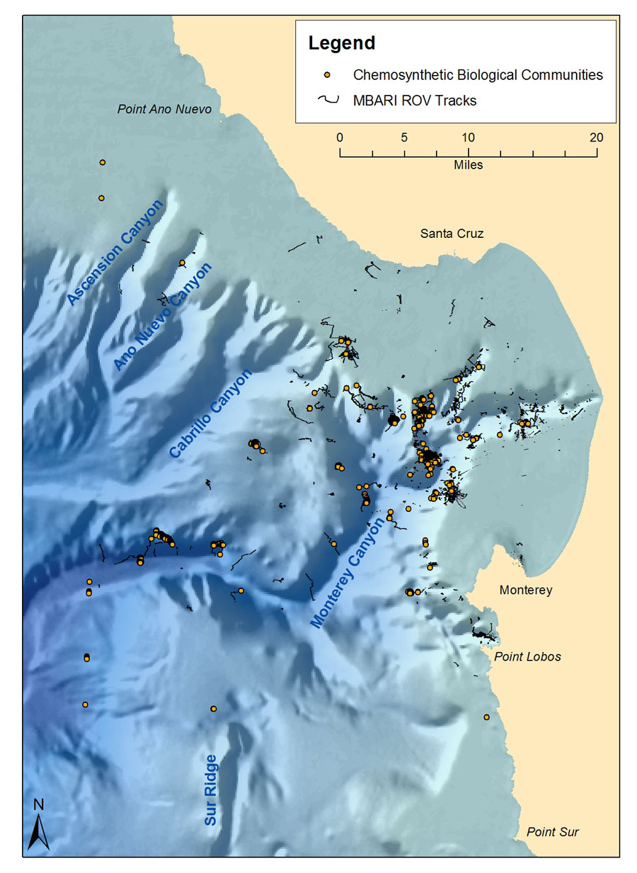
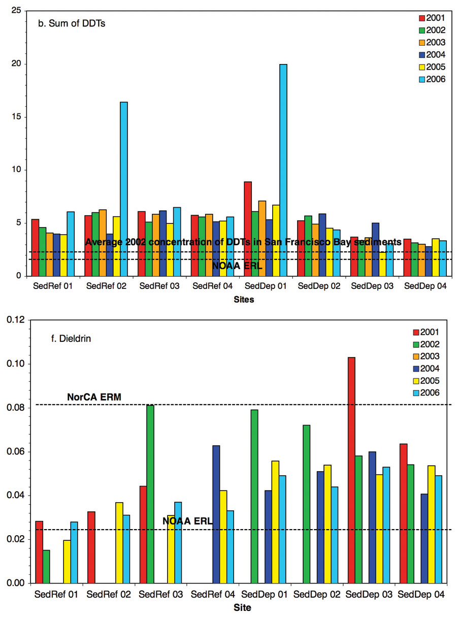
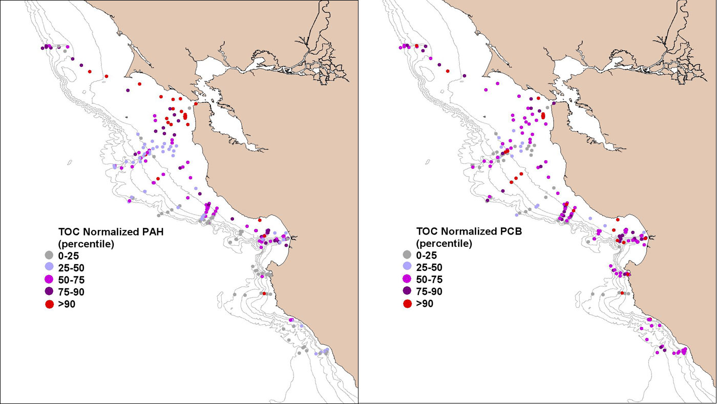
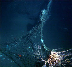
- Conditions do not appear to be changing.
▼ Conditions appear to be declining.
? Undeterminted trend.
N/A Question not applicable.
#
Status
Rating
Basis For Judgement
Description of Findings
5.
Abundance/Distribution
Benthic habitat loss and modification due to fishing with bottom-contact gear; recovery of seafloor habitats resulting from management measures is unknown.
Selected habitat loss or alteration may inhibit the development of assemblages, and may cause measurable but not severe declines in living resources or water quality.
6.
Structure
Damage to and loss of structure-forming and structure-building taxa due to trawl fishing; recovery of biogenic habitat resulting from management measures is unknown.
Selected habitat loss or alteration has caused or is likely to cause severe declines in some but not all living resources or water quality.
7.
Contaminants
![]()
No evidence of strong ecosystem level effects; no attenuation of persistent contaminants in sediments; continued input and delivery of some contaminants to deep-sea habitats.
Selected contaminants may preclude full development of living resource assemblages, but are not likely to cause substantial or persistent degradation.
8.
Human Impacts
![]()
High levels of previous trawl fishing, but recent reductions in trawling activity. Accumulations of marine debris from land and ocean-based human activities.
Selected activities have caused or are likely to cause severe impacts, and cases to date suggest a pervasive problem.
Offshore Environment Living Resources
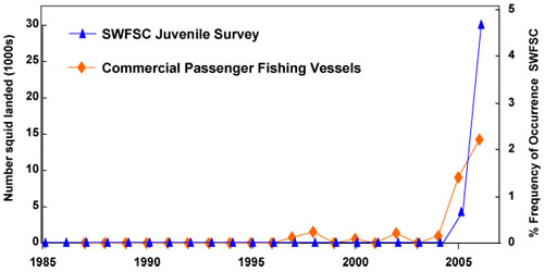
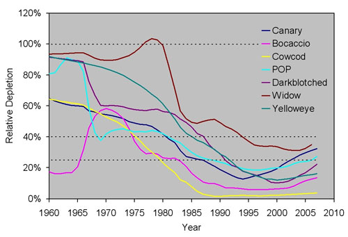
![Figure 42. Monitoring data collected by the Monterey Bay Aquarium Research Institute were used to create time series of anomalies, with higher [or lower] than normal values in red [or blue]. (A) 0 m temperatures have in general remained cool since 1998, resulting in high (C) 60 m nitrate and (D) 0 m chlorophyll (overall phytoplankton biomass) values. However, centric diatoms decreased sharply in 2003 and were apparently replaced by (E) dinoflagellates in 2004. This phytoplankton switch may have been caused by increased (B) near-surface stratification (0-20 m difference in the water density parameter, sigma-t) which resulted from decreased wind-driven upwelling after 2003. Timing of two El Ninos (pink column) and one La Nina (light blue column) are shown. Source: Pennington et al. 2007](images/fig42_lg.jpg)
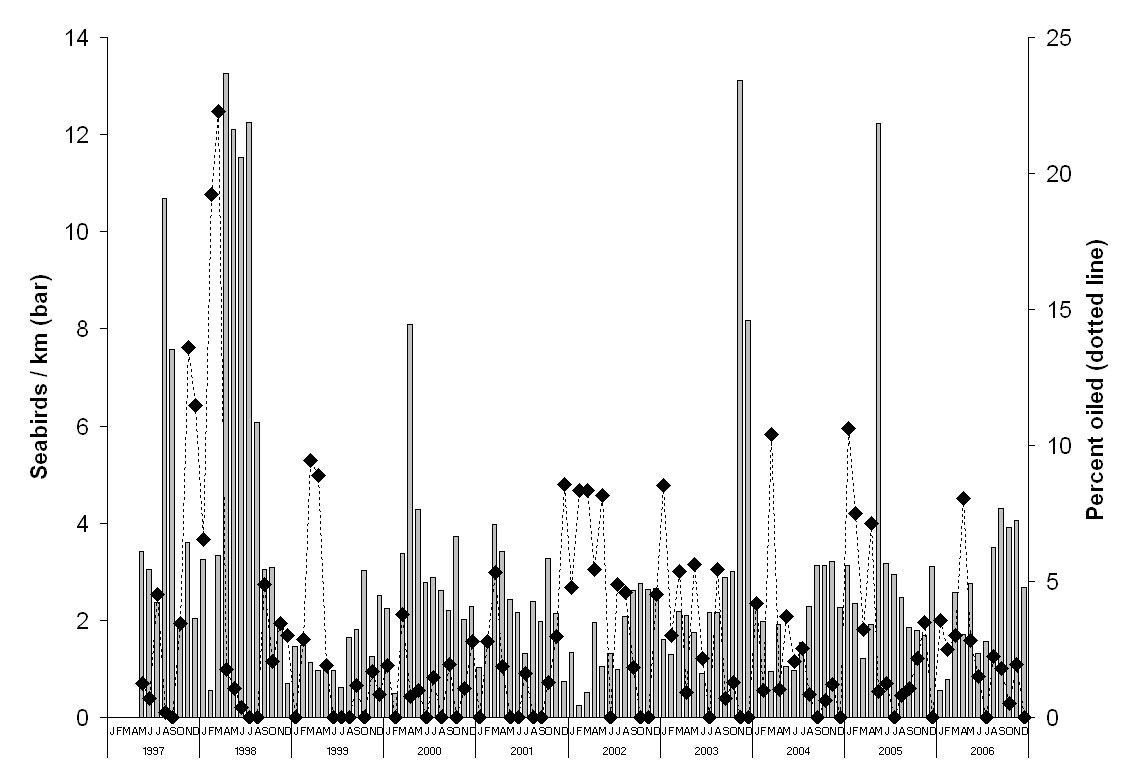
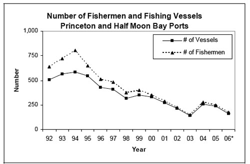
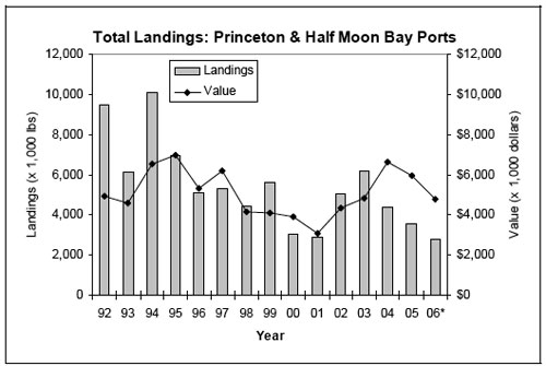
- Conditions do not appear to be changing.
▼ Conditions appear to be declining.
? Undeterminted trend.
N/A Question not applicable.
#
Status
Rating
Basis For Judgement
Description of Findings
9.
Biodiversity
Changes in relative abundance, particularly in targeted, by-catch, and sensitive species.
Selected biodiversity loss may inhibit full community development and function and may cause measurable but not severe degradation of ecosystem integrity.
10.
Environmentally Sustainable Fishing
![]()
Abundance of many harvested species reduced below unfished levels, some targeted and non-targeted species have been drastically reduced by past fishing activity. Fishery management measures have assisted the initial recovery of some overfished groundfish.
Extraction may inhibit full community development and function and may cause measurable but not severe degradation of ecosystem integrity.
11.
Non-indigenous Species
Very few non-indigenous species identified in offshore waters.
Non-indigenous species are not suspected or do not appear to affect ecosystem integrity (full community development and function).
12.
Key Species Status
Reduced abundance of a number of key pelagic species; some reductions caused by activities outside the sanctuary.
Selected key or keystone species are at reduced levels, perhaps precluding full community development and function, but substantial or persistent declines are not expected.
13.
Key Species Condition
![]()
Compromised health due to exposure to neurotoxins produced by HABs, entanglement in active and lost fishing gear, ingestion of marine debris, and accumulation of persistent contaminants.
The condition of selected key resources is not optimal, perhaps precluding full ecological function, but substantial or persistent declines are not expected.
14.
Human Activities
![]()
Fishing and inputs of marine debris have resulted in measurable impacts; recent management actions to reduce marine debris and to recover overfished stocks and impacted habitats.
Selected activities have resulted in measurable living resource impacts, but evidence suggests effects are localized, not widespread.
Offshore Environment Maritime Archaeological Resources


- Conditions do not appear to be changing.
▼ Conditions appear to be declining.
? Undeterminted trend.
N/A Question not applicable.
#
Status
Rating
Basis For Judgement
Description of Findings
15.
Integrity
To date, only one of potentially hundreds of archaeological site inventories has been conducted.
Not enough information to make a determination.
16.
Threat to Environment
![]()
Known resources containing hazardous material continue to deteriorate.
Selected maritime archaeological resources may cause measurable, but not severe, impacts to certain sanctuary resources or areas, but recovery is possible.
17.
Human Activities
Archaeological resources, particularly those that are undocumented, are vulnerable to degradation from trawling.
Some potentially relevant activities exist, but they do not appear to have had a negative effect on maritime archaeological resource integrity.
Nearshore Environment
Nearshore Environment Water Quality
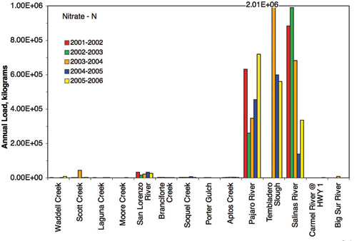
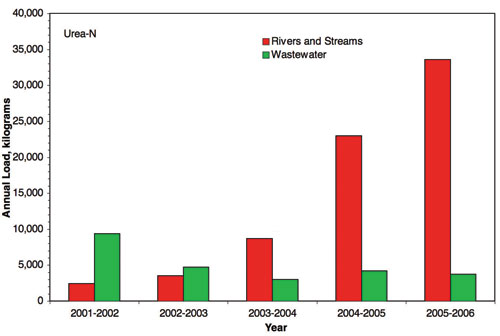
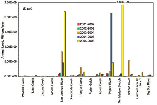
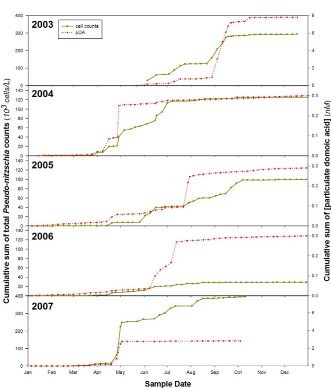
- Conditions do not appear to be changing.
▼ Conditions appear to be declining.
? Undeterminted trend.
N/A Question not applicable.
#
Status
Rating
Basis For Judgement
Description of Findings
1.
Stressors
![]()
Elevated levels of contaminants (e.g., POPs, heavy metals), nutrients, sediments, pathogens in some locations; on-going input of established and emerging pollutants.
Selected conditions may inhibit the development of assemblages and may cause measurable but not severe declines in living resources and habitats.
2.
Eutrophic Condition
![]()
Frequent, localized, and enhanced nutrient enrichment; frequent algal blooms sometimes linked to biotoxin accumulation in fish, birds and mammals.
Selected conditions may preclude full development of living resource assemblages and habitats, but are not likely to cause substantial or persistent declines.
3.
Human Health
Warnings and closures of some beaches and lagoons due pathogen indicators; contaminated shellfish at some locations and during some seasons.
Selected conditions have caused or are likely to cause severe impacts, but cases to date have not suggested a pervasive problem.
4.
Human Activities
Efforts to reduce pollution may be offset by intensification of human activities in coastal watersheds.
Selected activities have resulted in measurable resource impacts, but evidence suggests effects are localized, not widespread.
Nearshore Environment Habitat
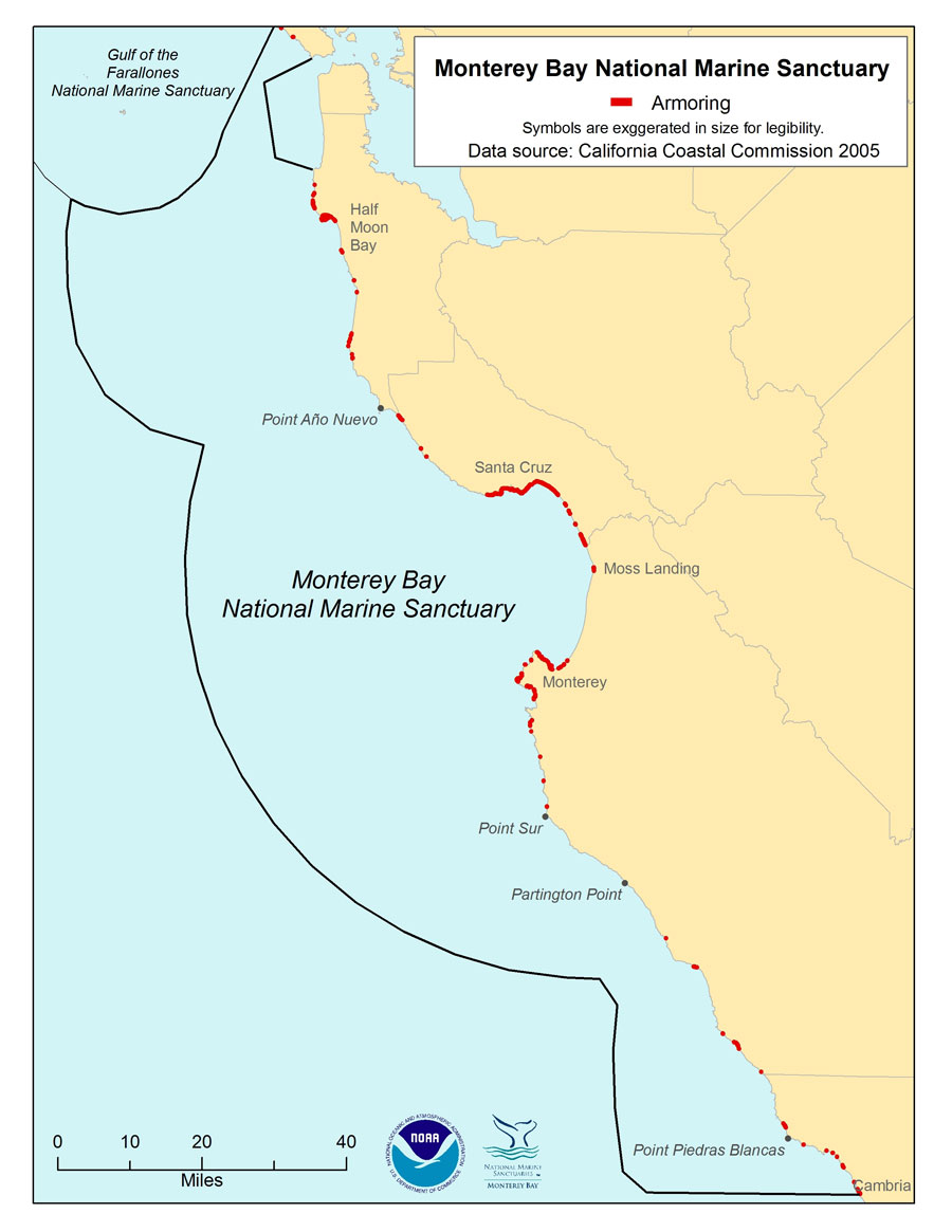
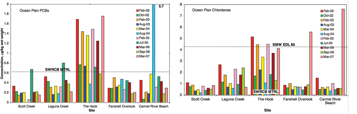
- Conditions do not appear to be changing.
▼ Conditions appear to be declining.
? Undeterminted trend.
N/A Question not applicable.
#
Status
Rating
Basis For Judgement
Description of Findings
5.
Abundance/Distribution

Localized modification or loss of coastal habitat, primarily through armoring of coastal bluff, erosion of sandy shoreline, and landslide disposal on rocky reef.
Selected habitat loss or alteration has taken place, precluding full development of living resource assemblages, but it is unlikely to cause substantial or persistent degradation in living resources or water quality.
6.
Biologically-Structured
Monitoring programs indicate healthy populations and no major perturbations.
Habitats are in pristine or near-pristine condition and are unlikely to preclude full community development.
7.
Contaminants
![]()
Elevated contaminants near urban, maritime, or agricultural activities; continued input of contaminants from point and non-point sources.
Selected contaminants may inhibit the development of assemblages and may cause measurable but not severe declines in living resources or water quality.
8.
Human Impacts
Trampling, all forms of extraction, and sediment disposal can have measurable, localized impacts; cumulative trend for the numerous activities not determined.
Some potentially harmful activities exist, but they do not appear to have had a negative effect on habitat quality.
Nearshore Environment Living Resources

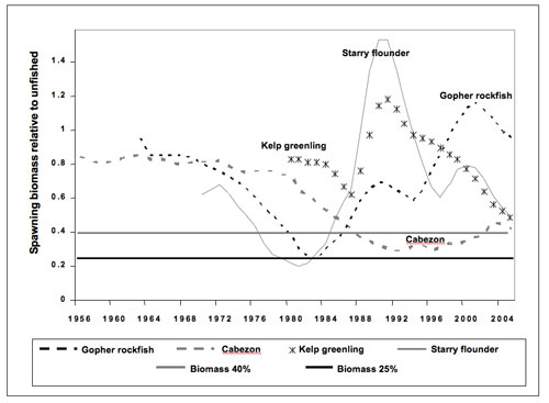
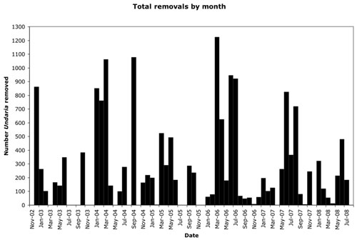
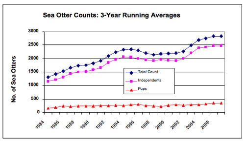
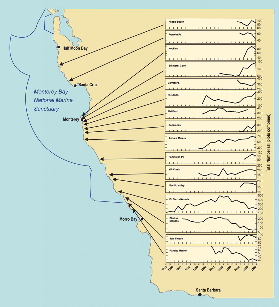
- Conditions do not appear to be changing.
▼ Conditions appear to be declining.
? Undeterminted trend.
N/A Question not applicable.
#
Status
Rating
Basis For Judgement
Description of Findings
9.
Biodiversity
Fishing, collecting, and poaching have reduced overall biodiversity; improvements likely in new protected areas, but continued impacts at some locations on rocky shores.
Selected biodiversity loss may inhibit full community development and function and may cause measurable but not severe degradation of ecosystem integrity.
10.
Environmentally Sustainable Fishing
![]()
Studies have found decreased abundance and size structure in fished areas compared to marine reserves. Restrictive management strategies have improved the status of previously overfished stocks.
Extraction may inhibit full community development and function and may cause measurable but not severe degradation of ecosystem integrity.
11.
Non-indigenous Species
![]()
A few non-indigenous species have been identified, and some appear to be spreading.
Non-indigenous species are not suspected or do not appear to affect ecosystem integrity (full community development and function).
12.
Key Species Status
Abundance of some key species in each habitat type is lower than would be expected in a natural state. Possible community-level impacts on rocky shores.
Selected key or keystone species are at reduced levels, perhaps precluding full community development and function, but substantial or persistent declines are not expected.
13.
Key Species Condition
Evidence of recent impacts from withering syndrome on black abalone. Clear evidence of health problems in sea otters, but limited or no data for other species that may be affected.
The diminished condition of selected key resources may cause a measurable but not severe reduction in ecological function, but recovery is possible.
14.
Human Activities
![]()
Variety of visitation, extraction, and coastal development activities, some of which are increasing in frequency.
Selected activities have resulted in measurable living resource impacts, but evidence suggests effects are localized, not widespread.
Nearshore Environment Maritime Archaeological Resources
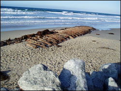
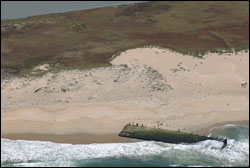
- Conditions do not appear to be changing.
▼ Conditions appear to be declining.
? Undeterminted trend.
N/A Question not applicable.
#
Status
Rating
Basis For Judgement
Description of Findings
15.
Integrity
Divers have looted sites, but not all sites have been studied to determine trend.
The diminished condition of selected archaeological resources has reduced, to some extent, their historical, scientific or educational value and may affect the eligibility of some sites for listing in the National Register of Historic Places.
16.
Threat to Environment
MBNMS Resource Inventory indicates no known environmental hazards.
Known maritime archaeological resources pose few or no environmental threats.
17.
Human Activities
Recreational diving occurs on wreck sites, but activity level is unknown.
Some potentially relevant activities exist, but they do not appear to have had a negative effect on maritime archaeological resource integrity.
Estuarine Environment
Estuarine Environment Water Quality
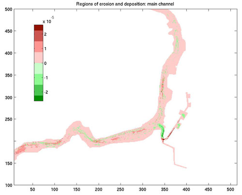
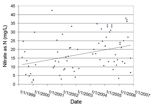
- Conditions do not appear to be changing.
▼ Conditions appear to be declining.
? Undeterminted trend.
N/A Question not applicable.
#
Status
Rating
Basis For Judgement
Description of Findings
1.
Stressors
![]()
Major alternations to tidal, freshwater, and sediment processes has increased the level of pollution and eutrophication; inputs of pollutants from agricultural and urbanized land sources.
Selected conditions have caused or are likely to cause severe declines in some but not all living resources and habitats.
2.
Eutrophic Condition
Low dissolved oxygen levels and high nutrient concentrations are observed but strong tidal flushing dilutes concentrations in main channel.
Selected conditions may inhibit the development of assemblages and may cause measurable but not severe declines in living resources and habitats.
3.
Human Health
Elkhorn Slough and connected waterbodies are impaired by pesticides and pathogens. High levels of contaminants in harvested crustaceans and bivalves could pose a risk to human health.
Selected conditions have caused or are likely to cause severe impacts, but cases to date have not suggested a pervasive problem.
4.
Human Activities
Substantial inputs of pollutants from non-point sources, especially agriculture. Significant efforts over past ten years to implement best management practices and educate local land owners. No evidence yet of improving water quality due to changes in land management practices.
Selected activities have resulted in measurable resource impacts, but evidence suggests effects are localized, not widespread.
Estuarine Environment Habitat
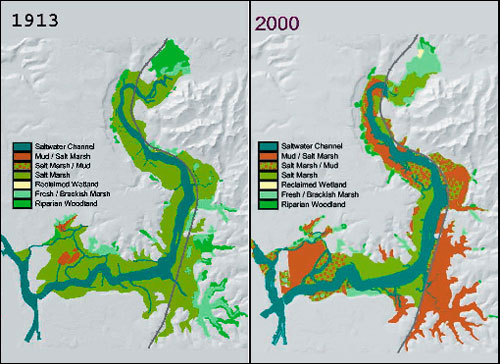
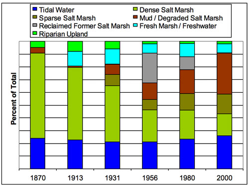
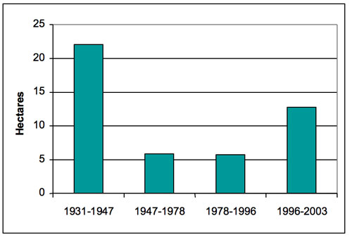

- Conditions do not appear to be changing.
▼ Conditions appear to be declining.
? Undeterminted trend.
N/A Question not applicable.
#
Status
Rating
Basis For Judgement
Description of Findings
5.
Abundance/Distribution
![]()
Over 150 years of hydrologic alteration has resulted in substantial erosion and habitat conversion.
Selected habitat loss or alteration has caused or is likely to cause severe declines in some but not all living resources or water quality.
6.
Biologically-Structured
![]()
Severe reductions in the abundance of native structure-forming organisms from historic levels.
Selected habitat loss or alteration has caused or is likely to cause severe declines in most if not all living resources or water quality.
7.
Contaminants
![]()
Numerous contaminants present and at high levels at localized areas with limited evidence of community level impacts; on-going input of currently applied pesticides and lack of attenuation of legacy pesticides.
Selected contaminants may inhibit the development of assemblages and may cause measurable but not severe declines in living resources or water quality.
8.
Human Impacts
Past hydrologic changes, continued dredging and maintenance of water diversion structures, and input of agricultural non-point source pollution. Management activities have the potential to reduce the input of pollution.
Selected activities warrant widespread concern and action, as large-scale, persistent and/or repeated severe impacts have occurred or are likely to occur.
Estuarine Environment Living Resources
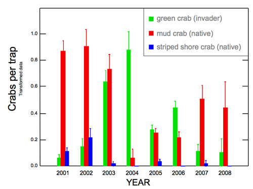
- Conditions do not appear to be changing.
▼ Conditions appear to be declining.
? Undeterminted trend.
N/A Question not applicable.
#
Status
Rating
Basis For Judgement
Description of Findings
9.
Biodiversity
Changes in the relative abundance of some species associated with specific estuarine habitats. Overall trend cannot be determined.
Selected biodiversity loss may inhibit full community development and function and may cause measurable but not severe degradation of ecosystem integrity.
10.
Environmentally Sustainable Fishing
![]()
There is limited take of shellfish and mudflat invertebrates in the lower slough as well as limited fishing and hunting. New state marine protected areas reduce or eliminate fishing.
Extraction takes place, precluding full community development and function, but it is unlikely to cause substantial or persistent degradation of ecosystem integrity.
11.
Non-indigenous Species
High percentage of non-native species, no known recent introductions.
Non-indigenous species have caused or are likely to cause severe declines in ecosystem integrity.
12.
Key Species Status
![]()
Abundance of native oyster, eelgrass, and salt marsh are substantially reduced compared to historic levels; continued loss and conversion of salt marsh.
The reduced abundance of selected keystone species has caused or is likely to cause severe declines in some but not all ecosystem components, and reduce ecosystem integrity; or selected key species are at substantially reduced levels, and prospects for recovery are uncertain.
13.
Key Species Condition
No direct measurements of health or condition have been made for eelgrass and oysters, and salt marsh.
Not enough information to make a determination.
14.
Human Activities
Impacts result from hydrologic modifications, inputs of pollutants from agriculture and development, introduction of non-indigenous species, harvesting, entrainment of larvae in power plant intakes; no clear overall trend in human activities.
Selected activities have caused or are likely to cause severe impacts, and cases to date suggest a pervasive problem.
Estuarine Environment Maritime Archaeological Resources
Status and Trends
- Conditions do not appear to be changing.
▼ Conditions appear to be declining.
? Undeterminted trend.
N/A Question not applicable.
#
Status
Rating
Basis For Judgement
Description of Findings
15.
Integrity
Very little is known for this area.
Not enough information to make a determination.
16.
Threat to Environment
No known environmental hazards.
Known maritime archaeological resources pose few or no environmental threats.
17.
Human Activities
Existing human activities do not influence archaeological resources.
Few or no activities occur that are likely to negatively affect maritime archaeological resource integrity.