Habitat Mapping, Characterization and Dynamics
Conservation Issue
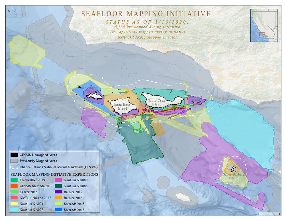
Place-based managers depend on fine-scale bathymetry and habitat maps to make an array of critical decisions, including: navigational safety, disaster response, endangered species and fisheries management, conservation, restoration, research, energy development, and marine spatial planning. In addition, understanding persistence of habitat features is essential to understanding aspects of resilience. Yet in 2021, Channel Islands National Marine Sanctuary (CINMS) is still largely lacking these fundamental decision-making tools.
Description
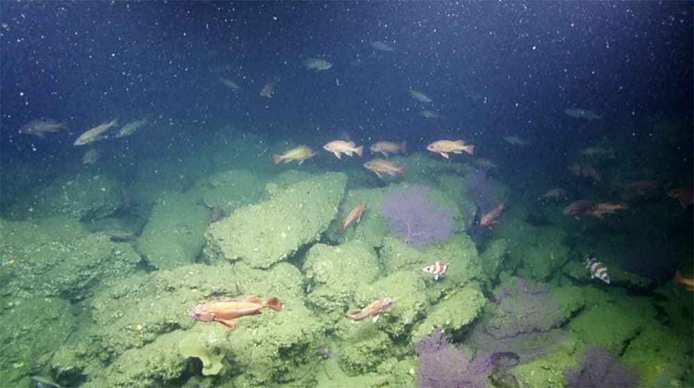
Reliable seafloor maps require acquisition of multi-beam sonar and associated backscatter data for deep areas; LIDAR or other technologies for depths less than 6 meters; and habitat verification using remotely operated vehicles (ROVs), autonomous underwater vehicles (AUVs), diver surveys, and human occupied vehicles (HOVs). Converting these data sets into classified habitat maps will require interpretation of imagery and development of semi-automated classification approaches. Key habitats of interest to the sanctuary include giant kelp; rocky reefs and other hard bottom features that provide substrate for deep-sea corals and sponges; shallow-water kelp communities; eelgrass; surf grass; submerged caves; and soft sediments.
Data and Analysis Needs
- High-resolution multibeam sonar in areas with no data (e.g., around Richardson Rock) and regions where data have proven to be of poor quality
- Topo/bathy LIDAR to cover nearshore areas (<10m) throughout the sanctuary
- Aggregation and further collection of georeferenced underwater imagery for ground truthing and accuracy assessment in support of habitat classification
- Application of semi-automated image classification techniques and machine learning to identify geomorphological structure, biological cover, and benthos type using existing imagery, soundings, and backscatter
- Quantitative, repeatable methods to assess habitat change overtime (e.g., fluctuations in kelp and seagrass distribution, shifts in soft bottom sediments)
Potential Products
- Unified, high-resolution map of seafloor bathymetry to illustrate seafloor topography and complexity
- High-resolution map of seafloor backscatter to determine properties of surficial seafloor sediments
- Individual, high-resolution habitat predictions, depicting where key habitats are likely to occur and the uncertainty associated with those predictions
- High-resolution, classified benthic habitat map denoting common, co-occurring geomorphological structure and biological cover types
- Assessment of performance and accuracy of habitat prediction and classified benthic habitat map
- Report on map performance, map accuracy, and the distribution and extent of habitats, including change over time
Supplementary Information
- 2009 CINMS management plan
- Southern California seafloor mapping initiative: Identifying the gaps and prioritizing future efforts
Sanctuary Integrated Monitoring Network (SIMoN) Resources:
- Southern California seafloor mapping initiative
- Leveraging drones and autonomous boats for mapping and monitoring of shallow-water environments in the Channel Islands
- Investigation of submerged shorelines in the Channel Islands and California Borderland
For more information about this assessment, contact research.CINMS@noaa.gov