
Response to Pressures
This section describes responses to pressures outlined earlier in this document, including specific research, education and outreach activities aimed at protecting sanctuary resources. Responses are based on the sanctuary's management plan that was released in 2009 (TBNMS 2009), as well as initiatives undertaken since that time. The management plan is the result of more than two years of study, planning, and extensive public input and addresses key issues and opportunities affecting the sanctuary.9
Partners in Preservation
The sanctuary relies heavily on the work of others to help respond to pressures on its resources. Many groups and individuals impart energy, expertise, and equipment critical to sanctuary resource protection. Leveraging these partnerships is critical to the sanctuary's successful and sustained management of its resources. Still other partners have their own research objectives, aimed at both cultural and natural resources, and the sanctuary actively supports these efforts.
A research partner's presence in Alpena also has an important effect on the local economy, further strengthening the sanctuary's tie to the community. In 2011, 98 individuals spent 278 overnight stays in the Alpena area in support of sanctuary-related work.
Sanctuary research partners include:
- Cooperative Institute for Ocean Exploration, Research and Technology
- Dr. Robert Ballard's Institute for Exploration
- East Carolina University, Program in Maritime Studies
- East Carolina University, Diving and Water Safety Program
- Grand Valley State University, Annis Water Resources Institute
- Great Lakes Naval Memorial and Museum
- Michigan Department of Environmental Quality
- Michigan Department of National Resources
- Michigan Underwater Preserve System
- National Association of Black Scuba Divers
- NOAA, Great Lakes Environmental Research Laboratory
- NOAA, National Geodetic Survey, Remote Sensing Division
- NOAA, National Undersea Research Center
- NOAA, Office of Coast Survey, Navigation Response Team
- Noble Odyssey Foundation
- PAST Foundation
- University of Connecticut, Marine Sciences Program
- University of Michigan, Anthropology Department
- University of Michigan, Geomicrobiology Lab
- University of Michigan, Marine Hydrodynamics Lab
- University of Michigan, Naval Architecture and Marine Engineering
- University of Michigan, Perceptual Robotics Lab
- University of North Carolina, Coastal Studies Institute
- University of Rhode Island, Joint Program in History/Archaeological Oceanography
- University of Texas at Austin, Applied Research Lab
- University of Vermont, The Rubenstein School of Environment and Natural Resources
- University of Wisconsin-Stout, Biology Department
- U.S. Naval Sea Cadets-Great Lakes Division
- U.S. Coast Guard-Alpena Station
- Woods Hole Oceanographic Institution
Research and Characterization: A Foundation for Responding to Pressures
Research and characterization form the foundation of the sanctuary's resource protection efforts, and underpin responses to specific pressures. Characterization is the process through which resources are located, inventoried, assessed and ultimately analyzed within a broader historical, archaeological and resource management context. Characterization makes informed resource protection possible because it widens the view for resource managers, allowing research efforts to be prioritized and balanced against staff, budget and operational realities.
Characterization is accomplished through a variety of research methods. From archival research to remote sensing and individual site assessment and documentation, research forms the foundation for responding to pressures on sanctuary resources. Archaeological and historical research is also at the heart of the sanctuary's exhibits, education initiatives and public programming, all of which is designed to foster greater awareness and appreciation for the Great Lakes and their rich maritime history. Notably, much of the sanctuary's research is made possible with grants and other outside funding - since 2005, the sanctuary has obtained more than $435,000 from external sources for on-water research and resource protection, greatly supplementing its core resource protection budget.
Thunder Bay Sanctuary Research Collection
Characterization of the sanctuary and its resources begins with an inventory of known and potential maritime archaeological resources in the region. The inventory is based on archival research of contemporary newspapers, lifesaving station and ship logs, vessel enrollments, insurance and court records, and other published and unpublished literature.Much of this research is conducted in the Thunder Bay Sanctuary Research Collection , itself an important sanctuary resource requiring preservation and management efforts. Managed jointly by the sanctuary and the Alpena County George M. Fletcher Public Library, the Thunder Bay Research Collection is a large and unique archival collection dedicated to Great Lakes maritime history. The heart of the collection was amassed over more than 40 years by historian C. Patrick Labadie. Labadie and his wife June contributed the collection to the sanctuary in 2003. Since that donation, dozens of other donors have fortified the collection, and a partnership with the University of Wisconsin-Superior's Jim Dan Hill Library has enhanced the collection's 20th-century holdings.
The collection now includes more than 1,000 published works, 80,000 photographs, 56 linear feet of vertical files, 40 feet of periodicals, 100 navigation charts, 350 shipbuilding plans, various manuscripts, and files on more than 20,000 Great Lakes watercraft. The collection also contains information on Great Lakes ports, cargos, ship owners and captains, ship technology, and archaeology. Because it is a significant sanctuary resource and open to the public, a major focus has been to digitize the collection. A $235,000 grant from the Michigan Department of History, Arts, and Libraries, nearly $160,000 from the NOAA Climate Database Modernization Program and hundreds of volunteer hours made possible the creation of an online database of 17,000 vessels and related photographs. Digitization accelerates the pace of historic research, fosters greater public access to the collection, and aids in the preservation of fragile documents by reducing the need for direct physical handling (TBNMS 2009).
Locating Maritime Archaeological Resources
Physically locating maritime archaeological sites is the next step in sanctuary characterization and resource protection. Remote sensing surveys have been undertaken within the sanctuary and surrounding waters with assistance from NOAA, universities and other partners. As of 2011, 361 square miles have been surveyed within the sanctuary's current 448-square-mile boundary. An additional 246 square miles have been surveyed outside the sanctuary's boundaries. Since designation, the sanctuary has discovered and identified five intact shipwreck sites at depths between 160 and 300 feet, as well as hundreds of targets in shallow water representing the scattered remains of an undetermined number of shipwrecks and other historic features such as pound net stakes, pilings and cribs.A major side-scan sonar survey covering approximately 240 of the sanctuary's 448 square miles was undertaken in 2001 (the year following sanctuary designation) by Robert Ballard's Institute for Exploration. The team confirmed the locations of 15 sites in and around the sanctuary, produced the sanctuary's first sonar images of these sites, and discovered the wreck of the schooner Corsican (1862-1893; 160-foot depth) and a submerged sinkhole in 300 feet of water. Significantly, the effort covered nearly half of the sanctuary's area, primarily offshore, allowing future remote sensing efforts to focus on relatively easier to survey nearshore areas.
In partnership with the University of Rhode Island, and bolstered with funding from NOAA's Office of Ocean Exploration and Research, three seasons of side-scan sonar surveys have resulted in an additional 109 square miles of coverage both within and beyond the sanctuary's boundaries. The team discovered the wreck of the steamer Messenger (1866-1890; 190-foot depth) in 2008. Earlier efforts, conducted as graduate-level field schools, focused on the shallow waters around Thunder Bay Island, Sugar Island and North Point Reef, resulting in more than 200 targets of interest in a three-square-mile area.
NOAA Office of Ocean Exploration and Research grant funding has been instrumental in making possible two other major surveys. In 2010, a team from the sanctuary and the University of Michigan's Anthropology Department set out to search for prehistoric archaeological sites along the Alpena-Amberley Ridge. Around 7,500 years ago, this now-submerged land bridge spanned northern Lake Huron, connecting Michigan and Canada. Working 50 miles offshore with a multibeam sonar temporarily installed on the sanctuary's R/V Storm, the team mapped 46 square miles of lake bottom. The effort allowed University of Michigan anthropologists to model a portion of the land bridge and make better predictions as to where prehistoric people may have lived and hunted, which in turn has focused subsequent research. Additionally, in 2010, the sanctuary and the Applied Research Lab at University of Texas-Austin surveyed 104 square miles in and around the sanctuary. Using forward-looking sonar developed by the Applied Research Lab mounted on a REMUS 600 autonomous underwater vehicle, the team discovered the wreck of the steamer Egyptian (1873-1897; 240-foot depth), as well as other targets of interest in shallower water (Figures 53 and 54).

In 2011, the sanctuary added to its remote sensing infrastructure a RESON 8101 multibeam sonar, surplused from NOAA's Office of the Coast Survey. Now installed permanently on the R/V Storm, the sonar was used in 2011 to survey 70 square miles off Presque Isle, Mich. Much of the surveying took place during the Sony- and Intel-funded Project Shiphunt, which brought five Saginaw, Mich., high school students to the sanctuary to search for a historic wreck and work alongside researchers from NOAA and the Woods Hole Oceanographic Institution. The team discovered the wrecks of the Etruria (1902-1905; 300 foot-depth) and schooner M. F. Merrick (1863-1889; 300-foot depth).

An important by-product of sonar surveys designed to locate shipwrecks is the production of bathymetry and maps that can be used by scientists interested in the sanctuary's natural resources. Although not all sonar data is useful for this purpose, the sanctuary is acquiring an ever-increasing amount of this data type. For example, in partnership with the sanctuary, NOAA's Office of the Coast Survey has been surveying with multibeam and side-scan sonar much of Thunder Bay proper, producing approximately 40 square miles of highly detailed bathymetry maps as of 2011. The project's aim is to map the entirety of Thunder Bay and the waters south of Sugar and Thunder Bay Islands by 2013 (Figure 55). The effort was undertaken primarily to update NOAA nautical charts for the area, but it has also proven effective at producing the first detailed bathymetric maps of Thunder Bay. As it becomes available, the data is shared with researchers at the Michigan Department of Natural Resources and the Environment, U.S. Fish and Wildlife Service, U.S. Geological Survey, and NOAA Great Lakes Environmental Research Lab, all of which are conducting research and monitoring in Thunder Bay. Additionally, the data helped scientists plan fieldwork for the 2012 Lake Huron Coordinated Sampling Initiative, much of which focused on Thunder Bay.10
The R/V Storm and NOAA's Green Fleet in the Great Lakes
Much of Thunder Bay sanctuary's research is accomplished with the use of the R/V Storm. Originally built in 1992 as a United States Coast Guard prototype, the Storm served in Baltimore, Md., and later at the U.S. Merchant Marine Academy in Long Island, N.Y. Acquired on surplus and extensively refitted in 2009 by the NOAA Great Lakes Environmental Research Lab (GLERL), the 50-foot vessel is another "Green Ship" in NOAA's Great Lakes fleet.
The Storm's B100 fuel is produced from soy bean oil and reduces emissions by more than 70 percent. Engine oil, lubricants and hydraulic oils are manufactured from a variety of vegetable oils. These biomaterials are sustainable and far less toxic than conventional petroleum oils. The focal point of the Storm's green attributes is its low rebuild carbon footprint. Through careful engineering and creative use of recycled materials, the 18-year-old vessel was rebuilt to add value and extend its useful life. For its "Green Ship" innovations, GLERL has been awarded the U.S. Department of Energy's "You Have the Power" Award.
The sanctuary has also facilitated the use of other types of remote sensing technology. In 2006, leveraging assets from NOAA's Remote Sensing Division, the sanctuary used aerial-borne topographic LIDAR (Light Detection and Ranging) to map the shoreline around Thunder Bay, and also produced high-resolution photogrammetry to about the 18-foot depth contour. Similar to radar but using light pulses instead of radio waves, LIDAR is typically "flown" or collected from planes and produces a rapid collection of points (more than 70,000 per second) over a large collection area, with resolution to about one meter. The project was successful in that the locations of several shallow-water shipwreck sites were confirmed via photogrammetry. Information such as this helps bridge the gap between marine and terrestrial environments, and is useful for shoreline communities as they seek better data to assist with planning. The data also establishes a baseline for comparing historical and archival information on the dynamic maritime landscape of the city of Alpena over time, which includes changes to the waterfront and fluctuations in commercial structures.
Supplementing high-tech acoustic remote sensing surveys, particularly in shallow water, are visual surveys done by divers or even topside from a shallow-draft research vessel. Surveys of this type have been especially productive on North Point Reef, where nearly 70 vessels stranded since the middle of the 19th century. Although the majority of vessels were ultimately recovered, about a dozen remain on the reef. A visual survey in 2004 by sanctuary staff recorded more than several dozen targets on the reef. In 2005, a team of graduate students from East Carolina University's (ECU) Program in Maritime Studies focused on creating a site plan for wreckage thought to belong to the propeller Galena (1857-1872; 16-foot depth), stranded on the reef in 1872. Galena was lost not far from the propeller Congress(1861-1868; 17-foot depth) and the steam barge B.W. Blanchard (1870-1904; nine-foot depth), as well as the schooners John T. Johnson (1873-1904; seven-foot depth), Empire State (1862-1877; 12-foot depth) and E.B. Palmer (1856-1892; 16-foot depth). Wreckage from some or all of these vessels was located during the visual survey in 2004 and re-examined during the ECU field school. In total, 41 sites consisting of large sections or clusters of wreckage, anchors, rudders, windlasses and even a lifeboat davit were recorded with basic measurements, scaled drawings and photographs.11 These targets, as well as those obtained during other visual and acoustic surveys are prioritized, managed and stored in the sanctuary's geographic information system.

Finally, new research by the University of Michigan aims to determine the archaeological potential of the Alpena-Amberley Ridge (Figure 56), a now-submerged land bridge that once connected Michigan with Canada. Roughly 9,900 - 7,500 years ago, the ridge formed a dry land corridor extending across Lake Huron from Presque Isle in northeast Michigan to the Point Clark area in southern Ontario. This land bridge would have provided a natural causeway for the migration of caribou and valuable terrain for hunters seeking to exploit the herd. Pilot research by the University of Michigan's Department of Anthropology suggests that stone features potentially used by Arctic caribou hunters are preserved on the ridge and can be recognized using acoustic mapping. In 2010, the sanctuary assisted with mapping 44 square miles of the ridge, identifying significant targets and generating enough bathymetry data to produce a dynamic 3D model. In 2011, the team made 61 dives to "ground truth" many of the sonar targets.
In 2012, the Noble Odyssey Foundation, a longtime sanctuary partner, continued visually surveying prehistoric drowned forest remains from a range of depths in the Thunder Bay area. With assistance from U.S. Naval Sea Cadet divers, the team expanded its understanding of an area discovered in 2010 through the discovery of additional tree stumps 22 feet below the present lake level. Radiocarbon dating by the University of Arizona reveals that the stumps at this depth contour are 7,000-8,000 years old. The ages of wood from different depths in Thunder Bay will indicate how fast lake levels were rising during that period. Equally significant is the potential for prehistoric cultural material to be located along these ancient shorelines.
Site Assessment and Documentation

Once archaeological sites are located, they are assessed and documented. Site location, integrity and depth generally dictate the methodology and equipment with which a site is assessed and later documented archaeologically. Assessments provide baseline data to evaluate a site's current state of preservation and plan and prioritize future documentation and permanent mooring installations. It also allows for the initial identification of threats to sites, such as invasive mussel coverage, natural deterioration, anchor damage, looting and other impacts. Sanctuary staff have conducted field assessments at 44 of the 45 known shipwreck sites within the sanctuary's current 448-square-mile boundary. Of the 47 known wrecks in the proposed expansion area (see Site Historyand Going Forward: Sanctuary Boundary Expansion sections), the sanctuary has conducted field assessments at 32 sites. Assessments are conducted using various methods and data, including diver observations, sonar images, video and still imagery acquired by remotely operate vehicles (Figure 57).
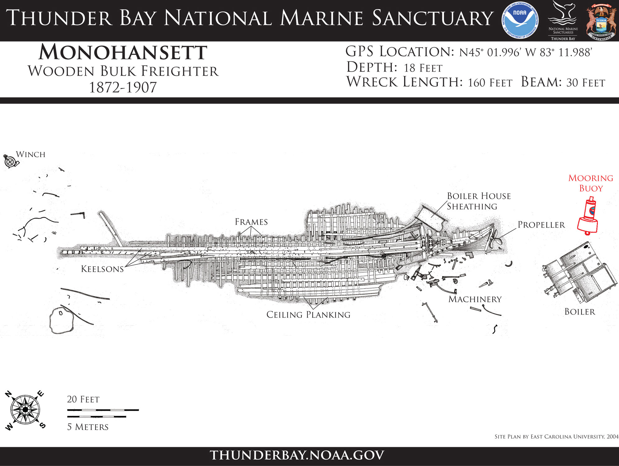
Detailed archaeological documentation is generally conducted with trained divers manually mapping wreck sites. Divers can be sanctuary staff, university and other partners, or volunteers. Many partners and volunteers have had sanctuary-sponsored training in archaeological methods (see Education and Outreach section). In 2011, the sanctuary and its partners made more than 350 dives in support of sanctuary research and resource protection projects. Using manual mapping techniques, the sanctuary and its partners have produced archaeological site maps for 24 shipwrecks in and around the sanctuary (Figures 58 and 59). The maps capture a site's state of preservation, establish baseline data from which to monitor and manage future impacts to the site, provide archaeological data to researchers, and serve as the basis for a number of outreach products. This type of documentation has occurred at popular shipwreck sites such as the Grecian (1891-1906; 100-foot depth), E. B. Allen (1864-1871; 100-foot depth), New Orleans(1838-1849; 13-foot depth), Shamrock (1875-1905; 11-foot depth), andMonohansett (1872-1907; 18-foot depth), as well as other shallow-water shipwreck sites near North Point, Whitefish Point, Isaacson Bay, Forty-Mile Point and Black River.

Given the popularity of technical diving (using specialized equipment to dive deeper than 130 feet) and the pressures that can be exerted on the exceptional resources at these depths, the sanctuary and its partners are increasingly assessing and documenting shipwrecks at depths between 130 and 300 feet (Figures 60 and 61). Many of these sites are located outside the sanctuary's current boundaries and possess significant preservation and archaeological integrity (see Site History and Resources section). In 2001, Robert Ballard's Institute for Exploration laid the groundwork by obtaining high-definition video at many of these sites with remotely operated vehicles (ROVs), Little Hercules and Argus. The University of Michigan'sM-Rover has also been used to capture dozens of hours of video. Since 2005, sanctuary archaeologists have used mixed-gas diving and decompression techniques to access these complex sites.
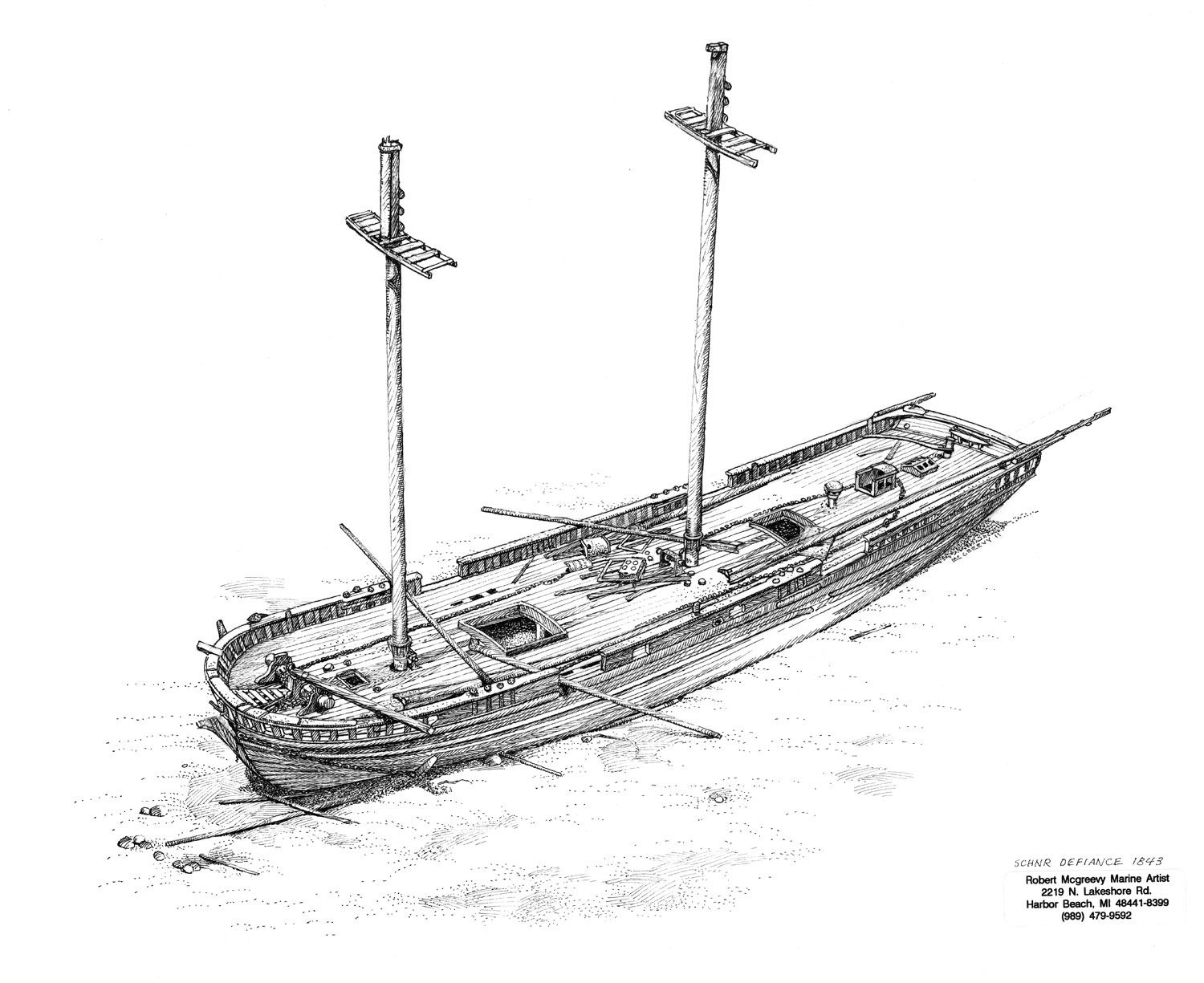
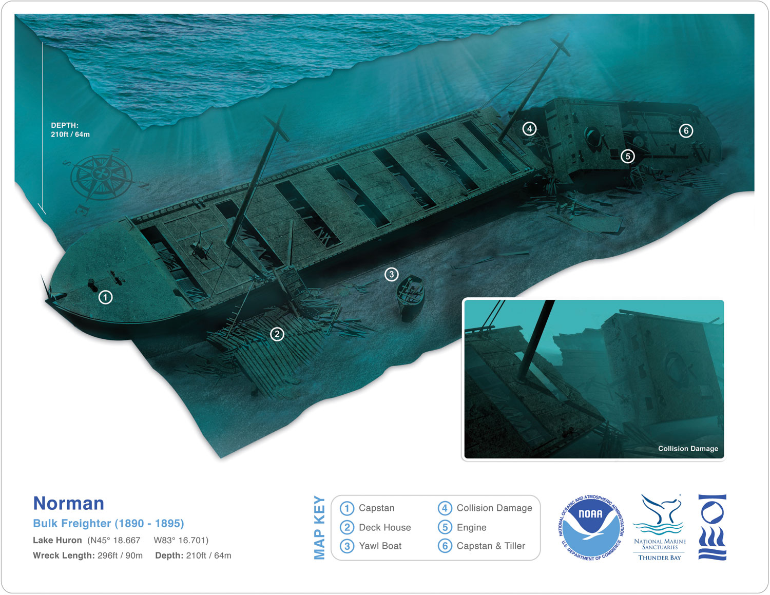
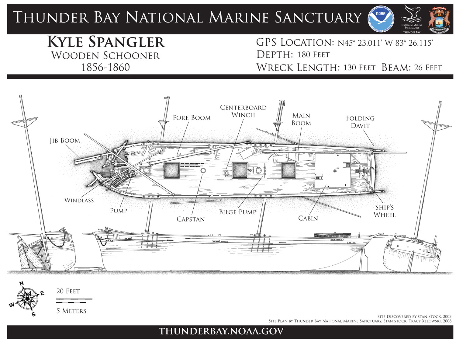
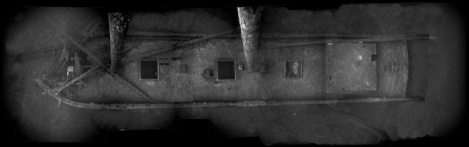
Using a variety of data, assessments have been conducted at 17 shipwrecks in technical depth ranges, including popular sites such as the John J. Audubon (1854-1854; 170-foot depth), Florida (1889-1897; 200-foot depth), New Orleans (1885-1906; 130-foot depth), Norman (1890-1895; 220-foot depth), Typo (1873-1899; 160-foot depth), F. T. Barney (1856-1868; 160-foot depth), and Monrovia (1943-1959; 140-foot depth). With the help of partners, assessments have also occurred at the recently discovered sites Egyptian (1873-1897; 240-foot depth), Etruria(1902-1905; 310-foot depth), M. F. Merrick (1863-1889; 300-foot depth) andMessenger (1866-1890; 195-foot depth). More detailed documentation has occurred at the Corsican (1862-1893; 160-foot depth), Defiance (1848-1854; 185-foot depth), Kyle Spangler (1856-1860; 185-foot depth) and Pewabic (1863-1865; 160-foot depth). The assessment of deepwater shipwrecks is significantly enhanced by contributions from skilled volunteer technical divers willing to contribute their video, still images and site observations.
Notably, the sanctuary is also an excellent training ground for students studying maritime history and archaeology, and those efforts contribute to the sanctuary's ability to document maritime archaeological sites (Figures 62 and 63). The sanctuary has hosted field schools for students from East Carolina University, University of Rhode Island and University of Michigan.

Toward a Better Understanding of Thunder Bay
Although sanctuary regulations pertain only to maritime archaeological resources, the sanctuary is dedicated to facilitating scientific research and monitoring that improves our understanding of Lake Huron's natural resources. Beyond data sharing, such as bathymetry maps produced during sanctuary remote sensing operations, the sanctuary regularly provides scientific diving, research vessel, housing, lab support and workspace for a variety of multidisciplinary projects.
Reef Restoration
Since 2008, the sanctuary has provided planning, logistical, diving and research vessel support for the Thunder Bay Reef Restoration project, coordinated by the Michigan Department of Environmental Quality. Nearly 1.5 acres of new reef habitat have been created along the eastern shores of Alpena, with the goal of mitigating the loss of natural reef habitat from previous decades of cement kiln dust disposal. A total of 29 individual reefs have been placed near two existing natural reefs. The project is made possible by a grant from the Estuary Restoration Act (NOAA) Estuary Habitat Restoration Program in conjunction with the United States Army Corps of Engineers and the donation of more than 13,000 tons of limestone cobble by Lafarge - Alpena Plant.
A Window into Earth's Past
In an ongoing effort to support and facilitate multidisciplinary research at the Middle Island submerged sinkhole, the sanctuary's research team regularly conducts scientific dives for researchers from Grand Valley State University's Microbial Biology Lab, the University of Michigan's Geomicrobiology Lab, the University of Wisconsin-Stout, and NOAA's Great Lakes Environmental Lab as they continue to characterize the specialized ecosystem present at the Middle Island sinkhole. At this sinkhole location, colorful microbial mats with bubbling gasses have been discovered which are not found anywhere else in the Great Lakes, and are known to occur in just a few other places on Earth (Biddanda et. al 2012). Recent genetic research suggests that the sinkhole's modern bacteria are 2.5 billion-year-old cousins to some of Earth's first oxygen-using organisms.
Keeping an Eye on the Weather
In 2004, the Thunder Bay sanctuary and NOAA's Great Lakes Environmental Research Lab (GLERL) placed an Integrated Coastal Observing System buoy in the sanctuary at the shipwreck Montana, nine miles from shore. The buoy is equipped with a host of sensors that provide real-time meteorological data, such as air temperature, wave height and direction, wind speed and direction, and temperatures throughout the water column. The sanctuary and GLERL also mounted a meteorological station at the entrance to the Thunder Bay River. This station provides real-time weather data and has a camera that continuously generates three real-time views of Thunder Bay. Both observing systems are used regularly by commercial and recreational boaters in Thunder Bay.<
Specific Responses to Pressures: Diving and Looting
The sanctuary encourages public access to its resources and strives to balance increased visitation with resource protection. The following outlines management responses to the pressures on sanctuary resources that were outlined earlier in this report.
Shipwreck Moorings
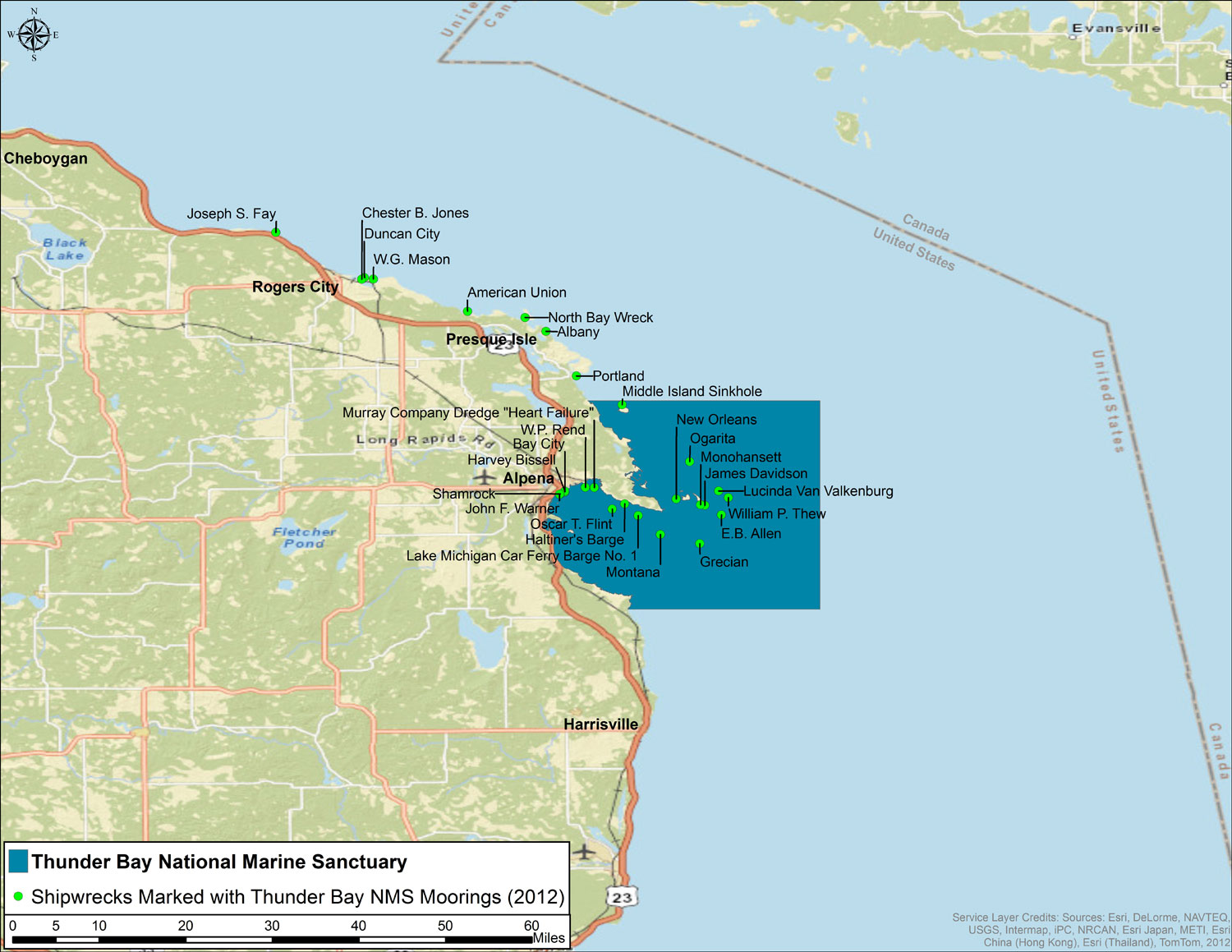
As indicated earlier in this report, there are photographic evidence and diver reports of disturbance at sanctuary shipwreck sites due to human activities. Both divers, as well as dive boats, can negatively impact sanctuary resources. To eliminate anchor damage to shipwrecks sites, the sanctuary installs and maintains a growing number of permanent moorings at popular sites (Figures 64-66). The first system was installed in 2003. Currently, 27 sites are marked with U.S. Coast Guard-approved moorings, and the sanctuary has approved permits for 30 new sites. Moorings also eliminate the need for non-permitted moorings at shipwreck sites, which can become derelict over time, posing a risk to divers and potentially damaging the site. Finally, moorings encourage public accessibility and make for safer diving by providing a sturdy means of descent and ascent for divers, and an easy-to-find surface marker for kayakers. Mooring buoys are installed and recovered seasonally to avoid ice and storm damage during winter months. Moorings are typically available from May 15 through Oct. 1, but weather can occasionally delay seasonal redeployments. The sanctuary's website provides divers with the up-to-date status of each mooring. Sanctuary regulations prohibit the use of grappling hooks or other anchoring devices on maritime archaeological resource sites if a mooring buoy is available at the site (TBNMS 2009).
Education and Outreach
Ultimately, resource protection is a shared responsibility between the sanctuary and a wide range of stakeholders. At the front lines of this effort are divers who visit sanctuary sites directly. Fostering appreciation for sanctuary resources among divers is fundamental to reducing human impacts at these unique, irreplaceable sites. Divers, and other stakeholders, will protect what they value. Through focused education and outreach the sanctuary strives to articulate the message that the shipwrecks of Thunder Bay are historical, archaeological and recreational sites worth protecting. The sanctuary conducts substantial education and outreach activities designed to reach multiple audiences including educators, students, tourists and the local community, among others.12 Although divers benefit from all of the sanctuary outreach efforts, this section of the report identifies efforts directed chiefly at divers, with the express purpose of fostering a preservation ethic.National and regional diving trade shows, maritime archaeological workshops and academic symposiums are important venues to meet with divers. These provide opportunities to discuss concerns in the dive community, reinforce the benefit of responsible diving through presentations and outreach literature, and build partnerships. Since 2004, sanctuary archaeologists have staffed informational booths and given presentations at many regional and national venues, includingGales of November (Duluth, Minn.), Dive into the Past (Minneapolis/St. Paul, Minn.), Ghost Ships Festival (Milwaukee, Wisc.), Our World Underwater (Chicago, Ill.), Great Lakes Shipwreck Festival (Ann Arbor, Mich.), Boston Sea Rovers(Boston, Mass.), and the Society for Historical Archaeology Annual Conference(various national locations). Sanctuary staff attend several of these events annually. In 2011, sanctuary archaeologists gave presentations and staffed informational booths at three major Midwest diving trade shows with an overall attendance of over 11,000
Reaching a wider diving audience is also important, as the sanctuary seeks to deliver its preservation message via larger outlets and promote diving and tourism in the region. Since 2004, the sanctuary has facilitated and been featured in a number of television and film projects aimed at both diving and general audiences. These include: History Channel (Deep Sea Detectives: Great Lakes Ghost Ship), Jean-Michel Cousteau's Ocean Futures Society (America's Underwater Treasures), National Geographic Channel (Drain the Great Lakes), Radical Media/Current TV (Project Shiphunt), Discovery Channel Canada (Daily Planet), the Science Channel (Great Lakes Shipwrecks), and public television (Tragedies in the Mist).
Creating an increased sense of value toward sanctuary resources requires providing meaningful products that both facilitate public access and reinforce responsible diving. Consequently, many of the sanctuary's research products are repurposed as outreach material specifically for divers. For example, 17 of the sanctuary's archaeological site maps can be downloaded and printed via the sanctuary's website, and several have been rendered as computer animations and 2D graphics for dive planning (Figures 67 and 68). Divers can access these on the sanctuary's website, where they will also find coordinates, images and diving-related information on 69 shipwrecks in and around the sanctuary.

Involving divers directly in the documentation of shipwreck sites helps foster a preservation ethic, while also expanding the sanctuary's research abilities. Using the Nautical Archaeology Society's curriculum and certification, the sanctuary has trained 69 divers in archaeological field methods.13 During this hands-on archaeological training experience, students learn about historic preservation, maritime archaeological law and sanctuary-specific resource protection efforts. These "citizen scientists" include local residents, as well as members of the Michigan Underwater Preserve Council, Michigan State Police, U.S. Naval Sea Cadets and National Association of Black SCUBA Divers (Figure 69).
Similarly, in recent years the sanctuary has actively developed partnerships with skilled volunteer technical divers, a subset of the diving population that uses advanced diving methods to access the Thunder Bay region's many intact deepwater shipwrecks. This effort has led to much greater sanctuary exposure within the technical diving community, which in turn advances its resource protection efforts. This was demonstrated in 2011 after the sanctuary's discovery of the schooner Merrick and steamer Etruria, both in approximately 300 feet of water. Located in May during a Sony-funded survey, only limited ROV footage could be obtained due to a short operational and funding window. Just two months later, the sanctuary acquired excellent video and still images of the sites due to the work of skilled volunteers.14 The effort substantially increased the time frame in which the sanctuary can assess the wrecks and plan future documentation (Figures 70 and 71). Additionally, a joint 2008 project between the sanctuary and local technical divers produced high-quality data on the wreck of the Kyle Spangler, which made possible the public release of its location (Figures 72 and 73).


The Great Lakes Maritime Heritage Center
In 2005, Thunder Bay National Marine Sanctuary opened the Great Lakes Maritime Heritage Center (GLMHC), which houses the sanctuary's headquarters, research station and visitor center (Figures 74 and 75). The center provides an opportunity for the sanctuary to enhance public awareness, understanding and stewardship of the sanctuary, the Great Lakes and the ocean. The main components of the 9,000-square-foot exhibit space include a full-size replica schooner and shipwreck, along with a shipwreck gallery, artifact storage and conservation laboratory, visible curatorial space, distance-learning equipped classroom, a researchers' field station, and a 93-seat theater. The center welcomed approximately 70,000 visitors in 2011. Beyond education, the GLMHC serves as the anchor for heritage tourism in the region and has attracted new businesses, such as a glass bottom boat, clear-bottom kayak rentals and a dive shop, all located in the city of Alpena. Through a partnership with the University of Michigan's Institute for Research on Labor, Employment, and the Economy, the sanctuary seeks to quantify the economic impacts of these new activities starting 2012.

Law Enforcement
Preventing artifact looting and other negative human impacts to sanctuary resources requires enforcement of sanctuary regulations and state laws, and a sufficient on-water presence within the sanctuary. To accomplish this, the sanctuary partners with local, state and federal law enforcement agencies including NOAA's Office of Law Enforcement, the U.S. Coast Guard (USCG), Michigan Department of Natural Resources and the Environment (MDNRE), Alpena County Sheriff, and Michigan State Police.In 2011, the USCG Alpena-Station was underway 94 times and logged over 260 hours in and around the sanctuary, including operating at least 15 days near Presque Isle, Mich., an area under study for potential sanctuary expansion and a popular marina for dive boats. Also, the USCG Auxiliary was underway 10 times in the area, operating four times out of Presque Isle. Additionally, a USCG cutter operated in Thunder Bay proper conducting law enforcement operations for one week. This on-water presence constitutes a significant piece of law enforcement for the sanctuary.
The sanctuary is also developing "interpretive enforcement" practices, which seek to enhance compliance primarily through education. The goal of interpretive enforcement is to gain the greatest level of compliance through public understanding and support of sanctuary goals. Interpretive enforcement emphasizes informing the public through education and outreach about responsible behavior before resources are adversely impacted. Law enforcement officers interact with users on the water and at the dock. These encounters allow officers to make direct, informative contacts with visitors and local residents, while conducting routine enforcement activities. Per its 2009 Management Plan, the sanctuary is developing ways to make interpretive enforcement more effective, including regular meetings with the USCG-Alpena Station and its auxiliary unit.
The following activities are prohibited in the sanctuary without a permit:
- Recovering, altering, destroying, or possessing underwater cultural resources.
- Drilling into, dredging, or otherwise altering the lake bottom associated with underwater cultural resources.
- Using grappling hooks or other anchoring devices if a mooring buoy exists.
- Going Forward: Sanctuary Boundary Expansion Section
Facilitating continuing education for local law enforcement officials is an important aspect of sanctuary law enforcement. In 2005, the sanctuary hosted a maritime heritage law enforcement workshop for regional agencies, bringing experts from NOAA's Office of Law Enforcement to Alpena, Mich. In 2006, the sanctuary superintendent and four members of the USCG-Alpena Station and MDNRE attended a submerged cultural resources law enforcement class sponsored by Biscayne National Park. Additionally, maritime heritage law is a key component of the sanctuary's Nautical Archaeology Society training. During these classes, students learn the basics in shipwreck-specific legislation and how it applies to the sanctuary. Members of the Michigan State Police have attended this training. In Alpena in 2009, the NOAA Maritime Heritage Program sponsored a workshop on federal heritage law. The workshop focused on the National Historic Preservation Act's Section 106, which provides a process to ensure that federal activities are reviewed for potential impacts on state lands, in this case submerged bottomlands of the national marine sanctuaries. Attendees included maritime heritage coordinators and other personnel from NOAA's Office of National Marine Sanctuaries.
Coordination and communication among the several agencies involved in sanctuary law enforcement is critical. In the spring of 2006, the sanctuary established the Thunder Bay Law Enforcement Task Force to better coordinate enforcement efforts in the sanctuary. The task force focuses on improving public education and providing additional on-water and dockside patrols of the sanctuary. NOAA and the MDNRE are developing a Joint Enforcement Agreement that will further enable the MDNRE to conduct dedicated enforcement activities in the sanctuary.
Artifact Conservation
Sanctuary regulations and Michigan law prohibit the recovery of shipwreck artifacts without a permit, however, the state provides a mechanism for previously recovered artifacts to return to public ownership. In addition to protecting maritime archaeological resources submerged beneath Lake Huron's cold fresh water, the sanctuary and the Michigan Department of Natural Resources manage artifacts removed from Michigan's historic shipwrecks. Previously housed in a Lansing storage facility, the collection of more than 1,000 objects now resides at the Great Lakes Maritime Heritage Center.The Great Lakes Maritime Heritage Center features a well-equipped conservation lab in which recovered maritime archaeological artifacts of all sizes and conditions are stabilized for long-term preservation, storage, and display (Figures 76 and 77). The sanctuary also receives artifact donations from private collections throughout Alpena and northeast Michigan. Accepted artifacts are accessioned into the state of Michigan's archaeological collection and assessed for conservation needs. Many artifacts immediately go on public display in the visible storage room at the sanctuary's Great Lakes Maritime Heritage Center. Artifacts awaiting conservation, rotation into sanctuary exhibits, or loan to other institutions are housed in a dedicated 400-square-foot storage facility.

Specific Responses to Pressures: Fishing and Boating
Recreational fishing and boating in general poses little threat to sanctuary resources, save for the snagging of tackle in shipwrecks sites during trolling. As previously mentioned, sanctuary moorings alert recreational fishermen and boaters to the presence of wrecks below. Additionally, the coordinates of all known sanctuary shipwrecks are available to the public via the sanctuary's website. Fishing is not prohibited on or around sanctuary shipwreck sites, though when divers are on site and displaying proper "diver down" signal flags other boaters must observe the proper regulations for staying clear of the area.
Although a formal study has not been done, gill net remnants are known to exist at a small number of shipwreck sites in the sanctuary. However, the potential for future impacts are not great given the limited amount of commercial fishing in the area. In addition, Native American and commercial fishermen avoid known wreck sites, as they are hazards to expensive nets.
Specific Responses to Pressures: Non-indigenous Species
The sanctuary's understanding of non-indigenous species, primarily invasive mussels, is informed chiefly by broader Great Lakes-wide efforts, many of which involve NOAA. These broader efforts are summarized below, followed by the sanctuary's role in more localized studies.
Managing the impact of harmful invasive species is a major challenge and demands a comprehensive approach involving collaboration with multiple agencies and programs across the Great Lakes region (Great Lakes Commission 2007, USEPA and Environment Canada 2009). In the 1990s the Great Lakes Fishery Commission, a bi-national partnership between the U.S. and Canada, was tasked with developing guidelines for ballast water management to help prevent the spread of zebra mussels. Also in 1990, Congress passed the Nonindigenous Aquatic Nuisance Prevention and Control Act, which was prompted largely by the damage caused by the introduction and spread of zebra mussels. A task force was formed, which allowed for a strong state, tribal, nongovernmental, federal, and bi-national partnership. The task force is co-chaired by representatives of the U.S. Fish and Wildlife Service and NOAA. It is responsible for the following actions (Great Lakes Commission 2007):
- Public education - Specific user groups are targeted via outreach methods such as watercraft inspection, regulation booklets, waterfront signage and advertising for recreational boaters.
- Policy, regulations and enforcement - Mechanisms are being created to ensure compliance with prevention and control measures (e.g., prohibition of the possession, sale or transport of live aquatic invasive species).
- Early detection, monitoring and rapid response - Innovative management strategies enhance the capacity to anticipate, prevent and respond to new aquatic invasions before they become established.
- Predictive modeling - Use of life history analysis and computer modeling helps to identify potential new invaders and forecast their possible range of infestation.
In 2007, Canada implemented mandatory ballast water control and management regulations for both ballast and No Ballast on Board vessels. The U.S. has instituted mandatory ballast water requirements for ballast vessels and voluntary management guidelines for No Ballast on Board vessels. (Great Lakes Commission 2007)
The Great Ships Initiative is an innovative collaboration among multiple private, state and federal agencies whose objective is to resolve the problem of ship-mediated invasive species in the Great Lakes-St. Lawrence Seaway System through independent research and demonstration of environmental technology, financial incentives, and consistent basin-wide harbor monitoring. The near-term objective of the initiative is to significantly accelerate research, development and implementation of effective ballast treatment systems for ships that visit the Great Lakes from overseas. The initiative includes numerous stakeholders at the federal, state and academic level, including NOAA (Cangelosi and Mays 2006).
There are also various public education and outreach campaigns being implemented at the local, state, regional and national levels to prevent and slow the spread of non-indigenous species. Stop Aquatic Hitchhikers! is a national campaign established by the U.S. Fish and Wildlife Service in conjunction with the task force and the U.S. Coast Guard designed to educate recreational water resource users on non-indigenous species and provide advice on voluntary guidelines for prevention and control. Habitattitude is a national campaign implemented jointly by the Pet Industry Joint Advisory Council, the U.S. Fish and Wildlife Service, and the NOAA National Sea Grant College Program. It targets aquarists and water gardeners in order to prevent the release of unwanted aquarium plants and fish (Great Lakes Commission 2007).
Regionally, the sanctuary is working to develop and support partnerships with multi-disciplinary researchers and organizations to study Great Lakes ecology including the study of invasive species. From 2008 to 2010, the sanctuary research team conducted a series of dives in Saginaw Bay to support mussel sampling efforts by NOAA's Great Lakes Environmental Lab (GLERL) and several partner organizations. Begun in 2007, the five-year project is studying the complex multiple stressors impacting the Saginaw Bay ecosystem. The research is being used to develop, evaluate and operationalize GLERL's Adaptive Integrated Framework, using Saginaw Bay as a blueprint that can be applied at other coastal systems facing similar stressors and management issues. Partners include the University of Michigan, Michigan State University, University of Akron, Limno-Tech, Western Michigan University, Michigan Department of Natural Resources, and Michigan Department of Environmental Quality. Sampling by sanctuary divers provides data critical to the project's invasive mussel component.
In 2012, as part of GLERL's Long-Term Ecological Research program, the mussel sampling model used and refined in Saginaw Bay will be implemented in Thunder Bay. This effort coincides with the broader Lake Huron Coordinated Science and Monitoring Initiative (CSMI), which has a significant Thunder Bay component in 2012.15 Among other research objectives, the CSMI aims to understand the impact of invasive species in Thunder Bay. The sanctuary supports the CSMI and its many partners by providing divers, research vessels, lab space and living quarters. Notably, the 2012 GLERL and CSMI efforts represent a significant milestone in the study of the Thunder Bay ecosystem, and one that is occurring in part because of the sanctuary's presence in Alpena. Supplementing ongoing research by the Michigan DNRE, U.S. Fish and Wildlife Service and U.S. Geological Survey, the CSMI effort represents the first step in a longer-term process of coordinated Lake Huron monitoring by multiple agencies.
Specific Responses to Pressures: Natural Deterioration
Unlike human impacts, the natural deterioration of shipwrecks is difficult or impossible to curb on a large scale. However, it is possible in selective cases to intervene in a way that stalls the inevitable effects of time. The S. P. Ely Project in Lake Superior is a good example of reinforcing a ship's hull to prevent an impending collapse.16 In this case, the integrity of this shallow-water site (and appeal to divers) was extended by at least a decade.
The primary way the sanctuary responds to the natural deterioration of sanctuary resources is through documentation (see Site Assessment and Documentationsection). This is typically the first step in any program of scientific analysis of how chemical, biological and physical processes may be affecting sanctuary resources. Documentation captures a site's current state of preservation and integrity, thereby creating a permanent record. Documentation can sometimes help mangers and archaeologists identify natural degradation causes, but most significantly, it serves as a baseline from which to monitor those impacts into the future. Of the 45 known shipwreck sites in the sanctuary's current 448-square-mile boundary sanctuary staff have conducted field assessments at 44 sites. Of the 38 additional known wrecks in the proposed expansion area, sanctuary staff have conducted field assessments at 27 sites. The sanctuary also encourages divers to donate images of shipwrecks, which significantly expands both the sanctuary's and the public's understanding of these important sites, and accelerates research and monitoring. Conducting assessments and gaining a baseline understanding of all sites within the sanctuary, and many beyond the current boundaries, have been a primary focus of the sanctuary's research to date. A logical next step for sanctuary resource protection efforts is the implementation of a meaningful and sustainable monitoring program.
The effects of climate change on Lake Huron and sanctuary resources are a significant avenue of potential research for the sanctuary and its partners. To that end, the sanctuary encourages, facilitates and actively participates in research projects that seek to understand and monitor environmental changes in Lake Huron. In 2012, for example, the EPA-led Lake Huron Bi-national Partnership conducted an intensive monitoring program on Lake Huron (Cooperative Science and Monitoring Initiative) (EPA 2008). The sanctuary provided sanctuary-acquired bathymetric data, research vessels, staff and working space at the sanctuary's Great Lakes Maritime Heritage Center. Data from this and similar efforts will inform future Thunder Bay National Marine Sanctuary condition reports.
Going Forward: Sanctuary Boundary Expansion
To provide protection for unique historic sites within Michigan's northern Lake Huron maritime landscape, but beyond the current boundaries of Thunder Bay National Marine Sanctuary, NOAA is evaluating the possible expansion of the sanctuary's boundaries. The genesis of the proposed expansion can be found in the sanctuary's Final Management Plan (2009), in which a working group consisting chiefly of members of the Thunder Bay National Marine Sanctuary Advisory Council recommended that the sanctuary expand its boundaries to protect shipwrecks and other maritime heritage resources in waters adjacent to the current sanctuary. The advisory council determined that expanding sanctuary boundaries will help protect important national historic sites through the sanctuary's well-established research, resource protection (including law enforcement), and education programs, while allowing recreational use of the resources. Moreover, within the new boundary is the potential for the discovery of several dozen more shipwrecks, as well as related archeological sites such as docks, cribs, piers and prehistoric sites.
Based on the working group's recommendation, supporting research by sanctuary staff, and strong public support and comment during public meetings, the sanctuary has identified a study area that encompasses 4,300 square miles, including all of Alcona, Alpena and Presque Isle counties, selected submerged maritime heritage resources in Cheboygan and Mackinaw counties, and extending offshore to the Canadian border. Expanding the boundaries in this way would add 47 known shipwrecks to the sanctuary. Among them are some of the Great Lakes' best-preserved and most recreationally significant shipwrecks. Archival research indicates that as many as 64 shipwrecks are yet to be discovered in this expanded area. Adding this new area to the sanctuary would result in a 4,300-square-mile sanctuary containing 92 known historic shipwrecks and the potential to discover as many as 100 additional sites.
The study area was chosen after considering the several boundary alternatives put forth during the sanctuary's original designation (2000), as well as expansion alternatives later developed by the sanctuary advisory council (2007), and finally after receiving considerable public input during public scoping meetings (2012). At the time of this condition report's publication, the sanctuary is writing a draft environmental impact statement, which will be available for public comment. The document describes in detail the three different boundary alternatives being considered (Figure 78), and the environmental and socioeconomic impacts of expansion. A description of the boundary expansion process and related documents can be found here.

. . . . . . . . . . . . . . . .
9See http://thunderbay.noaa.gov/management/mpr for the sanctuary's Final Management Plan (FMP) and related documents. The FMP will be referenced throughout the Response section of this Condition Report. Beyond research and resource protection, the plan also outlines strategies and activities relevant to sanctuary education, outreach and operations.
10The Coordinated Science and Monitoring Initiative is a bi-national effort between Canada and the U.S. to jointly address the top science and monitoring priorities for the Great Lakes on an individual lake level. Each year, on a rotating five-year basis, one Great Lake receives enhanced bi-national monitoring support, resources and attention - the so-called "Year of Coordinated Monitoring." For 2012, the chosen lake is Lake Huron, with an additional (and first-time) focus on Thunder Bay. Priorities are identified by the Lakewide Management Plan management committees, and coordinated through a bi-national steering committee.
11Notably, much of the research and an analysis of North Point provided content for an ECU student's master's thesis (see Pecoraro 2007).
12In 2011, the sanctuary's Great Lakes Maritime Heritage Center welcomed nearly 70,000 visitors. Tailored programs aimed at K-12 students reached approximately 2,700 local students, while additional specialized programming for all ages and interties reached an additional 6,800. Learn more about the sanctuary's education programs in the 2009 Final Management Plan and www.thunderbay.noaa.gov/education.
13See https://www.nauticalarchaeologysociety.org/Pages/Category/international-system
14Project participants were John Janzen, John Scoles, Sue Smith and Tracey Xelowski.
15The CSMI is a bi-national effort between Canada and the U.S. to jointly address the top science and monitoring priorities for the Great Lakes on an individual lake level. Priorities are identified by the Lakewide Management Plan management committees and coordinated through a bi-national CSMI Steering Committee.
16See Merryman 1995