State of Sanctuary Resources
This section provides summaries of the condition and trends within four resource areas; water, habitat, living resources, and maritime archaeological resources. For each, sanctuary staff and selected outside experts considered a series of questions about each resource area. The set of questions derive from the National Marine Sanctuary Program mission, and a system-wide monitoring framework (National Marine Sanctuary Program 2004) developed to ensure the timely flow of data and information to those responsible for managing and protecting resources in the ocean and coastal zone, and to those that use, depend on, and study the ecosystems encompassed by the sanctuaries. The questions are meant to set the limits of judgments so that responses can be confined to certain reporting categories that will later be compared among all sanctuary sites, and combined. Appendix A (Rating Scheme for System-Wide Monitoring Questions) clarifies the set of questions and presents statements that were used to judge the status and assign a corresponding color code on a scale from Good to Poor. These statements are customized for each question. In addition, the following options are available for all questions: “ N/A” - the question does not apply; and “Undetermined” - resource status is undetermined. In addition, symbols are used to indicate trends: “▲” -conditions appear to be improving; “▬” - conditions do not appear to be changing; “▼” - conditions appear to be declining; and “?” – trend is undetermined.
This section of the report provides answers to the set of questions. Answers are supported by specific examples of data, investigations, monitoring, and observations, and the basis for judgment is provided in the text and summarized in the table for each resource area. Where published or additional information exists, the reader is provided with appropriate references and web links.
Water
Water quality in Monitor National Marine Sanctuary varies with turbidity, water temperature, the presence of organic matter in the water column and the intensity of sunlight. Visibility in the sanctuary ranges from zero to 200 feet.
Although there is not a water quality monitoring program at the Monitor sanctuary, an abundance of apparently healthy marine life in the sanctuary may indicate that the water quality is good and that there are few, if any, risks to human health. Nutrient levels fluctuate with oceanographic conditions but are generally low, and there are no apparent coastal anthropogenic influences.
In spring 2004, NOAA’s National Centers for Coastal Ocean Science conducted a survey of ecological conditions in the U.S. South Atlantic Bight. The survey covered the near-coastal shelf waters (one nautical mile from shore, or ~10 meters in depth, seaward to the 100-meter shelf break) from Nags Head, N.C., to West Palm Beach, Fla. The primary focus of the survey was to collect bottom sediment samples for the analysis of benthic macroinfaunal community structure and measurement of concentrations of chemical contaminants in sediments. Some of the samples were collected in the vicinity of the Monitor sanctuary. General results of the survey have shown that bottom water physical characteristics were highly variable across the region. Temperature ranged from 6.8º to 24.2º Celsius. Salinity ranged from 21.2 psu to 37.2 psu, and dissolved oxygen ranged from 6.8 mg/L to 9.8 mg/L (Cooksey 2004).
While the above ranges may characterize the Monitor sanctuary’s waters, there has been no additional scientific study conducted to date to support it. Research addressing water quality and eutrophic condition in the Monitor sanctuary is needed.
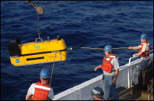
In 2006, the NOAA Diamond Shoals Data Buoy was moved into the boundaries ofMonitor National Marine Sanctuary. This buoy collects real-time data on water temperature, surface and subsurface currents, and wind speed at the site. The buoy will allow for future tracking of these conditions within the sanctuary.
1. Are specific or multiple stressors, including changing oceanographic and atmospheric conditions, affecting water quality?
The water quality in the Monitor sanctuary is considered to be good; conditions do not appear to have the potential to negatively affect living resources or habitat quality. The trend is not changing. However, it is important to note the distinction that although water quality can be considered good in relation to living marine resources, such conditions can be considered poor with regard to the preservation of wreck sites.
The strong currents, high water temperatures and high-salinity water that are found off the coast of Cape Hatteras, N.C., has the potential to accelerate the deterioration rate of the USS Monitor. The strong currents bring dissolved oxygen that corrodes the metal on the wreck. The data buoy therefore provides critical information on the changes in these parameters over time. Trends seem to indicate a relationship between corrosion and salinity measurements; however, the sanctuary does not currently have long-term data comparing these parameters. Water current modeling will be an area of heavy focus in research in coming years (NURC pers. comm.).
In 2007, the Monitor sanctuary, working with the National Data Buoy Center, added an acoustic doppler current profiler to the Diamond Shoals data buoy. This instrument will allow the public and scientists to better understand the subsurface environment over the wreck. Additionally, staff at the Monitor sanctuary is looking to collect water quality data by installing pH and water chemistry instruments to the buoy at the site. Such meters would allow for a better understanding of the pH levels at the site and the effects that acidification may be having on the wreck and the ecosystem.
2. What is the eutrophic condition of sanctuary waters and how is it changing?
The Monitor is located in an open ocean environment that is well mixed and too deep for eutrophication to be a management concern. Therefore the situation is considered to be good and not changing; conditions do not appear to have the potential to negatively affect living resources or habitat quality at the site.
3. Do sanctuary waters pose risks to human health?
There is no evidence suggesting that sanctuary waters pose any risks to human health; in this respect, water quality is considered to be good, and conditions do not appear to have the potential to negatively affect human health. The condition appears to be stable.
4. What are the levels of human activities that may influence water quality and how are they changing?
Although there is visitation to the site, typically by charter fishing boats, there are relatively few hazardous discharges, minimal debris at present, or other known impacts on the water quality at the sanctuary. Thus, few human activities occur that are likely to negatively affect water quality. The trend is not changing.
Water Status and Trends
Status: Good Good/Fair Fair Fair/Poor Poor Undet.
Trends:
▲ Conditions appear to be improving. Since designation in 1975, Monitor National Marine Sanctuary has focused primarily on documenting, preserving and managing the remains of the Monitor. Because of this focus, studies have been conducted regarding the habitats and living resources of the sanctuary. In 1982, scientists from Pennsylvania State University conducted a study of organisms encrusting the hull of the Monitor shipwreck. They examined the wreck’s concretionary crust for growth and diversity of bryozoans — tiny polyps that live in colonies attached to hard objects on the seafloor. The study identified 11 species of encrusting cheilostome bryozoans, serpulid worms, corals and pelecypods. The species found are typical of hard bottoms at mid-depths on the Atlantic shelf. (Cuffey 1982)
In 1990, the NOAA Fisheries Lab in Beaufort, North Carolina conducted a study of the living resources in the Monitor sanctuary. Utilizing visual observations on two dives and video tape from four dives the NOAA researchers were able to assess species diversity in the sanctuary. Twenty-five species of fish were observed. The most abundant species appeared to be red barbier (Hemanthias vivanus), while the predominant predator was greater amberjack (Seriola dumerili). Other common species included scad, black seabass, bank seabass, slippery dick and vermilion snapper. The study also identified encrusting organisms and motile invertebrates from one grab sample and recorded video footage. The most abundant coral growing on the wreck of the Monitor was the ivory bush coral (Oculina arbuscula). Approximately 40 species of sponges were identified. (Dixon 1990) A study being conducted in the vicinity of the Monitor sanctuary is examining zooplankton and ichthyoplankton dynamics, as well as other aspects of the ecosystem. The National Marine Fisheries Service Northeast Fisheries Science Center (NEFSC) initiative started in the1960s and led to the Marine Resources Monitoring Assessment and Prediction Program in 1987, and later to the Ecosystem Monitoring Program, which started in the mid-1990s. Most of the NEFSC plankton sampling has occurred north of Cape Hatteras, thus, samples are sparse in the vicinity of the Monitor sanctuary. The top 25 taxa accounted for 78 percent of the total zooplankton collected. The most abundant was the copepod Centropages typicus, followed by the cladoceran Penilia avirostris and unclassified ostracods. Other abundant taxa included appendicularia, chaetognaths and several other copepods. Other studies underway near the Monitor sanctuary include benthic surveys organized by researchers from NOAA and the University of North Carolina at Wilmington and University of North Carolina Chapel Hill. 5. What is the abundance and distribution of major habitat types and how is it changing?
Habitats in the Monitor sanctuary are in near-pristine condition and are unlikely to preclude full community development at the site. Further, conditions appear at present to be improving, following recent changes in habitat availability at the site. TheUSS Monitor, like many other shipwrecks in the Graveyard of the Atlantic area, provides a habitat structure to the otherwise sandy bottom that is found off the coast of Cape Hatteras. The Monitor and other wrecks create new habitat by acting as an artificial reef that supports both transitory organisms, such as sea turtles and fishes, and local communities such as encrusting organisms and motile invertebrates.
It has been observed that when a piece of the Monitor is removed or disturbed there is succession of life that returns to the site over time. So while the Monitordiversifies the area’s habitat types, ecological succession results in a diversification of biological assemblages. 6. What is the condition of biologically structured habitats and how is it changing?
Although there are no biologically structured habitats at the Monitor sanctuary, there is a thriving assemblage of encrusting faunal organisms on the wreck. Such organisms can reduce the corrosion rates of the site. However, data has not been collected to determine the condition of such communities and how they are changing. Therefore, the status and trends of biologically structured habitats are currently undetermined. To date, the Monitor sanctuary staff has not conducted research on natural resources within its boundaries. The need for additional studies will likely be identified through the sanctuary’s management plan review process, and a long-term monitoring and data collection program will be established.
An exact census of the biodiversity within Monitor National Marine Sanctuary has not been conducted. The sanctuary was originally established based on cultural resources and not on the natural resources found within its boundaries. To date, no rare or endangered species have been reported living on the wreck or within the sanctuary’s borders. Loggerhead sea turtles (Caretta caretta) are often sighted within sanctuary borders swimming or drifting along in the Gulf Stream. As an artificial habitat, the wreck saw significant changes during the recovery operations from 1998-2002. Areas at the stern of the wreck were altered or removed to gain access to components of the Monitor that were targeted for recovery. The forward areas of the wreck have remained mostly untouched since the Monitor originally sank in December 1862 and a variety of sponges and soft corals thrive on this part of the wreck. The hard structure provided by the Monitor’s hulk is completely covered with a thick marine calcareous growth that provides an excellent surface for sponge and coral growth. Fishes and invertebrates also abound in this area, using shipwreck structure for feeding grounds or shelter. 7. What are the contaminant concentrations in sanctuary habitats and how are they changing? Contaminants in sediments at the Monitor sanctuary do not appear to be at levels that have the potential to negatively affect living resources or water quality. The trend is not changing. The low levels of contaminant concentrations are most likely attributable to the remote location of the wreck and the strong currents of the Gulf Stream. The strong currents cause a constant resuspension of sediments, thus flushing any contaminants that might otherwise accumulate.
8. What are the levels of human activities that may influence habitat quality and how are they changing? There is relatively little human activity that influences the habitat quality at theMonitor sanctuary. There is limited visitation to the site, and those that do visit are typically on chartered fishing boats, but there are relatively few hazardous discharges, little debris or other impacts on the habitat quality. Thus, while some potentially harmful activities exist, but they do not appear to have had a negative effect on habitat quality, and the status does not appear to be changing. Habitat Status and Trends Status: Good Good/Fair Fair Fair/Poor Poor Undet. Trends:
▲ Conditions appear to be improving. 9. What is the status of biodiversity and how is it changing?
The living resource assemblage at the Monitor sanctuary is currently poorly known due to the lack of a biological monitoring program; therefore, the status and trend of biodiversity are undetermined. Anecdotal evidence shows that the sanctuary experiences seasonal migrations of cetaceans, sea turtles, and fishes, including sharks and manta rays. Tropical and temperate fish, such as black sea bass, snapper and grouper, represent the most abundant species that seasonally visit the sanctuary’s waters. Encrusting organisms and motile invertebrates are also present in the sanctuary. Invertebrates include crabs, brittle stars, sea urchins, snapping shrimp and spiny lobsters. Sea anemones, hydroids, barnacles, tube worms, mussels, oysters and at least 40 species of sponges have been identified in the sanctuary.
10. What is the status of environmentally sustainable fishing and how is it changing?
Currently, the removal of fish is not an issue that affects the Monitor sanctuary. The Monitor sanctuary lies within the jurisdiction of the South Atlantic Fishery Management Council, which manages fishery species of interest at the Monitor site. The Council is responsible for the conservation and management of fish stocks within the federal 200-mile limit off the coasts of North Carolina, South Carolina, Georgia and east Florida to Key West. Commercial fishing, including live boating by charter boats, is allowed within the sanctuary; however, other commercial fishing activities including anchoring, bottom trawling, dredging, stopping or drifting without power at any time is prohibited due to the potential threat to the fragileMonitor shipwreck.
11. What is the status of non-indigenous species and how is it changing?
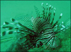
At least one non-indigenous species (red lionfish, Pterois volitans) exists in the Monitor sanctuary, likely affecting to some extent the development and function of the associated biotic assemblage at the site. But given current abundance, they are unlikely to cause substantial or persistent degradation of ecosystem integrity. The condition, however, appears to be getting worse.
Marine biologists at NOAA’s Center for Coastal Fisheries and Habitat Research in Beaufort, N.C., are currently conducting research on the red lionfish. It is the first marine invasive fish suspected to have established itself in the sanctuary (Private Research Permit MNMS-01-2007).
During a private research dive to the site in 2007, a large adult red lionfish was observed on the wreck. Adult red lionfish are about 17 inches long and have been observed and caught from Florida to Cape Hatteras, usually on wrecks and natural hardbottom at depths of 85 to 300 feet. The red lionfish is a voracious predator and could threaten local ecosystems. Species such as snapper and grouper may be at risk as red lionfish feed on the same food sources and compete for the same habitat. Also, red lionfish pose a danger to divers and fisherman — spines of the fish may cause an extremely painful sting, resulting in swelling and sometimes paralysis. In the future, the sanctuary plans to expand its biological monitoring program to track red lionfish status and trends, as well as monitor other potential non-indigenous species.
12. What is the status of key species and how is it changing?
A comprehensive biological inventory and assessment of the Monitor would need to be conducted to identify key species at the site. No species that inhabit the Monitorare currently identified as key species. Nearly all monitoring and research is devoted to archaeological resources. Nevertheless, it might be useful to identify and track the status of particular fouling and reef associated species in order to track the progress of artificial reef development. This is partly because the level of development of the fouling community can affect the rate of deterioration of the structure of the Monitor, and because the nature of the fouling assemblage and associated fish communities, affects the level of visitation by fishers and others that could affect the quality of the Monitor.
13. What is the condition or health of key species and how is it changing?
No species that inhabit the Monitor are currently identified as key species, but for reasons stated above, it would be helpful to do so.
14. What are the levels of human activities that may influence living resource quality and how are they changing?
Fishing activities can affect artificial reef habitat quality but it does not appear that they have had a negative effect on living resource quality at the Monitor. The condition is currently stable. Nevertheless, trawling and anchoring can affect the biological community at the sanctuary by removing or damaging portions of the wreck, resulting in the removal of hiding locations for fish and invertebrates. These activities are prohibited by sanctuary regulations.
Living Resources and Trends Status: Good Good/Fair Fair Fair/Poor Poor Undet. Trends:
▲ Conditions appear to be improving.
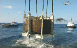
Since the establishment of Monitor National Marine Sanctuary in 1975, dozens of research and recovery expeditions have been conducted within the sanctuary. These expeditions have resulted in detailed documentation of the wreck and surrounding area and the recovery of the anchor, steam engine, propeller and propeller shaft, rotating gun turret, two XI-inch guns and carriages, and over 1,000 smaller artifacts from the wreck site.
To date, research expeditions have recovered over 1,200 artifacts from the wreck. Many of these artifacts have already undergone conservation and are currently on exhibit at The Mariners’ Museum in Newport News, Virginia. Many other artifacts, including the gun turret, guns and engine are still undergoing conservation. The wreck of the Monitor lies upside down on a relatively flat, sandy bottom in 230 feet of water. The hull lies in an east-west orientation with the bow pointing at approximately 273 degrees. The port side of the inverted hull is raised above the seabed, as it was originally supported by the turret following sinking. Prior to turret recovery in 2002, a series of grout bags were installed underneath the armor belt to provide structural support. The port side’s maximum relief is 9.5 feet at the stern, angling down towards the seabed at the bow. Height above the seabed at the bow is 6.5 feet. Maximum elevation in the wreck is 12.5 feet at the port boiler. The starboard side of the wreck is completely buried in the sand, except for short segments of the armor belt at the bow and stern. Hull frames also protrude from the sand on the starboard side. All of the lower hull plating forward of the midships bulkhead degraded and collapsed before the Monitor was discovered in 1973. The last three sections of intact hull plating and a section of bottom plating over the engine and fire room were removed by NOAA and the U.S. Navy in 2001 to gain access to the Monitor’ssteam engine. Bottom plating covering the boilers and galley area was dislodged from the wreck in 2003. This damage is attributed to the eye of Hurricane Isabel passing within three-quarters of a mile of the wreck in September 2003. The damage caused by Isabel also destroyed the remaining side framing along the port and starboard sides of the boilers and completely collapsed the remaining portions of the midships bulkhead. Accelerated deterioration of the stern was first documented in 1990. By 1995, approximately six feet of the port armor belt had deteriorated in this area. Approximately 24 feet of the stern has disintegrated since the vessel sank in 1862. This accelerated deterioration of the armor belt was combined with deterioration of the ship’s armored decking. Several deck plates were observed hanging down from the wood planking to which they were originally spiked. Others had completely dropped off and were buried in the sand. All of these observations prompted NOAA to release a revised management plan in 1998 that led to the shoring-up of the hull in 2000 and the recovery of the Monitor’s steam engine in 2001 and rotating gun turret in 2002. A 45-foot section of the port armor belt was removed by NOAA and the Navy in 2002 to gain access to the rotating gun turret. This segment was cut free and lifted off the wreck and placed 50 feet to the north of its original location. During the summer of 2006, NOAA worked with a private research organization to continue documenting the damage from the 2003 hurricane. Deterioration at the stern is continuing. (Monitor National Marine Sanctuary 2003) 15. What is the integrity of known maritime archaeological resources and how is it changing? Strong currents, high-temperature, and high-salinity water in Monitor National Marine Sanctuary have a significant effect on the sanctuary’s living and non-living resources. Since its discovery, the wreck has suffered significant natural deterioration in almost every portion of its hull, with the most extensive damage occurring in the stern. Unauthorized human activities (including an illegal anchoring incident in 1991) also affected the deterioration rate. In response to accelerated deterioration documented in the early 1990s, NOAA issued a new management plan in 1998 for the Monitor sanctuary that outlined goals for stabilizing raised portions of the ship’s hull and recovering some of the ships iconic components. In 1998, NOAA partnered with the U.S. Navy and recovered the Monitor’s cast iron propeller and an 11-foot section of the propeller shaft. The Monitor’s unique steam engine was recovered in 2001, and the rotating gun turret and cannons were recovered in 2002. All of these sanctioned activities had a significant impact on the wreck. Areas of concretion covering portions of the hull and hull plating had to be cleared away. Removal of this material reintroduces fresh oxygen to areas of the hulk where corrosion had been slowed by the marine calcareous growth. Recovery operations also exposed areas of wood components of the ships structure that were previously buried. Exposed areas of wood now show signs of being attacked by shipworms (Teredo navalis) which are accelerating the deterioration rate. This form of collateral damage was anticipated and expected by NOAA owing to the scope of work being conducted on the wreck. Thus, the Monitor does exhibit indications of disturbance, but there appears to have been little or no reduction in historical, scientific, or educational value. There are currently negligible unexpected changes occurring, and the condition is therefore considered stable. 16. Do known maritime archaeological resources pose an environmental hazard and is this threat changing? The Monitor does not pose an environmental threat to its environment because it does not contain potential contaminants or hazardous cargo. The threat is not changing. 17. What are the levels of human activities that may influence maritime archaeological resource quality and how are they changing? Selected activities have resulted in measurable impacts to the archaeologicalresources of the Monitor sanctuary, but evidence suggests effects are localized, not widespread. Furthermore, perhaps because there is currently limited visitation to the site, typically by charter fishing boats, there are relatively few hazardous discharges, debris or other impacts to the Monitor. The level of these threats does not appear to be changing. However, some evidence of marine debris and anchoring impacts has been observed at the site. The first evidence of anchoring was documented in the 1990s and incidents have continued. However, the frequency of anchoring does not seem to be changing. In 1991, a private fishing vessel illegally anchored in the sanctuary and likely resulted in the skeg and propeller shaft dislocation and removal from the lower hull, exposing the aft end of the engine room. Within the past few years, debris has been observed on the wreck. Most debris, like cans and food, is the result of charter fishing vessels visiting the site. One threat that marine debris poses to the site is that it could be recovered and mistakenly treated as part of the Monitor’sartifacts. There have also been observations of commercial fishing gear, monofilament, trawling nets and long lines tangled on the site. Looting is a potential pressure that exists; however, because of the depth and remote location of the site, it is unlikely to occur. Likewise, it is believed that human impacts at the site are likely not to change within the next five years. Therefore, the level of human activities that may influence maritime archaeological resource quality is considered to be “fair” and not changing. Non-divers interested in learning about the Monitor can visit one of the many partner museums and aquariums with exhibits that tell the story of the historic vessel and NOAA’s efforts to preserve it. The USS Monitor Center at The Mariners’ Museum in Newport News, Va., opened in March 2007 and is the primary visitor center for the sanctuary. Over 125,000 people visit this museum each year. With visitation of approximately 250,000 per year, Nauticus in Norfolk, Va. is home to an interactive exhibit on the Clelia, a submersible that visited the Monitor wreck site on several occasions. The North Carolina Aquarium on Roanoke Island (400,000 visitors/year) and the Graveyard of the Atlantic Museum (60,000 visitors/year) in Hatteras, N.C., are great places to see the marine life that call the Monitor home and learn more about the important history of the vessel. Increased visibility for the sanctuary via these and other exhibits provide public outreach and educational value that help promote preservation of the shipwreck. Maritime Archaeological Resources and Trends Status: Good Good/Fair Fair Fair/Poor Poor Undet. Trends:
▲ Conditions appear to be improving.
- Conditions do not appear to be changing.
▼ Conditions appear to be declining.
? Undeterminted trend.
N/A Question not applicable.
#
Status
Rating
Basis For Judgement
Description of Findings
1.
Stressors

Water current modeing and its effects on dissolved oxygen. No human impacts.
2.
Eutrophic Condition
The Monitor is located in water that is deep and well-mixed, therefore eutrophication is noa a management concern
3.
Human Health
No evidence that there is any risk posed.
4.
Human Activities
Relatively few hazardous discharges, debris or other impacts.
Habitat and Living Resouces
- Conditions do not appear to be changing.
▼ Conditions appear to be declining.
? Undeterminted trend.
N/A Question not applicable.
#
Status
Rating
Basis For Judgement
5.
Abundance/ Distribution
![]()
Monitor atracts biological assemblages as an artificial reef.
6.
Structure
No specific studies conducted; encrusting faunal organisms reduce the rate of corrosion.
7.
Contaminants
Lack of sources and constant resuspension of sediments flushing any contaminants that may accumulate.
8.
Human Activities
Limited human activity due to remote location and restrictions.
- Conditions do not appear to be changing.
▼ Conditions appear to be declining.
? Undeterminted trend.
N/A Question not applicable.
#
Status
Rating
Basis For Judgement
9.
Biodiversity
Lack of biological monitoring program.
10.
Extracted Species
N/A
11.
Non-indigenous Species
One Red Lionfish identified in sanctuary in summer 2007.
12.
Key Species
No key species have been identified; no specific studies conducted.
13.
Health of Key Species
No key species have been identified; no specific studies conducted.
14.
Human Activities
Evidence that fishing activities affect habitat quality and thus living resources.
Maritime Archaeological Resources
- Conditions do not appear to be changing.
▼ Conditions appear to be declining.
? Undeterminted trend.
N/A Question not applicable.
#
Status
Rating
Basis For Judgement
15.
Integrity
Combination of natural deterioration and site alteration due to archaeology activities from 1996-2002
16.
Threat to Environment
Lack of hazardous cargo
17.
Human Activities
Prior evidence of marine debris and anchoring. Site is susceptible to future incidents of fishing strkes and debris accumulation.