Terrestrial Input to Coastal Big Sur
Conservation Issue
The ability of managers to adequately protect Monterey Bay National Marine Sanctuary (MBNMS) nearshore habitats in the Big Sur region from terrestrial inputs (e.g., landslides, debris flows) is hindered by incomplete knowledge of the oceanography, biology, and geology along the coastline of Big Sur.
Description
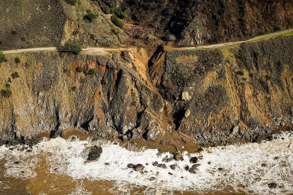
Adjacent to MBNMS, the Big Sur coastline along the central coast of California is a spectacular meeting of land and ocean characterized by high cliffs, rugged canyons, and crashing surf. Recent terrestrial input of sediment and vegetation, both from landslides and debris flows, has been catastrophic to intertidal populations, including endangered black abalone (Haliotis cracherodii). Highway 1 cuts through the geologically diverse Big Sur coastline and has a long history of such events that have both landed on the highway and undermined the roadbed. Prior to the designation of the sanctuary, maintenance practices of the California Department of Transportation (CalTrans) along this stretch of Highway 1 often involved moving terrestrial material shoreward, sometimes into the intertidal zone. Maintenance and catastrophic road repair activities can deviate considerably from the natural processes that disperse sediment into coastal systems. Terrestrial, unconsolidated material (UM) affects marine habitats and biological communities by direct burial, scour, and turbidity. MBNMS regulations prohibit the discharge of material within sanctuary boundaries and prohibit the disposal of material outside the sanctuary boundaries that subsequently enters the sanctuary and harms resources. Following a severe landslide season in 1998, CalTrans led the development of the Coast Highway Management Plan (CHMP) to create a decision framework to guide the deposition of UM. The CHMP was an excellent start, but MBNMS still lacks a complete survey of marine resources along geologically active areas, burn scars, and sites where CalTrans may seek to deposit rock and soil debris onto or above the shoreline, which in turn may move into the ocean. Collaborative management and interagency partnerships can be better informed through the integration of biological, geological, and oceanographic knowledge about the habitat areas surrounding these vulnerable sites.
Data and Analysis Needs
- Locations where slides and debris flows of different magnitudes have been most concentrated in the past
- Areas along the Big Sur coastline that are more or less susceptible to landslides and debris flows in the next century
- Biology and geology associated with historic and future slides and debris flows, and the major habitat types in associated intertidal and subtidal areas
- Nearshore patterns of water movement, sand movement/littoral cells, and exposure to wave energy in potentially affected areas
- Locations where historic accumulations of UM from slides and debris flows have dispersed to in the nearshore environment, and where such UM might be transported in the future
- Ecological impacts of UM on intertidal and shallow subtidal communities
- Vulnerability of watersheds that have been burned and are in the path of atmospheric river events, which in turn can lead to debris flows
Potential Products
- Visualization of historic slide hot spots and debris flows by magnitude of UM deposited over time
- Increased ability to predict the properties of different types of geology in the Big Sur region Improved predictions of offshore sediment transport along the Big Sur coast, including estimating natural inflows and outputs and physical characteristics of deposited UM
- Decision-making protocols that minimize ecological impacts of road maintenance
- Integration of new data products with GIS data layers from other agencies
- Enhanced avoidance of UM deposition at critical, sensitive habitats and identification of areas with lower resource value that may be suitable for ocean deposition of rock and soil by CalTrans
- Predicted impacts of UM to downcoast or upcoast ecological communities where UM may be transported by currents
Suggested Scientific Approach and Actions
- Develop updated maps showing recent and historic slides, debris flows, and fire scars, and CalTrans management activities, including past deposition sites and volume of UM
- Develop updated maps showing predicted slide and debris flow areas, with high, medium, and low risk rankings
- Conduct research, characterization, and monitoring of the intertidal and nearshore subtidal resources and seabird and marine mammal aggregation areas below the highway
- Develop maps of intertidal and subtidal geology types and associated biota
- Conduct shallow benthic mapping of substrate type and topography/bathymetry at high resolution
- Using the shoreline sensitivity assessment conducted by the Partnership for the Interdisciplinary Studies of Coastal Oceans (PISCO) and MBNMS’ Big Sur Nearshore Characterization project data, develop a map of major intertidal and subtidal habitat types
- Create high-resolution visualizations of nearshore patterns of water movement, sand movement/littoral cells, and wave energy
- Create a map that links landslide and debris flow photos and videos to specific locations
Key Partners
U.S. Geological Survey, California Geological Survey, Bureau of Ocean Energy Management, Caltrans, U.S. Fish and Wildlife Service, U.S. Forest Service, California State Parks, California State Water Resources Control Board, California Coastal Commission, Bureau of Land Management’s California Coastal National Monument, California State University Monterey Bay, University of California Santa Cruz
For more information about this assessment, contact Steve.Lonhart@noaa.gov.