State of Sanctuary Resources: Seamount Environment
Monterey Bay National Marine Sanctuary
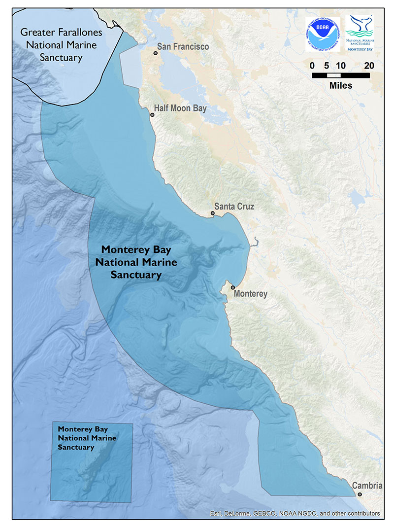
After the 2009 Condition Report was drafted, NOAA expanded Monterey Bay National Marine Sanctuary to include the Davidson Seamount. Davidson Seamount is the first seamount to be protected within a United States national marine sanctuary. The following information provides the first summary of conditions and trends for four resource areas in the seamount environment: (1.) water, (2.) habitat, (3.) living resources and (4.) maritime archaeological resources.
The Davidson Seamount is an undersea mountain habitat off the coast of central California, 75 miles (121 kilometers) due west of San Simeon. At 26 miles (42 kilometers) long and 8 miles (13 kilometers) wide, it is one of the largest known seamounts in U.S. waters. From base to crest, the seamount is 7,480 feet (2,280 meters) tall, yet its summit is still 4,101 feet (1,250 meters) below the sea surface.
In 1938, Davidson Seamount was the first to be characterized as a "seamount" by the United States Board on Geographic Names. Furthermore, it was named in honor of the United States Coast and Geodetic Survey scientist George Davidson, a leader in charting the waters of the West Coast.
New technology has only recently allowed scientists to bring back dramatic high resolution images from the deep-sea, offering researchers and the public an opportunity to witness the never before seen glimpses of rare marine species living in this largely cold, dark and mysterious habitat. The proximity of education and research institutions in the Monterey Bay region facilitate interdisciplinary collaborations that enhance research and education about this spectacular area.
The Office of National Marine Sanctuaries determined the Davidson Seamount requires protection from the take of or other injury to benthic organisms or those organisms living near the seafloor because of the seamount's special ecological and fragile qualities and potential future threats that could adversely affect these qualities. As part of the 2008 Management Plan for MBNMS, a boundary change included the undersea mountain as Davidson Seamount Management Zone (DSMZ) (Figure 56). The boundary change added a 775 square mile (2,007 square kilometers) area to MBNMS, increasing MBNMS’s area to 6,094 square miles (15,783 square kilometers).
Seamount Environment: Water Quality
Though relatively close to shore (70 nautical miles to the southwest of Monterey) and one of the largest known seamounts in U.S. waters, Davidson Seamount appears to be relatively pristine, based on observations of biological communities during sea surface and submersible explorations (2002-2010). No water quality monitoring occurs within Davidson Seamount Management Zone; however, an abundance of marine mammals and seabirds at the sea surface, and large, diverse, abundant cold-water corals and sponges on the seamount may indicate that the water quality is good and that there are few, if any, risks to human health.
1. Are specific or multiple stressors, including changing oceanographic and atmospheric conditions, affecting water quality?
No information specific to DSMZ is available on specific stressors affecting water quality. For this reason, the rating for this question is “undetermined.” A trend is “undetermined” due to a paucity of data. However, see the Offshore Environment section of this report for related information.
2. What is the eutrophic condition of sanctuary waters and how is it changing?
No information specific to DSMZ is available on eutrophic conditions. For this reason, the rating for this question is “undetermined.” A trend is “undetermined” due to a paucity of data. However, see the Offshore Environment section of this report for related information.
3. Do sanctuary waters pose risks to human health?
No information specific to DSMZ is available on risks to human health. For this reason, the rating for this question is “undetermined.” A trend is “undetermined” due to a paucity of data. However, see the Offshore Environment section of this report for related information.
4. What are the levels of human activities that may influence water quality and how are they changing?
Threats exist to water quality in Davidson Seamount Management Zone, such as vessel traffic, marine debris/dumping and global climate change (see Table 2 for a full list of potential threats and their ratings). At present, vessel traffic, sea temperature rise and ocean acidification appear to be the most severe threats to DSMZ (MBNMS 2012). Recently, the levels of large vessel traffic in and around DSMZ were quantified; however, the activity level of other threats has not been quantified, and it is unknown if the cumulative activity level is changing. Concurrently, these activities’ potential impacts to water quality and other resources in DSMZ have not been studied. Therefore, this question is rated “good/fair” with an “undetermined” trend.
Table 2 A recent threats assessment for Davidson Seamount Management Zone (DSMZ) describes the known existing and potential threats to DSMZ. Threat levels of low, medium and high were assigned to the various threats. To be assigned a threat level of low there must be (1.) existing regulations to protect against that threat, or (2.) it must be accepted that the activity associated with the threat is currently impossible or highly unlikely to occur. To be assigned a threat level of medium, there must be (1.) a possibility that the threat activity will occur (either legally through a permitting process or otherwise) despite existing regulations to protect against that threat, or (2.) there are no current protections against the threat, but also the threat activity is not known to occur. To be assigned a threat level of high, there must be no regulatory protections in place against the threat and the threat activity is known occur or is likely to occur. At present, vessel traffic, sea temperature rise and ocean acidification appear to be the most severe threats to DSMZ.
Credit: MBNMS 2012
|
Threat Level |
||
Threat |
Low |
Medium |
High |
Vessel Traffic |
|
|
|
Submerged Vessels |
|
|
|
Military Activity |
|
|
|
Bio-Prospecting |
|
|
|
Cumulative Research Collection |
|
|
|
Commercial Harvesting: |
|
|
|
Commercial Harvesting: |
|
|
|
Commercial Harvesting: |
|
|
|
Oil and Gas Exploitation |
|
|
|
Deep-sea Mining |
|
|
|
Marine Debris/Dumping |
|
|
|
Underwater Cables |
|
|
|
Water Quality |
|
|
|
Sea Temperature Rise |
|
|
|
Ocean Acidification |
|
|
|
Threats to water quality from vessel traffic include oil or chemical spills and discharges, loss of cargo and other marine debris, ship-based pollution (i.e., residues from tank cleaning), exchange of ballast water and noise pollution (MBNMS 2012). When compared to coastal waters, DSMZ’s offshore location reduces the risk of impacts from accidents and spills caused by collisions and groundings. However, transiting vessels, in particular those carrying crude oil, bunker fuel or other hazardous materials, have the potential to impact water quality in DSMZ (MBNMS 2012).
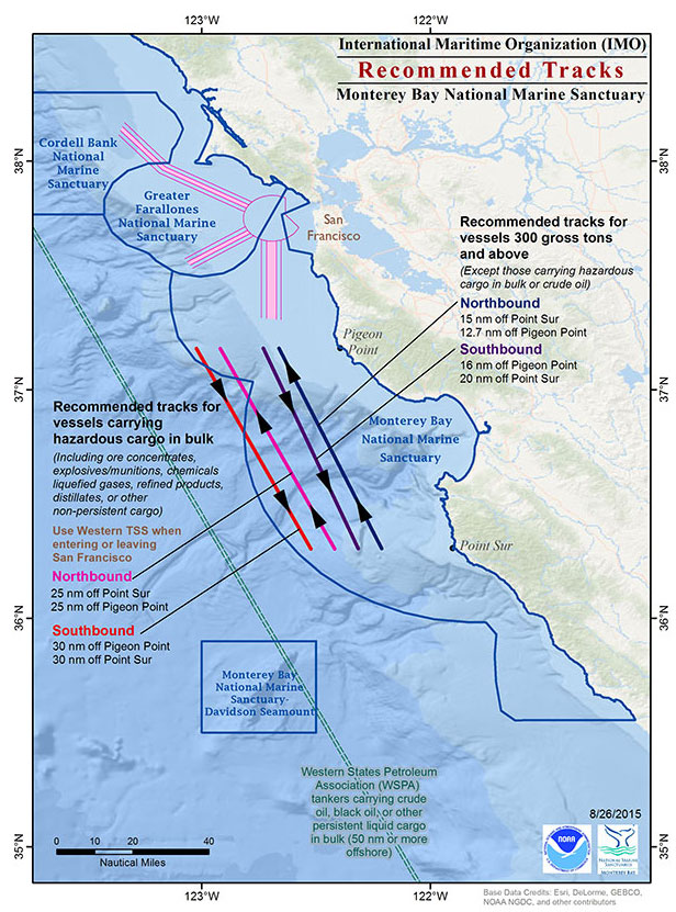
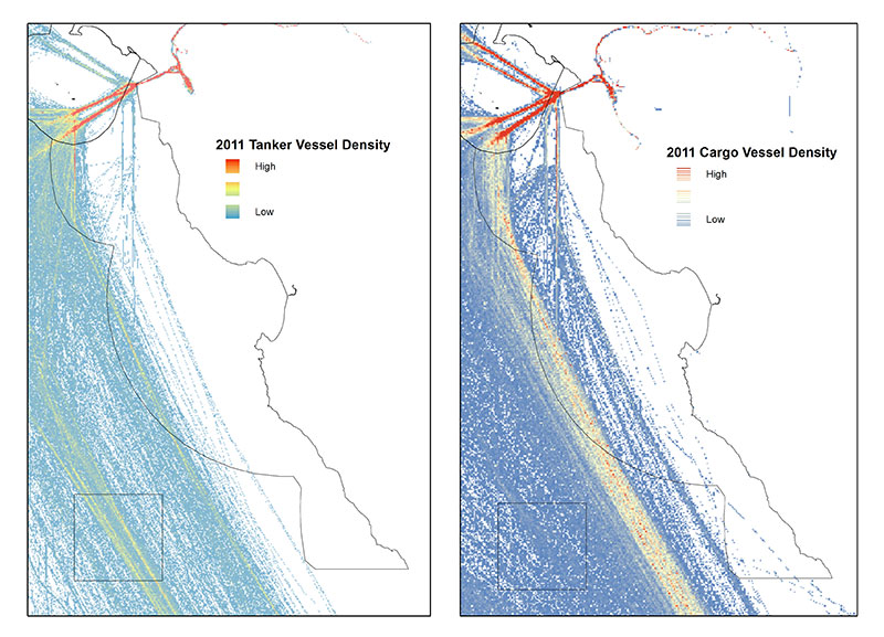
DSMZ’s the northeast corner is bisected by the Western States Petroleum Association (WSPA) recommended shipping tracks for tankers that carry crude oil, black oil or other persistent liquid cargo in bulk (Figure 57). Miller (2011) found that the average number of vessel transits through DSMZ in 2010 was 159 per month. An analysis of vessel traffic (2009-2012) indicates that a great majority of the large vessels that transit in or near MBNMS comply with the WSPA and International Maritime Organization (IMO) recommended tracks shown in Figure 57 (De Beukelaer et al. 2014). For example, Automatic Identification Systems (AIS) data from 2011 show that the majority of tankers cross over DSMZ near the WSPA recommended track and the majority of cargo vessels transited between DSMZ and MBNMS on MBNMS’s western boundary via the IMO recommended tracks (Figure 58).
It would be useful to further explore the AIS data for trends in the number of vessels that transit through DSMZ on a monthly or annual basis. Data on the contents of each vessel and the levels of discharge from these vessels would improve understanding of the threat posed by tanker traffic and how this has changed over time. However, based on known impacts of previous spills elsewhere and known levels of vessel traffic, these pressures are considered to have the potential to degrade water quality, and may preclude full function of living resource assemblages and habitats, should they occur.
Seamount Environment Water Quality Status and Trends
Status: Good Good/Fair Fair Fair/Poor Poor Undet.
Trends:
▲ Conditions appear to be improving.
- Conditions do not appear to be changing.
▼ Conditions appear to be declining.
? Undeterminted trend.
N/A Question not applicable.
| # | Issue | Rating | Confidence | Basis For Judgement | Description of Findings |
|---|---|---|---|---|---|
| 1. | Stressors | Status: N/A Trend: N/A |
No information available specific to DSMZ; however, see the open ocean section of this report. | Not enough information to make a determination. | |
| 2. | Eutrophic Condition | Status: N/A Trend: N/A |
No information available specific to DSMZ. | Not enough information to make a determination. | |
| 3. | Human Health | Status: N/A Trend: N/A |
No information available specific to DSMZ. | Not enough information to make a determination. | |
| 4. | Human Activities | Status: Medium Trend: Medium |
Large vessel, particularly tankers, transiting through DSMZ poses a threat to water quality, but no known impacts from this activity. More information needed on levels and trends of other potential threats. | Some potentially harmful activities exist, but they do not appear to have had a negative effect on water quality. |
Seamount Environment: Habitat
5. What is the abundance and distribution of major habitat types and how is it changing?
The abundance and distribution of major habitat types in the sanctuary’s seamount environment is rated "good." Habitat quality is considered to be in pristine or near-pristine condition due to limited past and current levels of human activities that could influence the distribution, abundance, and quality of benthic habitats. The trend is rated "not changing" due to the seamount’s remote nature, and current regulations by Monterey Bay National Marine Sanctuary and NOAA Fisheries that prohibit alteration of the seafloor and use of bottom-contact fishing gear, respectively.
The geological structure and origin of five central California seamounts (Davidson, Guide, Pioneer, Gumdrop and Rodriguez) have only recently been described as an atypical type of oceanic volcanism, having northeast-trending ridges that reflect the ridge-parallel structure of the underlying crust (Davis et al. 2002). The Davidson Seamount consists of about six subparallel linear volcanic ridges separated by narrow valleys that contain sediment. These ridges are aligned parallel to magnetic anomalies in the underlying ocean crust. The seamount is 12.2 ± 0.4 million years old and formed about eight million years after the underlying mid-ocean ridge was abandoned. Unlike most intra-plate ocean island volcanoes, the seamounts are built on top of spreading center segments that were abandoned at the continental margin when the tectonic regime changed from subduction to a transform margin (Davis et al. 2007). Davidson Seamount is the largest of the five seamounts; it is ~42 kilometers long, ~13 kilometers wide and rises ~2,280 meters from the ocean floor to a water depth of ~1,250 meters (Davis et al. 2002). Its volume above the seafloor is~320 cubic kilometers (Davis et al. 2002).
DSMZ’s benthic habitat (775 square miles) can be partitioned into three habitat types: (1.) summit, (2.) flanks (or slope) and (3.) base (McClain et al. 2010). In addition, the water column habitat (1,595 cubic miles) can be partitioned into three habitat types: (1.) sea surface, (2.) mid-water and (3.) bentho-pelagic. Structure-forming invertebrates, such as the many species of corals and sponges at Davidson Seamount, hold an important ecological role to create habitat structure, and are vulnerable to disturbance from human activities (MBNMS 2012).
Due to its deep, offshore location, few institutions have yet to conduct research activities at the seamount (i.e., MBNMS, MBARI, USGS). Most of the research involves video surveys; however, rocks and biogenic habitat have been collected, as well as the occasional placement of anchored markers for repeated measurements (e.g., coral age and growth studies). Collectively, these activities have a small footprint and do not threaten the abundance and distribution of habitat types.
During a 2006 ROV dive survey, researchers discovered a telecommunications cable that runs along the side of the seamount (MBNMS 2012). The history and current status of the cable is unknown. Submarine cables could become destructive to biogenic habitats (e.g., corals and sponges) if they become mobile.
Recent regulatory actions were taken to protect the seafloor on and around Davidson Seamount. In June 2006, the NMFS prohibited fishing with bottom contact gear (or any other gear) below 3,000 feet in the Davidson Seamount Essential Fish Habitat (EFH) Conservation Area (NMFS, DOC 2006). In November 2008, Monterey Bay National Marine Sanctuary expanded to include Davidson Seamount Management Zone. Standard sanctuary regulations apply (including the seabed alteration prohibition), and the “take”61 of biological or non-biological resources below 3,000 feet is prohibited (DOC 2008). The Davidson Seamount EFH Conservation Area and DSMZ share the same boundaries and were created to address potential threats to the seamount and natural resources (MBNMS 2012). The seamount itself is too deep for most fish trawling methods, where fish density is very low, and the species seen to date are not commercially desirable.
6. What is the condition of biologically-structured habitats and how is it changing?
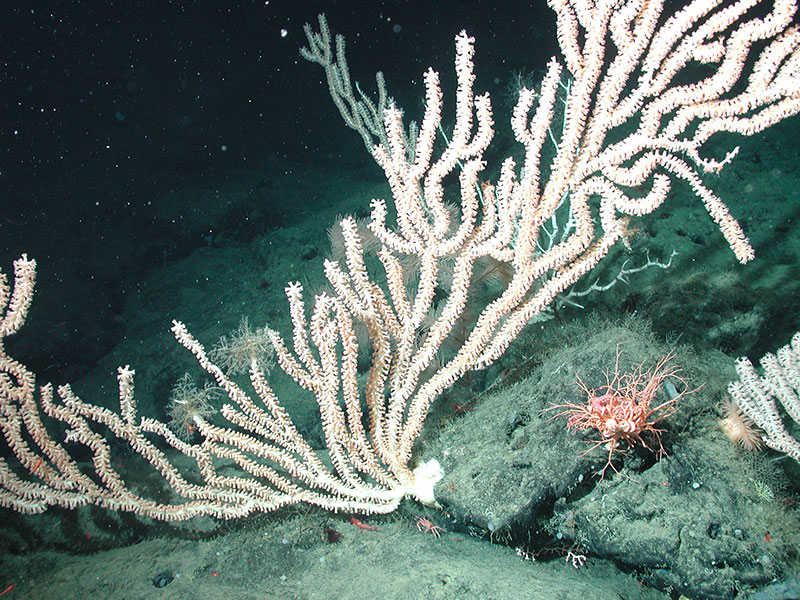
Deep-sea corals and sponges are the seamount’s primary structure-forming species., Based on recent surveys, they appear to be in pristine or near-pristine condition; however, historic information on the distribution and abundance of these resources is not available and information on current distribution, abundance and condition of these organisms is limited. In addition, it is unknown when global climate change (e.g., sea temperature rise, ocean acidification) will affect structure-forming species in the seamount environment. It is for these reasons that the condition of seamount’s biologically-structured habitats is rated “good” and the trend is “undetermined.”
Most of the organisms found at seamounts are large, sessile organisms, such as corals and sponges (Figure 59). ROV surveys to Davidson Seamount have recorded a variety of corals and sponges, including black corals (Order Antipatharia), soft corals (Order Alcyonacea), sea fans (Order Gorgonacea) and sponges (Phylum Porifera); approximately 22 coral and 24 sponge taxa in total (Burton and Lundsten 2008). Davidson Seamount’s invertebrate community at Davidson Seamount is dominated by passive suspension-feeding invertebrates (mostly corals) (Lundsten et al. 2009a). The hard rock substrate and elevated current velocities often found at the seamount appear to provide habitat favorable to sessile suspension and filter-feeding invertebrates.
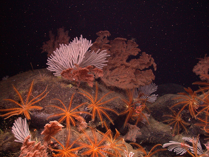
Large, sessile corals and sponges are used as a habitat by other organisms. They serve as hard substrate for attachment by other sessile organisms (e.g., basket stars, sea stars, scale worms, other corals, other sponges) and as shelter or food by some mobile organisms (e.g., fishes, skate egg cases, crabs, shrimps). There is increasing evidence that many areas of deep-sea coral and sponge habitats function as ecologically important habitats for fishes and invertebrates (Hourigan et al. 2007).
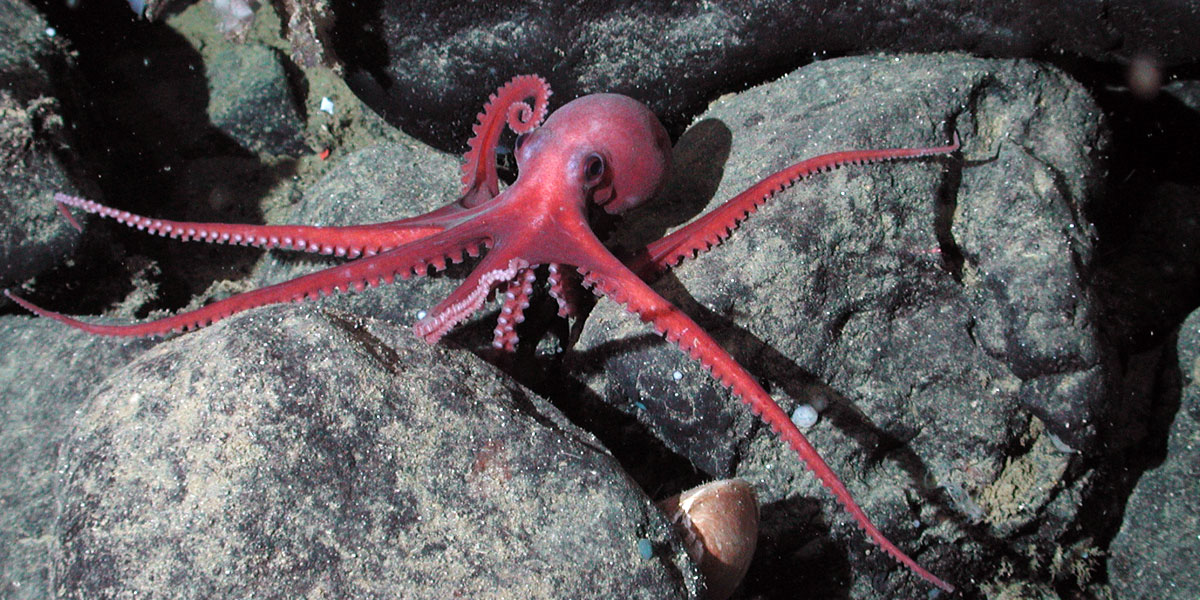
DeVogelaere et al. (2005) found that all of the deep-sea corals observed at Davidson Seamount (with the exception of Anthomastus) had other obvious megafauna associated with them. Polychaete worms, isopods, shrimps, crabs, basket stars, crinoids, brittle stars and anemones lived on the corals. Fauna observed adjacent to corals were grenadier (Coryphaenoides spp.), thornyheads (Sebastolobus sp.), sponges, other corals, sea stars, clams, sea cucumbers and octopi (Graneledone sp.).
Species assemblages at Davidson Seamount’s summit contain dense aggregations of corals and sponges (McClain et. 2009). These species also occur at similar depths along the rocky walls of Monterey Canyon, but at far lower densities or dominance, and they are smaller in size. These preliminary results suggest that the structure of seamount assemblages may differ from other deep benthic habitats and may prove to be source populations for many deep-sea species.
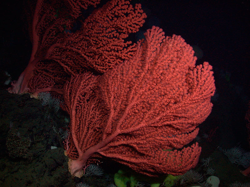
Bubble gum coral (Paragorgia spp.) are the most dramatic corals at Davidson Seamount due to their size (>2 x 2 meters in height and width) and dense aggregations ("forests") on local peaks and adjacent steep slopes (Figure 60) (DeVogelaere et al. 2005, Clague et al. 2010). Paragorgia arborea is considered to have a high rating of structural importance, due to its large size, branching morphology, many associations with other species and high relative abundance (Whitmire and Clarke 2007).
Age and growth studies of cold-water corals at Davidson Seamount indicate they are slow growing and long-lived (Andrews et al. 2005, 2007, 2009). Radiometric ageing results for two bamboo coral colonies (Keratoisis sp.) converged on a radial growth rate of ~0.055 millimeters per year (Figure 61). One colony was aged at 98 ± 9 years, with an average axial growth rate of ~0.7 centimeters per year. The age of a large colony was >145 years with an estimated axial growth rate of 0.14 to 0.28 centimeters per year. A linear (axial) growth rate of approximately 0.25 centimeters per year led to a colony age of about 115 years for the precious coral (Corallium sp.); however, based on the radial growth rate, an age of up to 200 years is possible (Figure 62). Due to the slow growth of these habitat-forming organisms, recovery from any damage could be slow (i.e., many decades to centuries).
These slow growing and long-lived structure-forming species are vulnerable to disturbances from human activities that impact the seafloor (see Table 2 for a summary of threats). Currently, the sanctuary’s seamount environment is well-protected from many activities that could alter the seafloor, such as bottom-contact fishing (see Seamount Question 5). And, to date, few activities have occurred on the seamount seafloor due to its remote nature (i.e., offshore and deep).
DSMZ is bisected by the shipping tracks of tankers that carry crude oil, black oil or other persistent liquid cargo in bulk (see Figure 57); however, spills from these ships will not likely impact benthic habitat. Another class of threat related to vessel traffic is the possibility for cargo from container ships to be lost at sea (MBNMS 2012). Impacts of lost cargo can include the threat of habitat crushing or smothering habitat and the introduction of foreign habitat structures. Cargo vessels transit the waters immediately adjacent to DSMZ (Figure 58), but there have been no known impacts to structure-forming species from lost cargo in DSMZ.
At present, sea temperature rise and ocean acidification appear to be two of the most severe threats to DSMZ (Table 2). Rogers et al. (2007) suggest changes in ocean chemistry resulting from climate change may result in large-scale changes in the faunal composition of seamount communities, especially where corals play a role in structuring the environment and providing habitats for other species. We are not aware of any temperature or pH impacts on the condition of structure-forming species at DSMZ, but there is very little information available. We need to monitor ocean temperature and chemistry, and the condition of structures-forming species.
7. What are the contaminant concentrations in sanctuary habitats and how are they changing?
Contaminant concentrations in the seamount environment are poorly understood. There have been very few sediment samples collected within DSMZ for the purpose of contaminant studies. As a result, the assessment of contaminant concentrations is “undetermined” with an “undetermined” trend.
It is known, however, that its depth and distance from land do not prevent the seamount environment from impacts from point and non-point water pollution (MBNMS 2012). For example, traces of the pesticide DDT, banned in the U.S. since 1972, but still present in watershed sediments, were detected in sediments near the base of the seamount and probably transported through Monterey Canyon sediment flow events (C. Paull, MBARI, unpub. data, Hartwell 2008). Further work is needed to understand contaminant concentrations, transport pathways and changes in contaminant concentrations over time.
8. What are the levels of human activities that may influence habitat quality and how are they changing?
Various existing and potential threats to Davidson Seamount’s habitat quality include: vessel traffic (e.g., loss of cargo, noise pollution); sunken vessels; military activity (e.g., dumping of dangerous waste, acoustic impacts to marine mammals); bio-prospecting; cumulative research collection; commercial harvesting (e.g., deep-sea fisheries, coral harvesting); oil and gas exploitation; mining; marine debris/dumping; underwater cables; sea temperature rise; and ocean acidification (see Table 2 for a comprehensive list of threats). The activity levels of many of these threats have not been quantified, and it is unknown if the cumulative level of these threats is changing. Therefore, this question is rated “good/fair” with an “undetermined” trend.
Davidson Seamount is one of the world’s few seamount areas to receive the level of protection afforded by Monterey Bay National Marine Sanctuary and NOAA Fisheries (see response to Seamount Question 5 for more details). Sanctuary regulations provide important – although not comprehensive – defenses against many of these identified threats to benthic habitat. Furthermore, the depth of Davidson Seamount’s summit, flanks (or slope) and base habitats make some forms of exploitation impossible or highly unlikely (MBNMS 2012).
Benthic habitats within DSMZ exhibit evidence of cumulative intentional and accidental dumping (MBNMS 2012, Schlining et al. 2013, DeVogelaere et al. 2014). During ROV surveys in 2002 and 2006, 44 pieces of marine debris were observed and documented (41% metal and 25% plastic). Specific items included bottles, cans, brooms, newspaper, buckets, curtains and a train wheel (Figure 63). The effects of pressure, temperature, darkness and relatively calm waters deep within DSMZ can preserve debris. The debris discovered thus far is likely proportional to sampling effort, and future research expeditions are bound to uncover additional materials of anthropogenic origin (MBNMS 2012).
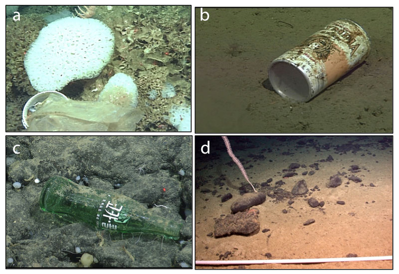
Some of the debris observed at the seamount was likely lost or dumped from large vessel transiting through DSMZ. The possibility of lost cargo containers is an additional threat to benthic habitat (MBNMS 2012). Impacts of lost cargo can include the threat of habitat crushing or smothering and the introduction of foreign habitat structures (see Offshore Question 5 and Figure 40). Cargo vessels transit the waters immediately adjacent to the DSMZ (see Figure 58), but there have been no known impacts to habitat from lost cargo in DSMZ.
During a 2006 ROV dive survey, researchers discovered a telecommunications cable that runs along the side of the seamount (Figure 63d) (MBNMS 2012). The history and current status of the cable is unknown. Submarine cables could become destructive to biogenic habitats (e.g., corals and sponges), if they become mobile.
At present, sea temperature rise and ocean acidification appear to be two of the most severe threats to DSMZ (Table 2). Rogers et al. (2007) suggest changes in ocean chemistry resulting from climate change may result in large-scale changes in the faunal composition of seamount communities, especially where corals play a role in structuring the environment and providing habitats for other species. We are not aware of temperature or pH impacts on the condition of structure-forming species at DSMZ, but there is very little information available. Sea temperature rise and ocean acidification are global phenomena and require regulation at larger geographical scales beyond the jurisdiction of sanctuary management (MBNMS 2012); however, making note of them here will allow managers within and beyond the sanctuary to anticipate and respond to these pressures.
Seamount Environment Habitat Status and Trends
Status: Good Good/Fair Fair Fair/Poor Poor Undet.
Trends:
▲ Conditions appear to be improving.
- Conditions do not appear to be changing.
▼ Conditions appear to be declining.
? Undeterminted trend.
N/A Question not applicable.
| # | Issue | Rating | Confidence | Basis For Judgement | Description of Findings |
|---|---|---|---|---|---|
| 5. | Abundance/ Distribution |

|
Status: Very High Trend: Very High |
Offshore location, existing level of protections and limited access to the seafloor may limit impacts. | Habitats are in pristine or near-pristine condition and are unlikely to preclude full community development. |
| 6. | Biologically- Structured |
Status: Very High Trend: Medium |
Biogenic species appear abundant; organisms larger, more robust than coastal canyon areas. Trend information unavailable. | Habitats are in pristine or near-pristine condition and are unlikely to preclude full community development. | |
| 7. | Contaminants | Status: N/A Trend: N/A |
Contaminant concentrations in DSMZ are poorly understood. There have been very few sediment samples collected within DSMZ for the purpose of contaminant studies. | Not enough information to make a determination. | |
| 8. | Human Impacts | Status: High Trend: Medium |
Harmful activities exist, but offshore location, existing level of protections and limited access to the seafloor may limit impacts. | Some potentially harmful activities exist, but they do not appear to have had a negative effect on habitat quality. |
Seamount Environment: Living Resources
Biodiversity is variation of life at all levels of biological organization, and commonly encompasses diversity within a species (genetic diversity) and among species (species diversity), and comparative diversity among ecosystems (ecosystem diversity). Biodiversity can be measured in many ways. The simplest measure is to count the number of species found in a certain area at a specified time; this is termed species richness. Other indices of biodiversity couple species richness with a relative abundance to provide a measure of evenness and heterogeneity. When discussing biodiversity, we primarily refer species richness and to diversity indices that include relative abundance of different species and taxonomic groups. To our knowledge, no species have become extinct within the sanctuary; therefore, native species richness remains unchanged since sanctuary designation in 1992. Researchers have described previously unknown species (i.e., new to science) in deeper waters, but these species existed within the sanctuary prior to their discovery. The number of non-indigenous species has increased within the sanctuary; however, we do not include non-indigenous species in our estimates of native biodiversity.
Key species, such as keystone species, indicators species, sensitive species and those targeted for special protection, are discussed in the responses to questions 12 and 13. Status of key species will be addressed in question 12 and refers primarily to population numbers. Condition or health of key species will be addressed in question 13. The sanctuary’s key species are numerous and cannot all be covered here. Instead, in this report, we emphasize various examples from the sanctuary’s primary habitats that have data available on status and/or condition.
The following information provides an assessment of the current status and trends of the sanctuary’s living resources in the seamount environment.
9. What is the status of biodiversity and how is it changing?
In recent history, it is unlikely that species have become locally extinct or that species richness has declined in the marine ecosystem within DSMZ. Some baseline information on local biodiversity has been collected by surveys of the seafloor and sea surface. For these reasons, the status of biodiversity in the seamount environment is rated as “good” with an “undetermined” trend.
Seamount Benthos
In 2002 and 2006, the sanctuary led two multi-institutional expeditions to characterize the geology and natural history of Davidson Seamount. Approximately 140 hours of video and samples were collected during 17 remotely operated vehicle (ROV) dives. Most dives were primarily on the seafloor, with opportunistic dives in the water column above the seamount. At least 237 taxa were observed, including 18 previously undescribed species (Burton and Lundsten 2008, E. Burton, MBNMS, unpubl. data).
The Davidson Seamount is a relatively pristine area populated by a diversity of cold-water corals, most of which have other species associated with them (see Seamount Environment Habitat Question 6) (DeVogelaere et al. 2005). While most of the corals were found on the seamount’s highest peaks, others were found deeper, and still, almost exclusively on ridge formations.
Species assemblages at the seamount summit contain dense aggregations of corals and sponges (McClain et al. 2009). These species are encountered at similar depths along rocky walls of Monterey Canyon, but at far lower densities or dominance, and they are smaller in size. Preliminary results suggest that structure of seamount assemblages may differ from other deep-sea benthic habitats and prove to be source populations for many deep-sea species.
Species diversity and density at Davidson Seamount do not significantly change with depth, and can vary greatly on a single isobath (McClain et al. 2010). Authors suggest the lack of clear bathymetric pattern in diversity or density may reflect the proximity of Davidson Seamount to highly productive coastal waters fueled by coastal upwelling. However, changes of 50% in assemblage composition were observed over a ~1,500 meter depth interval down the flanks of the seamount (McClain et al. 2010).
Seamount Sea Surface
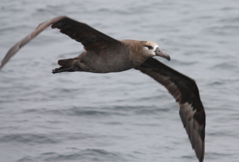
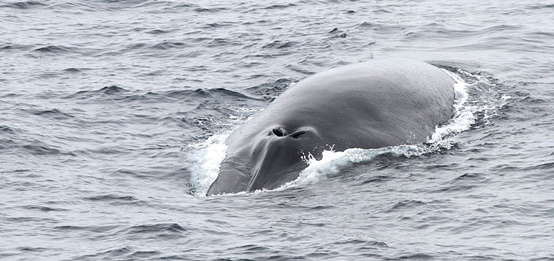
Several ship-based and aerial surveys have taken place at Davidson Seamount to determine the occurrence of marine mammals, seabirds or surface-swimming fishes (Figure 64) (Benson 2002, Forney 2002, King 2010, Newton and DeVogelaere 2013). The majority of these surveys were opportunistic, and limited in range or duration. In July 2010, sanctuary staff and regional experts conducted a dedicated, ship-based survey of the waters above and around the Davidson Seamount. Eight transect lines were surveyed for a total of 605 kilometers of “on-effort” observations. Seventeen species of seabirds and six marine mammal species were observed (Newton and DeVogelaere 2013). Overall, 200 sightings of 668 individual marine mammals were counted during the three day survey. Fin whales (Balaenoptera physalus) were the most commonly encountered marine mammal (51% of all marine mammal sightings) (Figure 65). Additionally, there were 316 sightings of 1,033 individual seabirds comprising 17 different species. Cook’s petrel (Pterodroma cookii) and Leach’s storm-petrel (Oceanodroma leucorhoa) were the two most commonly encountered species (77% of seabird sightings and 82% of all seabirds observed). Including off effort sightings, observers recorded the greatest number of Cook’s petrel ever observed in California waters (5,125 total birds).
10. What is the status of environmentally sustainable fishing and how is it changing?
We no longer assess this question in ONMS condition reports; therefore, content for this question was not included.
11. What is the status of non-indigenous species and how is it changing?
There are no known non-indigenous species within the seamount environment (Burton and Lundsten 2008, Lundsten et al. 2009a, 2009b). Non-indigenous species in offshore habitats are not suspected or do not appear to affect ecosystem integrity because very few non-indigenous species have been identified in these habitats. Hence, this question is rated “good” and the trend is “not changing.”
12. What is the status of key species and how is it changing?
The status of key species in the offshore environment is rated “good/fair” and the trend is “increasing.” Key species include cold-water corals (biogenic species), marine mammals (i.e., fin whale) and fisheries-targeted pelagic fishes (i.e., albacore, swordfish, common thresher shark). Cold water corals (biogenic habitat) may represent indicators of ecosystem condition or change, marine mammals are considered charismatic species and pelagic fishes are key species due to their important role in commercial and recreational fisheries. While coral species appear to reflect near-pristine conditions, whale and fished species do not, leading to a good/fair rating.
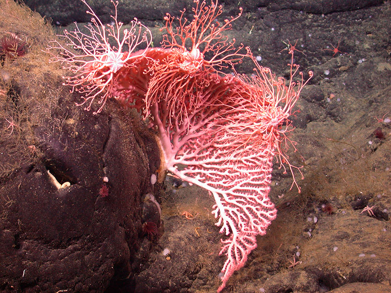
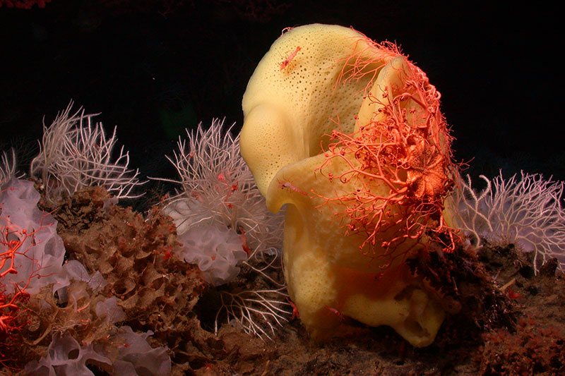
Biogenic Species
Structure-forming invertebrates at Davidson Seamount, such as the many species of cold-water corals and sponges, hold an important ecological role to create habitat structure for other species (Figure 66). All of the deep-sea corals observed at Davidson Seamount (with the exception of Anthomastus) had other obvious megafauna associated with them (DeVogelaere et al. 2005). Polychaete worms, isopods, shrimps, crabs, basket stars, crinoids, brittle stars and anemones lived on the corals. Present adjacent to corals were grenadier (Coryphaenoides spp.), thornyhead (Sebastolobus sp.), sponges, other corals, seastars, clams, sea cucumbers and octopi (Graneledone sp.).
Credit: NOAA/MBARI
Observations from Davidson Seamount show that summit assemblages contain dense aggregations of corals and sponges (McClain et al. 2009). These species are encountered at similar depths along the rocky walls of Monterey Canyon, but at far lower densities or dominance than at Davidson Seamount. Lundsten et al. (2010) identified 25 coral species at Davidson Seamount. The Gorgonacea (e.g., bubble gum corals, Paragorgia spp.) were the most frequently observed coral group (73%) and encompassed the widest depth range. Other coral groups included Antipatharians (black corals, 21.8%), Alcyonacea (4.7%), Scleractinia (0.4%), Zoanthidea (0.09%) and Pennatulacea (0.07%).
Bubble gum corals (Paragorgia spp.) are the most dramatic corals observed at Davidson Seamount due to their size (>2 x 2 meters in height and width) and dense aggregations ("forests") on local peaks and adjacent steep slopes (DeVogelaere et al. 2005, Clague et al. 2010). These corals are thought to reach the largest size of any sedentary colonial animal (Hourigan et al. 2007). For example, colonies of Paragorgia arborea in New Zealand have been reported to reach 10 meters in height (Smith 2001, Hourigan et al. 2007).
Age and growth studies of cold-water corals at Davidson Seamount indicate they are slow growing and long-lived, with some colonies aged at over 100 years old (see Seamount Question 6 for more details) (Andrews et al. 2005, 2007, 2009). Due to their large size and slow growth, deep-sea corals and sponges are vulnerable to disturbance from human activities that contact the seafloor. Sanctuary regulations prohibit the take of corals, unless permitted for research purposes. In addition, the seamount is protected from bottom fishing gear through essential fish habitat designation. Therefore, coral removal is unlikely and closely regulated.
Marine Mammals
Several ship-based and aerial surveys have taken place at Davidson Seamount to determine the occurrence of marine mammals, seabirds or surface-swimming fishes (Benson 2002, Forney 2002, King 2010, Newton and DeVogelaere 2013). The majority of these surveys were opportunistic, and limited in range or duration. In July 2010, the first dedicated, multi-disciplinary survey of marine mammal, seabird and oceanographic conditions at the Davidson Seamount happened (Newton and DeVogelaere 2013). During the three day ship-based survey, there were 200 sightings of 668 individual marine mammals (Newton and DeVogelaere 2013). Fin whales (Balaenoptera physalus) were the most commonly encountered marine mammal (51% of all marine mammal sightings). The California/Oregon/Washington fin whale stock is listed as federally endangered, and there is some indication that the population may be growing (Carretta et al. 2013). While we have less information on other marine mammals in the area, the following species have also been observed: Dall’s porpoise (Phocoenoides dalli), Pacific white-sided dolphin (Lagenorhynchus obliquidens) and northern right whale dolphin (Lissodelphis borealis) (Newton and DeVogelaere 2013).
Fisheries-Targeted Species
In recent years, two commercial finfish fisheries have operated in the top 150 feet (46 meters) of water above Davidson Seamount to target highly migratory pelagic species: (1.) drift gillnetting for swordfish and sharks, and (2.) trolling for albacore (NOAA 2008, MBNMS 2012). Swordfish and pelagic sharks are primarily caught with drift gillnets. Albacore (Thunnus alalunga) are caught both commercially and recreationally by trolling lures or live bait. Fishermen have reported that the seamount may enhance albacore fishing in certain years (NOAA 2004, MBNMS 2012). The seamount itself is too deep for most fish trawling methods, where fish density is very low, and with the exception of thornyhead, the species seen to date are not commercially desirable.
The North Pacific albacore stock area consists of all waters in the Pacific Ocean north of the equator (ALBWG 2014). Estimates of total stock biomass (age-1 and older) show a long term decline from the early 1970s to 1990, followed by a recovery through the 1990s and subsequent fluctuations without trend in the 2000s. Based on the results of the stock assessment, the North Pacific albacore stock is not experiencing overfishing and probably not in an overfished condition. The Albacore Working Group (ALBWG) concludes that the North Pacific albacore stock is healthy and that current productivity is sufficient to sustain recent exploitation levels, assuming average historical recruitment in both the short and long-term.
The North Pacific common thresher shark (Alopias vulpinus) stock has not been fully assessed. The U.S. West Coast Exclusive Economic Zone (EEZ) regional catch and catch per unit effort (CPUE) suggests the population is increasing from estimated low levels in the early 1990s (PFMC 2014).
The northeast Pacific’s swordfish (Xiphias gladius) stock is healthy, is not overfished, overfishing is not occurring and biomass is greater than the biomass at which maximum sustainable yield (MSY) is produced (Marsh and Stiles 2011, ISC 2014).
13. What is the condition or health of key species and how is it changing?
The condition or health of key species in the offshore environment is rated “good” and the trend is “not changing.” The health of coral and other biogenic species seems good. There are some concerns about impacts of ocean chemistry changes on these species, but further study is needed to determine if there have been any impacts to populations at Davidson Seamount. The response to Offshore Question 13 provides a general summary of health concerns for marine mammals in the offshore waters, including entanglement in and ingestion of marine debris and the bioaccumulation of contaminants. There are some DSMZ-specific threats to marine mammal health (e.g., vessel traffic, noise), but little data is available to assess impacts of those threats in DSMZ. Fisheries-targeted species (e.g., albacore, swordfish, thresher shark) have no known DSMZ-specific health issues. These long-lived fishes can have elevated levels of contaminants, such as mercury, but DSMZ is not a source of those contaminants.
Biogenic Species
Age and growth studies of cold-water corals at Davidson Seamount indicate they are slow growing and long-lived (Andrews et al. 2005, 2007, 2009). Radiometric ageing results for two bamboo coral colonies (Keratoisis sp.) converged on a radial growth rate of ~0.055 millimeters per year. One colony was aged at 98 ± 9 years, with an average axial growth rate of ~0.7 centimeters per year. The age of a large colony was >145 yearswith an estimated axial growth rate of 0.14 to 0.28 centimeters per year. A linear (axial) growth rate of approximately 0.25 centimeters per year led to a colony age of about 115 years for the precious coral (Corallium sp.); however, based on the radial growth rate, an age of up to 200 year is possible. Due to the slow growth of these habitat-forming organisms, recovery from any damage could be slow (i.e., many decades to centuries).
Bubblegum corals’ growth rates are not well-defined (Hourigan et al. 2007). Age estimates using skeletal cross sections from one Davidson Seamount colony (Paragorgia arborea) (80 centimeters from base to tip along main axis) suggest 9 to 14 years (Andrews et al. 2005). When translated to a linear growth rate, the estimate is relatively high: 6-9 centimeters per year. However, counting of these growth zones was very subjective and should be interpreted with caution. Radiocarbon-dating of a very large New Zealand Paragorgia arborea colony resulted in preliminary age estimates ranging between 100-200 years for the tip of the colony, and between 300-500 years for the base of the colony (Tracey et al. 2003).
Sanctuary regulations prohibit the take of corals, unless permitted for research purposes. In addition, the seamount is protected from bottom fishing gear in essential fish habitat. Therefore, coral removal is unlikely and closely regulated.
Marine Mammals
Vessel traffic can cause health concerns for key marine mammal species. The northeast corner of DSMZ is bisected by shipping tracks of tankers that carry crude oil, black oil or other persistent liquid cargo in bulk (see Figure 57). Threats from vessel traffic include oil or chemical spills, loss of cargo, ship-based pollution (i.e., residues from tank cleaning), exchange of ballast water and noise pollution.
Additionally, low frequency sounds produced by vessels have acoustic impacts that are not confined to coastal waters, but penetrate deep waters (MBNMS 2012). Impacts from this type of pollution remain uncertain for cetaceans and other species that spend a large part of their life in deep waters and use sound to communicate, navigate, feed and sense their environment (UNEP 2007).
14. What are the levels of human activities that may influence living resource quality and how are they changing?
Although there are some existing and potential threats to living resources, Davidson Seamount is one of the world’s few seamount areas to receive the level of protection afforded by Monterey Bay National Marine Sanctuary and NOAA Fisheries. Sanctuary regulations provide important – although not comprehensive – defenses against various threats. Furthermore, the great depth of Davidson Seamount’s summit, flanks (or slope) and base habitats make some forms of exploitation impossible or highly unlikely (MBNMS 2012). Nonetheless, as previously noted, there are various levels of existing and potential threats (see Table 2 for a full list of potential threats and their ratings). The activity levels of most of the existing threats have been qualitatively described in DSMZ. Conversely, some potentially harmful activities exist (i.e., vessel traffic, marine debris, sea temperature rise, ocean acidification), but they do not appear to have had a negative effect on living resource quality. Given all of these factors, we do not know if the cumulative activity level has changed. Therefore, this question is rated “good/fair” with an “undetermined” trend.
At present, vessel traffic, marine debris, sea temperature rise and ocean acidification appear to be the most severe threats to living resources in DSMZ (MBNMS 2012). Marine debris has been found on the seafloor in DSMZ and may negatively impact benthic organisms (see Seamount Question 8 for more details). Floating marine debris impacts pelagic animals in many ways, most notably through entanglement and ingestion of plastic fragments that can clog the digestive tract (see Offshore Questions 13 and 14 for more details). However, the amount of marine debris in DSMZ, particularly in the water column, is not well understood.
Threats to living resources from vessel traffic include oil or chemical spills and discharges, loss of cargo and other marine debris, ship-based pollution (i.e., residues from tank cleaning), exchange of ballast water, ships colliding with whales and other large animals and noise pollution (MBNMS 2012). The northeast corner of DSMZ is bisected by the Western States Petroleum Association (WSPA) recommended shipping tracks for tankers carrying crude oil, black oil or other persistent liquid cargo in bulk (see Figure 57). Miller (2011) found that the average number of vessel transits through DSMZ in 2010 was 159 per month. An analysis of vessel traffic (2009-2012) indicates a great majority of the large vessels that transit in or near MBNMS comply with the WSPA and International Maritime Organization (IMO) recommended tracks (see Figure 58) (De Beukelaer et al. 2014). It would be useful to look at the trends in AIS data for the number of vessels that transit through DSMZ on a monthly or annual basis. One emerging threat to the Davidson Seamount’s living resources is the impacts of changing ocean chemistry on both plankton and benthic structure-forming species, many of which have calcified body parts. We are not aware of specific studies of impacts of acidification on living resources in DSMZ. Directed study of the effects of climate driven changes in pH, temperature and dissolved oxygen on key species in DSMZ will become increasingly important to understand and track the status and condition of living resources. Sea temperature rise and ocean acidification are global phenomena and require regulation at larger geographical scales beyond the jurisdiction of sanctuary management (MBNMS 2012); however, making note of them here will allow managers within and beyond the MBNMS to anticipate and respond to these pressures.
Seamount Living Resources Status and Trends
Status: Good Good/Fair Fair Fair/Poor Poor Undet.
Trends:
▲ Conditions appear to be improving.
- Conditions do not appear to be changing.
▼ Conditions appear to be declining.
? Undeterminted trend.
N/A Question not applicable.
| # | Issue | Rating | Confidence | Basis For Judgement | Description of Findings |
|---|---|---|---|---|---|
| 9. | Biodiversity | Status: Very High Trend: Medium |
Relatively pristine area with few removals; but data are sparse. | Biodiversity appears to reflect pristine or near-pristine conditions and promotes ecosystem integrity (full community development and function). | |
| 11. | Non-Indigenous Species |
|
Status: Medium Trend: Medium |
No known non-indigenous species; but data are sparse. | Non-indigenous species are not suspected or do not appear to affect ecosystem integrity (full community development and function). |
| 12. | Key Species Status | Status: High Trend: High |
Abundance and diversity of corals, stable fish stocks and existing protections. Federally endangered marine mammal populations (e.g., Fin whale), appear to be increasing. | Key and keystone species appear to reflect pristine or near-pristine conditions and many promote ecosystem integrity (full community development and function). | |
| 13. | Key Species Condition |
|
Status: High Trend: Medium |
Key species appear healthy, and are protected or otherwise regulated. | The condition of key resources appears to reflect pristine or near-pristine conditions. |
| 14. | Human Activities | Status: High Trend: Medium |
Offshore location, existing level of protections and few existing threats may limit impacts to living resources. | Some potentially harmful activities exist, but they do not appear to have had a negative effect on habitat quality. |
Seamount Environment: Maritime Archaeological Resources
The following information provides an assessment of the current status and trends of the maritime archaeological resources in the offshore environment.There are no known maritime archaeological resources within Davidson Seamount Management Zone; therefore, questions 15-17 are not applicable to this environment.
15. What is the integrity of known maritime archaeological resources and how is it changing?
There are no known maritime archaeological resources within Davidson Seamount Management Zone.
16. Do known maritime archaeological resources pose an environmental hazard and is this threat changing?
There are no known maritime archaeological resources within Davidson Seamount Management Zone.
17. What are the levels of human activities that may influence maritime archaeological resource quality and how are they changing?
There are no known maritime archaeological resources within Davidson Seamount Management Zone.
Seamount Environment Maritime Archaeological Resources Status and Trends
Status: Good Good/Fair Fair Fair/Poor Poor Undet.
Trends:
▲ Conditions appear to be improving.
- Conditions do not appear to be changing.
▼ Conditions appear to be declining.
? Undeterminted trend.
N/A Question not applicable.
| # | Issue | Rating | Confidence | Basis For Judgement | Description of Findings |
|---|---|---|---|---|---|
| 15. | Integrity | Status: N/A Trend: N/A |
No known maritime archaeological resources. | N/A | |
| 16. | Threat to Environment | Status: N/A Trend: N/A |
No known maritime archaeological resources. | N/A | |
| 17. | Human Activities | Status: N/A Trend: N/A |
No known maritime archaeological resources. | N/A |