State of Sanctuary Resources: Offshore Environment
Monterey Bay National Marine Sanctuary

The offshore environment, which extends from a depth of 30 meters to the seaward boundary, contains the majority of the seafloor and open water habitat in MBNMS (see Figure 1). The seafloor in this environment ranges in depth from 30 meters down to over 3,000 meters at its deepest point in the sanctuary, and includes the outer continental shelf, slope, rise and submarine canyons. The open water — three-dimensional habitats not associated with the seafloor — has a total volume of 12.026 trillion cubic meters or approximately 4.8 billion Olympic-sized swimming pools. Open water can be subdivided into three zones by depth. First, the epipelagic zone, which includes the upper 200 meters of the water column, comprises 18% of the open water habitat. Second, the mesopelagic zone, from 200 to 1,000 meters, makes up nearly half of the open water. Third, the remaining 35% of the open water’s volume is deeper than 1,000 meters and is called the bathypelagic zone.
Generally, less information is available for the offshore environment than the nearshore environment. This is due in part to the fact the offshore environment covers a much larger area of seafloor and possesses a greater volume of water than the nearshore environment. Moreover, we must overcome more logistical and economic hurdles to study the offshore environment. Offshore research often requires large vessels to deploy nets, remotely operated vehicles or submersibles to sample and explore the vast volume of water and deep seafloor habitats. Nevertheless, it is widely recognized that the offshore ecosystem’s productivity supports a great diversity and abundance of invertebrates, fishes, seabirds and marine mammals. Although often limited in spatial coverage or frequency of sampling, we have used the most recent data and best available local information to summarize the status of the sanctuary’s offshore environment.
Most of the regularly monitored key species and species assemblages in the offshore environment appear to be stable. The number of native species in offshore habitats, one measure of biodiversity, appears to be stable with no known losses of native species, and no species introductions are known to have occurred. Bottom trawl fishing – the most extensive impact to offshore benthic habitat – has decreased in intensity and spatial extent. Furthermore, bottom trawlers have switched to less damaging gear and moved to less sensitive habitats therefore, we expect the recovery of formerly impacted habitats and structure-forming species.
Pollutants (e.g., PCBs), marine debris and toxins from Harmful Algal Blooms (HABs) are detected in some key offshore species. There are concerns about impacts to sensitive species from human-caused noise, vessel traffic, and entanglements in buoy lines and lost and active fishing gear. The recent prevalence of unusually warm water along the U.S. West Coast has altered the distribution and abundance of some temperature-sensitive species and led to stranding events for a couple of key species; however, we need more time to determine if this phenomenon will have any persistent impacts on the structure and function of the offshore ecosystem or key species. Impacts from climate change, including acidification, warming and shoaling of the oxygen minimum zone, are starting to be detected, but we require additional research and monitoring to better understand and predict current and future impacts.
Offshore Environment: Water Quality
The focus of the offshore water quality section of this report is the change in the quality of open water habitats. The quality of these open water habitats is influenced by natural and anthropogenic factors. The recent patterns in natural cycles (e.g., El Niño Southern Oscillation, Pacific Decadal Oscillation) are reviewed in our response to question 1 below. The timing of the 2015 Condition Report Update, and how it aligns with these natural cycles, may have some influence on the apparent health of sanctuary resources, especially water quality and living resources. When long-term monitoring information is available, we have tried to account for whether the current conditions of sanctuary resources are within the range expected due to the natural fluctuations in climate and ocean conditions.
The following information provides an assessment of the current status and trends of offshore water quality and its effects on habitat and living resources in that environment.
1. Are specific or multiple stressors, including changing oceanographic and atmospheric conditions, affecting water quality?
Stressors on the offshore environment’s water quality, specifically changing ocean conditions, pollutants and toxin-producing harmful algal blooms (HABs), may inhibit the development of assemblages and may cause measurable declines in some living resources and habitats. For this reason, the rating in the 2009 condition report was "fair" with a "declining" trend. The 2015 status for stressors in offshore waters remains "fair" and "declining" based on changing ocean chemistry, increasing levels of pollutants (detailed in Offshore Questions 3 and 7) and continued occurrence of toxin-producing HABs (details in Offshore Question 2), all of which have measurable impacts to offshore water quality and appear to influence the health and composition of pelagic faunal communities.
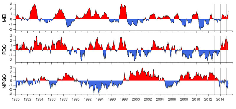
Over the last few decades, extensive research has improved our understanding of the natural cycles in oceanographic and atmospheric conditions that occur in the eastern Pacific Ocean, such as the El Niño Southern Oscillation (ENSO) and the Pacific Decadal Oscillation (PDO). Time series data describe recent conditions relative to these natural cycles; however, fluctuations in offshore conditions relative to natural cycles are not the basis for the fair and declining trend. Instead, the ratings are based on stressors linked to human activities which are not part of the system’s natural cycling, such as inputs of pollutants and global climate change. We discuss these stressors after a brief summary of natural variation in climate and ocean conditions.
Oceanographic monitoring data collected by the Monterey Bay Aquarium Research Institute (MBARI) shows that the period from 2009-2013 was mostly productive during a cool phase of the Pacific Decadal Oscillation (PDO), which is associated with strong upwelling, cooler sea surface temperatures and some very high chlorophyll anomalies (Figure 37) (F. Chavez, MBARI monitoring data). These cooler productive conditions are linked to a high abundance of many forage groups, including krill and young-of-the-year fishes (see Offshore Questions 9 and 12 for additional detail), and can help support higher reproductive success of locally breeding seabirds and pinnipeds, higher seasonal abundance of foraging baleen whales and migratory seabirds and higher productivity of juvenile and adult salmon (Santora et al. 2012, Wells et al. 2012).
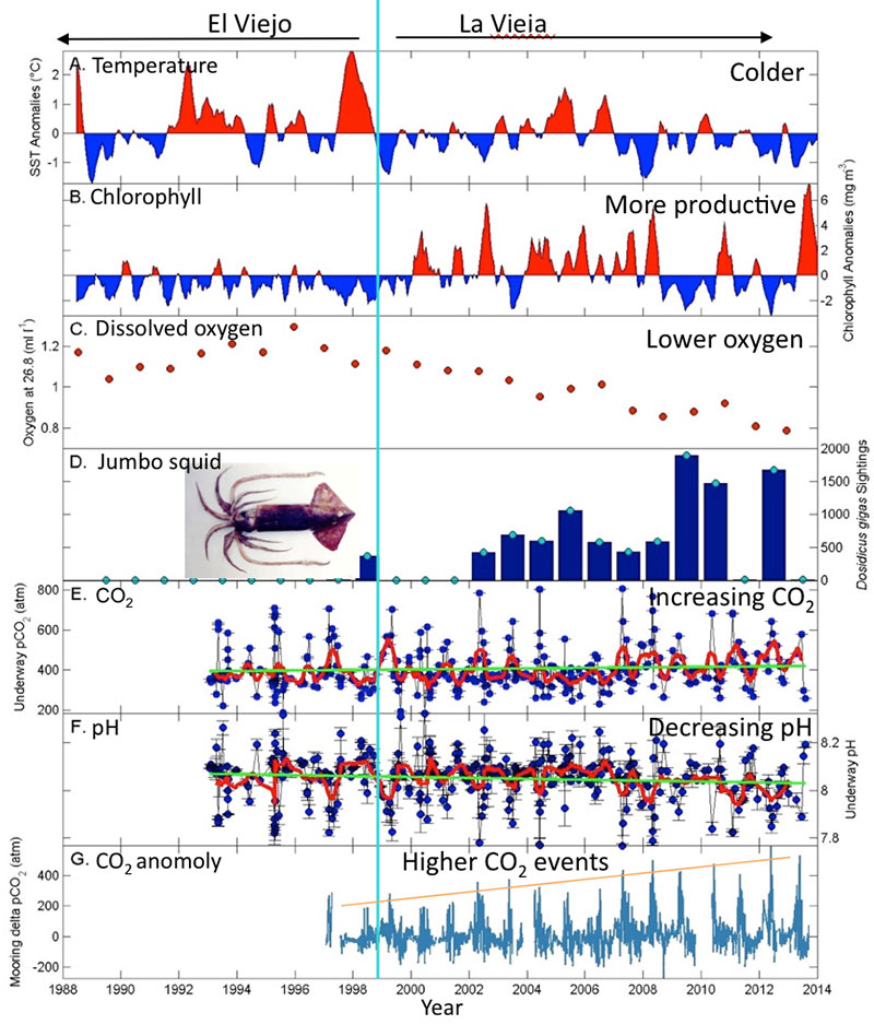
Starting in 2014, sea surface temperatures were anomalously high all along the U.S. West Coast. At the M1 buoy in Monterey Bay, unusually high sea surface temperatures (2-4ºC higher than usual) began in August 2014 and persisted into 2015. The Multivariate ENSO Index (MEI), PDO index and North Pacific Gyre Oscillation (NPGO) (Figure 38), all of which can be used to track climate and ocean conditions in the North Pacific Basin, shifted from conditions that generally promote high primary productivity in 2008-2013 to less productive conditions in 2014 (Harvey et al. 2014, Hazen et al. 2014). Decreased upwelling, warm temperatures and decreased productivity in 2014 and early 2015 have likely affected the abundance and distribution of some types of forage fish and invertebrates and resulted in mass strandings of emaciated Cassin’s auklets and California sea lions (see Offshore Question 13 for more information). The unusually warm water also coincided with increased sightings of warmer water species (e.g., tropical sea butterflies [pteropods], blue buoy barnacles, a green sea turtle and common dolphins) not usually observed in MBNMS, except during El Niño events. If the warming persists far into 2015, some of the species that do well in a colder, more productive ocean could experience reduced growth, poor reproductive success and population declines. At the same time, species that do well in warmer conditions may experience increased growth, survival and abundance. We will need a few more years of observation to determine if this is a short-term anomaly (possibly due to El Niño) or the beginning of a longer-term shift to a warm phase of the PDO.
Graph: I. Schroeder, NMFS-SWFSC
Despite the fact that most of the period from 2009-2014 has been productive for the sanctuary, continuing shifts in ocean chemistry due to global climate change are leading to increasingly stressful conditions for many species in the offshore environment (reviewed in Doney et al. 2012). Oceanographic monitoring data collected by MBARI in Monterey Bay’s offshore waters (Figure 37) show that ocean CO2 is increasing while pH and dissolved oxygen are decreasing (F. Chavez, MBARI monitoring data). Ocean acidification describes a decrease in ocean pH levels caused by an increase in dissolved CO2. The natural process of upwelling that occurs along the central California coast already results in a high amount of dissolved CO2 in this area because upwelling brings CO2-rich waters from the deep ocean to the shelf environment. Human-caused CO2 adds to the overall level of dissolved CO2 in these waters and could exacerbate ocean acidification in the offshore environment (Doney et al. 2012).
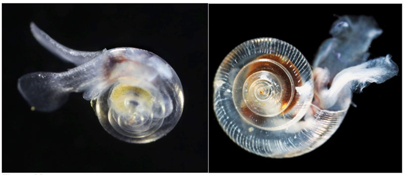
Ocean acidification is a stressor on marine organisms, particularly those with body parts made of calcium carbonate. Phytoplankton and zooplankton are the base of the pelagic food web, and many types of phytoplankton and zooplankton have calcium carbonate shells that are vulnerable to dissolution from increasing acidity. For example, a recent study of pteropods’ shell thickness (planktonic snails) (Figure 39) along the U.S. West Coast found the incidence of severe shell dissolution has more than doubled relative to pre-industrial conditions (Bednarsek et al. 2014). The authors project that severe shell dissolution could increase to as much as 70% by 2050 in the central onshore region of the California Current Ecosystem, which includes MBNMS’s entire coast out to the 200 meter isobath. Pteropods are important prey for a number of pelagic species including salmon, mackerel and herring, and reductions in this food source could affect other components of the pelagic food web.
Another potential stressor to inhabitants of deep shelf and slope habitats is a shoaling of the oxygen minimum zone (Gilly et al. 2013). The oxygen minimum zone (OMZ) is a midwater depth range where the oxygen concentration is less than 20 micromole per kilogram in the Pacific. In the sanctuary, the OMZ typically occurs at depths from 600 to 1000 meters. Oxygen concentration in the water column rapidly decrease approaching the OMZ’s upper boundary, continues to decline until a minimum is reached in the middle of the OMZ and then gradually increases with depth to the OMZ’s lower boundary and beyond. The OMZ influences both the vertical distribution of pelagic fauna, and where the OMZ intersects the seafloor, the depth distribution of benthic fauna (Gilly et al. 2013). Shoaling of the upper OMZ boundary has been observed over the past several decades in the eastern Pacific (Bograd et al. 2008). Shoaling of the OMZ is causing vertical habitat compression for those species that occur in waters above the upper OMZ boundary and cannot tolerate reduced oxygen levels. These species may respond to shoaling of the OMZ with a shift in vertical distribution to shallower depths, while those species that reside within the OMZ will experience a vertical expansion of their habitat (Gilly et al. 2013). For example, the shoaling of the OMZ has been associated with a reduction in abundance of mesopelagic fish larvae possibly due to mesopelagic fishes having to move to shallower depths which makes them more vulnerable to visually oriented predators (Koslow et al. 2011). OMZ shoaling may also restrict usable habitat for high trophic level, migratory fishes (e.g., swordfish, sharks and tunas) and make them more vulnerable to surface fishing gear, as has been observed in the tropical northeast Atlantic Ocean (Stramma et al. 2012). The northern expansion of the jumbo squid’s range along the west coast of North America also appears to be facilitated by shoaling of the OMZ (Stewart et al. 2014).
2. What is the eutrophic condition of sanctuary waters and how is it changing?
Experts agree that the eutrophic condition in the offshore environment rating remains “good/fair” because monitoring data suggests that selected conditions may preclude full development of living resource assemblages and habitats, but are not likely to cause substantial or persistent declines. The 2009 “declining” trend continues to be supported by additional evidence of nutrient enrichment and increasing frequency and intensity of harmful algal blooms in selected areas.
Two types of marine HABs pose the most significant threats to California’s coastal ecosystem. First, dinoflagellates of the genus Alexandrium cause paralytic shellfish poisoning (PSP). Second, diatoms of the genus Pseudo-nitzschia produce domoic acid (DA), which causes amnesic shellfish poisoning (ASP) in humans. Other less common HABs, which may occur more frequently in the future, include: Cochlodinium, Akashiwo sanguinea and Dinophysis (Lewitus et al. 2012).
In most areas along the West Coast, there is little evidence to support anthropogenic factors as the primary cause of Alexandrium blooms. In California, blooms are strongest in the drier seasons, and typically appear offshore, and move onshore when upwelling relaxes (Langois and Smith 2001, Anderson et al. 2008). Research on phytoplankton productivity in ammonium-rich discharges from San Francisco Bay indicate there is a possibility that elevated ammonium levels prevent nitrate uptake by diatoms, which then allows dinoflagellates to bloom (Glibert et al. 2011); however, Kudela et al. (2010) showed that ammonium is a nutrient source for Pseudo-nitzschia. Specifically, Kudela et al. looked at nutrient use by harmful algae in upwelling systems and determined that chain forming HABs (including Alexandrium) are well adapted to use upwelling derived nitrate.
After many domoic acid (DA) events caused harm to humans, monitoring efforts and regulations were increased and have successfully prevented the harvest of toxin-contaminated shellfish. However, there continue to be many cases of documented DA toxicity in finfish, marine mammals and birds (Bargu et al. 2012). During fall 2010 in Monterey Bay, DA levels were exceptionally high in California mussels. Lewitus et al. (2012) concluded that the two primary types of HABs, those causing paralytic shellfish poisoning (PSP) and amnesic shellfish poisoning (ASP), originate in offshore waters and are carried inshore. Then, as HABs move closer to the shoreline, under certain conditions described below, it is then possible that nutrients flowing from the land can affect these blooms, either by increased magnitude and/or prolonged duration.
The Global Ecology and Oceanography of Harmful Algal Blooms (GEOHAB) program was established to better understand the dynamics of HABs. One of its core research projects is to better understand highly stratified systems, such as in northeastern Monterey Bay. The northeastern bight of Monterey Bay was identified as a study site and there is significant documentation of recurring blooms of toxic Pseudo-nitzschia. DA is of particular concern in Monterey Bay during upwelling because of the high productivity; food chains are short, which allows DA to be rapidly transferred to higher trophic levels (Kvitek et al. 2008). In 2010, a study was conducted to better understand the interrelationships between nutrients and HAB dynamics. Timmerman et al. (2014) used profilers and towed instruments to describe the physical and biogeochemical conditions of the site and characterize the bloom. Discrete water samples were collected above, within and below a sub-surface layer of Pseudo-nitzschia. It was determined that a high total nitrogen to total phosphorus ratio drives the formation of toxic blooms. They concluded that, if additional studies indicate that phosphate stress (or nitrogen enrichment) is found to be critical in bloom toxicity, there could be more toxic blooms from anthropogenic nutrient inputs (Timmerman et al. 2014).
Please see the 2009 MBNMS Condition Report for additional information.
3. Do sanctuary waters pose risks to human health?
The rating of “good/fair” with an “undetermined” trend and the accompanying explanation have not changed since the 2009 report. Selected conditions in offshore waters, including low levels of a number of toxic pollutants and toxins produced by HABs, have the potential to affect human health. While there is some evidence of increasing loads of biotoxins and contaminants, a clear trend in the risk to human health could not be determined. Please refer to Offshore Question 2 for updated information on harmful algal blooms and Offshore Question 7 for more information on contaminant concentrations in offshore habitats.
4. What are the levels of human activities that may influence water quality and how are they changing?
We have no new information to change the status rating or trend for this question. The level of human activities that directly influence offshore water quality are considered to be “fair,” in that they result in measurable local impacts to the ocean, and “improving” due to increased regulation and remediation efforts since the sanctuary’s establishment. In some instances, it can be difficult or impossible to directly measure the impacts of human activity on offshore water quality conditions, but select activities have notable impacts. For instance, the primary contributor from land-based activities is inputs of contaminants and nutrients linked to urban development and agriculture. Vessel traffic is the main activity that occurs in the sanctuary’s offshore waters, which can result in acoustic impacts and discharge of ballast water, bilge oil and trash (see 2009 MBNMS Condition Report for more details).
Offshore Environment Water Quality Status and Trends
Status: Good Good/Fair Fair Fair/Poor Poor Undet.
Trends:
▲ Conditions appear to be improving.
- Conditions do not appear to be changing.
▼ Conditions appear to be declining.
? Undeterminted trend.
N/A Question not applicable.
| # | Issue | Rating | Confidence | Basis For Judgement | Description of Findings |
|---|---|---|---|---|---|
| 1. | Stressors | Status: High Trend: Very High |
Elevated levels of contaminants (e.g., persistent organic pollutants), and ocean temperature and chemistry changes, some of which have been linked to changes in the offshore ecosystem. | Selected conditions may inhibit the development of assemblages and may cause measurable, but not severe declines in living resources and habitats. | |
| 2. | Eutrophic Condition | Status: Very High Trend: Medium |
Nutrient enrichment in selected areas, continued nutrient loading, and increased frequency and intensity of harmful algal blooms. | Selected conditions may preclude full development of living resource assemblages and habitats, but are not likely to cause substantial or persistent declines. | |
| 3. | Human Health | Status: N/A (not updated) Trend: N/A (not updated) |
Measurable levels of biotoxins and contaminants in some locations that have the potential to affect human health; no reports of human impacts. | Selected conditions that have the potential to affect human health may exist, but human impacts have not been reported. | |
| 4. | Human Activities | Status: N/A (not updated) Trend: N/A (not updated) |
Inputs of pollutants from agriculture and urban development; reduced risk of impacts from vessels due to regulation of traffic patterns and discharges, removal of oil from sunken ships. | Selected activities have resulted in measurable resource impacts, but evidence suggests effects are localized, not widespread. |
Offshore Environment: Habitat
The sanctuary’s offshore environment of the sanctuary can be divided into open water habitats (i.e., the water column) and benthic habitats (i.e., the seafloor). Because the physical and chemical oceanography of open water habitats was covered in the water quality section (questions 1-4), the offshore habitat status and trends are focused primarily on benthic habitats, except for question 7, in which we discuss contaminants in both seafloor and open water habitats.
The following information provides an assessment of the current status and trends of offshore benthic habitats.
5. What is the abundance and distribution of major habitat types and how is it changing?
In the 2009 report, the abundance and distribution of major benthic habitat types in the offshore environment of the sanctuary was rated “fair” based on past and on-going levels of human activities, in particular fishing with mobile bottom-contact gear, that influenced the distribution, abundance and quality of benthic habitats and associated living resources (ONMS 2009). There is limited new information available to directly assess offshore habitat condition in the sanctuary. Hence, the status remains “fair” based on the known physical impacts that bottom trawling can have on habitats (Engel and Kvitek 1998, Auster and Langton 1999, NRC 2002, Lindholm et al. 2004, de Marignac et al. 2009) and that fishing with bottom trawl gear continues inside the sanctuary.
In 2009, the trend was “undetermined” for two reasons: (1.) a lack of information on both the rate and degree of recovery of habitat and associated living resources inside areas recently closed to bottom-contact fishing gear; and (2.) the associated changes in the distribution and intensity of fishing activities in the remaining open areas. New information suggests that trawling activity has decreased in intensity and spatial extent, moved to areas likely to have less sensitive habitats and now uses less destructive gear types (e.g., small footrope gear [see Offshore Question 8 for specific details on this human activity]). In addition, given some new information that unconsolidated habitats may be able to recover relatively quickly from physical modifications, we can infer that recovery from trawling impacts is likely occurring in the portion of the sanctuary no longer subject to this activity. Though the magnitude and speed at which condition may be improving is unknown, the likelihood that habitat condition has improved and will continue to improve in areas where trawling effort has been reduced or prohibited is the basis for an “improving” trend in 2015.
The majority of MBNMS has not received the detailed characterization and monitoring necessary to quantify the impact of human activities on habitat condition. Since 2009, the amount of the offshore benthic environment that has received finescale characterization increased by a small amount based on research and characterization by USGS, California State University, Monterey Bay (CSUMB), Monterey Bay Aquarium Research Institute (MBARI) and MBNMS (see IfAME and MBNMS 2011, USGS/CSUMB Seafloor Mapping Program). This new information is consistent with the 2009 summary that most of the benthic seafloor is composed of soft sediments (various mixtures of sand, mud and silt), with hard substrates, such as deep reef, rock and gravel, occurring in patches of various sizes (ONMS 2009).
Recently, Lindholm et al. (2015) examined impacts of high and low intensity bottom trawling with small-footrope gear on soft-bottom habitats at a depth of 160-170 meters off Morro Bay, an area just south of MBNMS. They found that trawling had measurable local impacts on soft sediments, such as leaving scour marks (measuring up to 20 centimeters wide and 10 centimeters deep), that can persist for at least a year. However, they found minimal reductions in bioturbated sediments in trawled plots, and they did not detect significant change in micro-topographic structure or the composition of the infaunal invertebrates assemblage between trawled and control plots. Most of the invertebrate groups had relatively low densities in the study area, but showed very high spatio-temporal variability. Overall, this study indicated that bottom trawling with small-footrope gear may have limited impacts in some soft-bottom habitats.
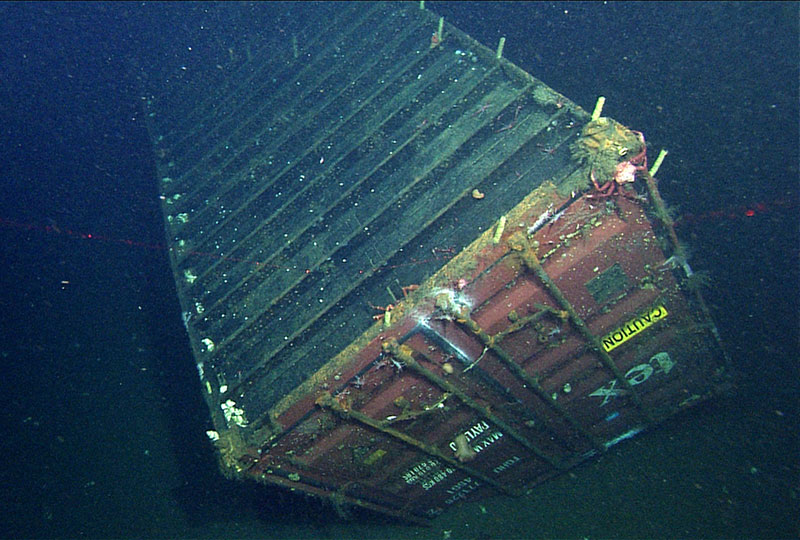
Another concern for habitat quality is the accumulation of marine debris in deep-sea habitats. Marine debris on the seafloor can impact both physical habitat and community composition, but impacts appear to be localized. In 2011, researchers measured the impacts of a shipping container that was lost at sea in early 2004 and came to rest on a sediment-covered seabed at a depth of 1,281 meters in MBNMS (Taylor et al. 2014). They found higher sediment grain-size near the container, which is very likely related to the hydrodynamic effects of the container on local flow patterns leading to net removal of fine sediments. These changes in sediments may be the cause of a drop in diversity and richness of the benthic infaunal community near the container site. Additionally, the surface of the container provides hard substrate for colonization by taxa usually found in association with rocky habitat, not sediment-covered seabed (Figure 40). Conversely, some key taxa that dominate rocky habitat at this depth were absent or rare on the container, perhaps related to potential toxicity of the paint or limited time for colonization and growth. Overall, results indicate that the container has conferred a mild disturbance in a 10 meter halo around the 30 square meter container (an area of 600 square meters), which has led to increased abundance for some species and lower abundance for others. Future study of the container and other debris on the seafloor is needed to determine the cumulative impact of debris on habitat quality and whether debris is a significant source of contaminants to sediments or local fauna.
6. What is the condition of biologically-structured habitats and how is it changing?
In 2009, the condition of offshore, biologically-structured habitats, including soft-corals, gorgonians, sponges and brachiopods was rated as “fair/poor” based on the known negative impacts of bottom-contact fishing gear on biologically-structured habitats and the extensive use of these gears in the offshore environment in the past where these sensitive resources were likely to occur. As of 2009, there was very limited study of structure-forming species and the impact of trawling and other human activities had not been assessed broadly. The 2015 status rating remains “fair/poor” because new information provides mostly initial characterization of previously unexplored locations and there has been little repeated observation of sites to assess temporal changes in the status of biologically-structured habitats.
In 2009, the trend was “undetermined” because it was unclear if resources had begun to recover in the portions of the sanctuary that had been recently closed to trawling. The trend in 2015 remains “undetermined” because there has been little additional information on the status of structure-forming species that may be improving in the areas closed to trawl gear. Certainly, the condition of structure-forming species may be improving in the sanctuary because bottom trawling effort has declined, moved to areas with less sensitive habitat and switched to less destructive gear. Nonetheless, there are emerging concerns in regards to ocean acidification and the declining condition of corals and other species with calcified body parts. We need more information on both the recovery from trawling and impacts of ocean acidification to better assess these questions.
Information on the distribution and condition of these organisms is limited, especially in more remote areas and in comparison to historic abundance and distribution patterns. The existing data was augmented by recent towed camera sled and ROV video surveys in limited areas of the outer shelf, upper slope, submarine canyons and at Sur Ridge. For example, the sanctuary, in collaboration with MBARI, was able to explore Sur Ridge for the first time in 2013, and again in 2014. The first views of this large submerged rocky ridge revealed areas covered in extensive beds of deep-sea corals and sponges (Figure 41) and the unexpected discovery, on the south side, of some chemosynthetic biological communities.

Structure-forming species generally grow slow and are patchily distributed organisms sensitive to human activities that contact the seafloor. Lindholm et al. (2008) studied patterns in the distribution of the sea whip in an area off the central California coast impacted by mobile fishing gear. Lindholm et al. found that the marked difference in the occurrence of upright sea whips among video transects may be attributable to water depth and/or impacts from otter trawling. In a recent study of trawling impacts and recovery of soft bottom habitat at a depth of approximately 170 meters off central California (Morro Bay area), Lindholm et al. (2015) found little to no detectable impact of trawling on the physical topography and biological community, except for persistent scour marks from trawling gear. In addition, the invertebrate assemblage in the study area was found to be highly variable in both space and time, suggesting that aspects of this habitat can be dynamic, making it difficult to understand and predict the impacts of trawling on the benthic community. These, and additional recent publications on the impacts of bottom trawling on soft bottom habitat, have noted that little has been written about recovery of seafloor habitat from the effects of fishing, and that there is a lack of long-term studies to fully evaluate impacts.
Given that fisheries management actions now prohibit trawling in some previously trawled areas (e.g., Trawl Rockfish Conservation Areas, Essential Fish Habitat closures, California state waters), it is likely that structure-forming invertebrates have been recovering and recolonizing these areas. In addition, structure-forming species are likely receiving less impacts now that fishing effort with bottom trawl gear has declined overall in the sanctuary and the gear being used (i.e., small-footrope trawl gear) is less damaging to benthic resources. Bottom trawling also appears to have shifted to less sensitive habitat types and locations (see Offshore Question 8 for additional detail). Though it is likely that some recovery has and will continue to occur, these biologically-structured habitats may recover slowly or may never re-establish to their original abundance or composition, even in the absence of future pressures.
The addition of hard structure to the seafloor, such as unburied submerged cables or marine debris composed of plastic, metal and glass, is a disturbance to the physical habitat and local abundance and distribution of benthic invertebrates. Recent studies of a lost shipping container (see Figure 40) and the unburied section of a submerged cable found an increase over time of the number of structure-forming species that require physical structure for attachment, such as crinoids and anemones, on and immediately adjacent to the structures (Kuhnz et al. 2011, Taylor et al. 2014).
One topic of increasing concern is the potential impacts of changing ocean conditions on biogenic species, many of which have calcified structures. We are not aware of specific studies of impacts of acidification on biogenic species in the sanctuary, but a recent meta-analysis shows that acidification has a strong negative effect on calcification rates and abundance of corals (Kroeker et al. 2013). Directed study of the effects of climate driven changes in pH, temperature and dissolved oxygen on structure-forming species will become increasingly important for understanding and tracking the status and condition of the sanctuary’s structure-forming species in the future.
7. What are the contaminant concentrations in sanctuary habitats and how are they changing?
Based on elevated levels of pesticides in shelf and canyon sediments at sites off the shore of urban and agricultural pollution sources, the condition of offshore habitats was rated as “good/fair” in the 2009 report. The basis for this judgment was that trends in contaminant concentrations in offshore habitats had not been well studied. There was, however, limited research to suggest little to no attenuation in the concentration of some persistent contaminants in sediments on the continental shelf and continued inputs and delivery of some contaminants to deep-sea habitats, such as submarine canyons (see 2009 MBNMS Condition Report for specifics). This limited information suggested an overall “declining” trend for this question.
There is no new information on contaminants in sediments, but given the rationale from the 2009 rating, there is no reason to believe that there has been a substantial decrease in the contaminant levels in sediments. New information does suggest that PCBs may be an even bigger problem than previously realized given new data that indicates an exponential increase in the amount of PCBs measured in the water column at two CCLEAN monitoring sites. For this reason, the new rating has been changed to “fair” with the same “declining” trend as in 2009.
In 2012-2013, the analysis of PCBs in water and wastewater treatment plant effluent was expanded from 70 congeners historically measured by CCLEAN to all 209 PCB congeners in order to better determine the source of the elevated PCBs. Measurement of all 209 congeners resulted in 60-70% higher total PCB concentrations compared to the 70 previously measured. This new information indicates that the historical total PCB concentrations could have been substantially higher. The Monterey Bay results were then compared to a site monitored just outside of San Francisco Bay by the Regional Monitoring Program (RMP), and the results were similar; however, the highest Monterey Bay results exceeded those at the Golden Gate (CCLEAN 2014, Figure 42). Even though total concentrations of PCBs were similar at the two sites, results for all 209 congeners were very different. There were much higher percentages of low-chlorine homologs in the Monterey Bay samples compared to the Golden Gate samples. Monterey Bay congeners were also more consistent than what was measured at the Golden Gate site, which were highly variable. This suggests different sources of PCBs at the two sites (CCLEAN 2014).

Several studies were reviewed to determine if there was a connection between PCBs found in sanctuary waters with PCB contamination in killer whales (Orcinus orca) and the marine mammals on which they feed. Ross et al. (2000a) divided the eastern North Pacific killer whales into three populations: (1.) northern resident, (2.) southern resident and (3.) transient. Whales seen on the central coast that primarily consume other marine mammals are generally from the transient population. The total PCB concentrations were surprisingly high in all three populations, but especially high in the transients. Even with the contrasting diets of the resident and transient killer whales, the mean congener-specific PCB profiles were similar among the three populations. The profiles were dominated by higher chlorinated congeners, with most of the lower congeners being absent or present at very low levels. The role of age, sex and dietary preference is strongly related to contaminant accumulation, and it is unclear how and if the lower PCBs congeners are metabolized or are absent. Adult females showed lower PCB concentrations during reproductive years beginning at 15 years old and showed increases again at 50 years old. Females transfer approximately 60% of organochlorines to their offspring through reproduction and lactation (Ross et al. 2000a).
After better understanding the PCB signature in transient killer whales, an attempt was made to research the PCB signature in their food and its effects. Persistent organic pollutants (POPs) are found in lipid rich blubber layers of marine mammals around the world (O’Shea 1999). PCB levels have been associated with a high prevalence of cancer in California sea lions (Zalophus californianus), including immunotoxic and reproductive impacts (Ross et al. 2000b, Ylitalo et al. 2005). In a study by Hall et al. (2008), they measured changes in blubber contaminant concentrations in California sea lions associated with weight loss and weight gain during
rehabilitation. They found that total DDTs dominated the contaminant profiles, followed by total PCBs and total PBDEs. During mass loss, the lower chlorinated PCB congeners, chlordanes and hexachlorocyclohexanes were lost at a higher rate than the other contaminant classes, such as PBDEs. The preferential mobilization of the lesser chlorinated PCBs has also been reported in gray seals (Halichoerus grypus) during lactation fasting (Debier et al. 2003) and in gray and Northern elephant seals (Mirounga angustirostris) during post-weaning fast (Debier et al. 2006).
Because of the different PCB profiles between water and sediment samples, as well as natural degradation and physiological processes, it is difficult to make a direct connection between sources of PCBs and their uptake and effects on marine organisms. A Stream Pollution Trends (SPoT) program report measured PCBs and found low concentrations and no acute invertebrate toxicity due to PCBs in sediments from central coast watersheds (Phillips et al. 2014). The negative effects occur as the PCBs begin to bioaccumulate in the food web, as demonstrated above. While concentrations in fish do not often exceed thresholds of concern (Davis et al. 2012), numerous fish consumption advisories have been issued for lakes, rivers, bays and coastal areas within California due to these contaminants. While we cannot make a definitive link between PCBs coming off the land, measured in sanctuary waters and sediment, and found in killer whale tissues, we can state that: (1.) PCBs are elevated in the offshore waters of Monterey Bay; (2.) PCBs are elevated in marine mammal tissues; (3.) the congener profiles are different in water and mammal tissues, with lesser chlorinated congeners in water and more highly chlorinated congeners in mammals; (4.) lower chlorinated congeners appear to be excreted or metabolized in smaller mammals preyed upon by killer whales; and (5.) marine mammals in Monterey Bay are highly contaminated by persistent organic pollutants, including PCBs.
8. What are the levels of human activities that may influence habitat quality and how are they changing?
In 2009, the level of human activities that influence habitat quality in the offshore environment was rated as “fair/poor” primarily because bottom-contact fishing gear had been employed widely for many decades, and additionally because marine debris accumulated for decades in offshore habitats. The 2015 status rating is changed to “fair” based on decreases in both overall effort and spatial extent of fishing with bottom trawl gear as compared to the past when it was more widespread and occurred in areas with more sensitive habitats.
In addition, new studies indicate that impacts of bottom trawling gear, submerged cables and marine debris on soft bottom habitats are localized. The trend in 2009 was “improving” because the level of fishing with bottom contact fishing gear had been reduced by landing restrictions, gear restrictions and area closures. The trend in 2015 remains “improving” because bottom trawling, which is the most damaging human activity in the offshore environment, has decreased in spatial distribution and intensity, especially in areas with the most sensitive resources. Inputs of marine debris and contaminants continues, but it is unclear if there has been an increase in the rate of these activities.
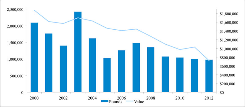
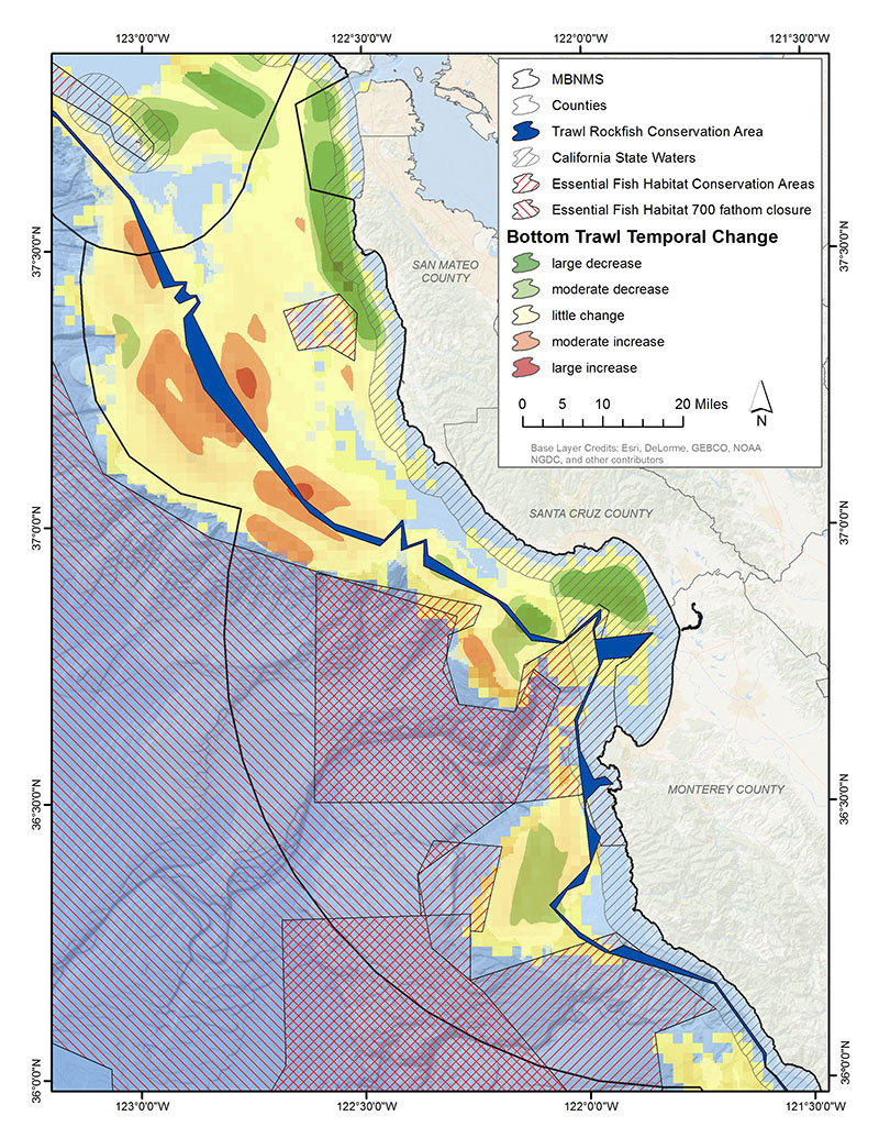
Overall trawling effort, as evidenced by catch records from bottom trawl fishing inside the sanctuary, appears to be much lower recently, as compared to the higher levels that occurred from 2000-2003 and appears to have stabilized between 2009-2012 at around 1 million pounds (Figure 43) (Leeworthy et al. 2014). These decreases in the overall bottom trawl fishing effort are likely due in part to changes in fisheries management. In the 2009 condition report, there were concerns that area closures might lead to redistribution of fishing effort and increased fishing pressure in areas open to bottom trawl fishing. New information on the general distribution of change in fishing effort using bottom trawl gear along the U.S. West Coast before (2002-mid-2006) and after (mid-2006-2010) implementation of essential fish habitat area closures shows that effort has been redistributed inside the sanctuary (Figure 44) (NMFS 2013a, b). Decreases in effort occurred mostly in or adjacent to state waters off the San Mateo county coast and in northern Monterey Bay, and the outer shelf off Point Sur. The majority of large or moderate increases in effort occurred in soft-bottom habitat on the outer shelf and upper slope flanking the Trawl Rockfish Conservation Area in the northern half of MBNMS.
In 2011, the National Marine Fisheries Service and the Pacific Fisheries Management Council implemented an individual fishing quota (IFQ) program in the federal Pacific coast groundfish fishery. Some goals of IFQ management include decreased bycatch and increased catch accountability, profitability and efficiency. Somers et al. (2015) summarized changes in distribution and intensity of bottom trawl effort along the U.S. West Coast since the implementation of the IFQ program. Broadly, it appears that the patterns shown in Figure 44 have continued with IFQ management (K. Somer, NMFS-NWFSC, pers. comm.). However, since most of the log book data on bottom trawl effort in MBNMS from the program’s implementation is not publically available due to confidentiality limitations, a more detailed description of recent patterns in trawling effort was not possible at this time.
A recent study off central California of impacts to benthic habitat and living resources from high and low intensity trawling with small footrope gear found that, although there were some detectable impacts to seafloor sediment structure, changes in associated infauna, epifauna and structure-forming species were difficult to detect (Lindholm et al. 2015). The invertebrate assemblage in the study area was found to be highly variable in both space and time, suggesting that aspects of this habitat can be dynamic, making it difficult to understand and predict the impacts of trawling on the benthic community. Impacts of trawling appear to be specific to the time and location of the activity. The magnitude and duration of any impacts will likely be dependent on the faunal community and the physical and ecological processes that occur at the site at the time of impact.
Three other concerns about negative impacts of human activities on the quality of offshore benthic habitats are installation of submerged cables, accumulation of contaminants and marine debris (e.g., trash, lost fishing gear) on the seafloor. Studies of submerged cables in the sanctuary have shown little measurable impacts of the cable on physical habitat after the initial installation phase is complete, and some increases in local abundance of structure-forming invertebrates, such as anemones and crinoids, that use exposed segments of the cable as hard substrate for attachment (Kogan et al. 2006, Kuhnz et al. 2011). Contaminants in offshore habitats are still a concern, as we discussed in the 2009 MBNMS Condition Report (ONMS 2009). The limited new information on contaminants in habitats, with a focus on increasing PCB levels in the sanctuary’s offshore waters, and possible impacts to living resources is discussed in Offshore Question 7.
Recent studies of marine debris in offshore habitats have found that marine debris can be surprisingly abundant on portions of the sanctuary’s deep seafloor. Schlining et al. (2013) reviewed patterns in marine debris observed using 22 years of video footage from Monterey Bay covering depths from 25-3,971 meters. The majority of debris was plastic (33%) and metal (23%) and debris was relatively more abundant within Monterey Canyon; this result suggests that submarine canyons act as conduits for debris transport from coastal to deep-sea habitats (Figure 45). This study, as well as two others of marine debris in shallower (15-450 meters) (Aiken et al. 2014) and deeper (1,281 meters) (Taylor et al. 2014) habitats, suggest that impacts of marine debris on habitats and associated animals communities are fairly localized and may be negative for some faunal groups (e.g., some soft-bottom associated infauna and epifauna) and positive for others (increased abundance of fish and invertebrate taxa found in association with rocky habitat and structure-forming species).
There are some efforts to reduce inputs of debris into the sanctuary through litter clean-ups on beaches and in watersheds (see Nearshore Question 8 for more detailed information). In addition, over three years (2009-2011), MBNMS staff and partners removed more than 1,000 pounds of lost fishing gear from the offshore habitats in the sanctuary that posed hazards to benthic and pelagic marine organisms (De Beukelaer and Grimmer 2014).
Offshore Environment Habitat Status and Trends
Status: Good Good/Fair Fair Fair/Poor Poor Undet.
Trends:
▲ Conditions appear to be improving.
- Conditions do not appear to be changing.
▼ Conditions appear to be declining.
? Undeterminted trend.
N/A Question not applicable.
| # | Issue | Rating | Confidence | Basis For Judgement | Description of Findings |
|---|---|---|---|---|---|
| 5. | Abundance/ Distribution |
Status: High Trend: Medium |
Benthic habitat loss and modification due to fishing with bottom-contact gear; recovery of seafloor habitats likely occurring in some locations following reductions in this activity. | Selected habitat loss or alteration may inhibit the development of assemblages, and may cause measurable, but not severe declines in living resources or water quality. | |
| 6. | Biologically- Structured |
Status: High Trend: Medium |
Damage to and loss of structure-forming and structure-building taxa due to trawl fishing. Recovery likely occurring in some locations and for some taxa following reductions in this activity; however concerns that ocean acidification is negatively impacting these species. | Selected habitat loss or alteration has caused or is likely to cause severe declines in some, but not all living resources or water quality. | |
| 7. | Contaminants | Status: High Trend: High |
Exponential increase in amount of PCBs in water samples from two sites. Marine mammals are contaminated by PCBs. No evidence of strong ecosystem level effects. No additional information on contaminant levels in ocean sediments. | Selected contaminants may inhibit the development of assemblages and may cause measurable, but not severe declines of living resources or water quality. | |
| 8. | Human Impacts | Status: High Trend: High |
Decreases in both overall effort and spatial extent of fishing with bottom trawl gear. Inputs of marine debris and contaminants continues. Impacts of submerged cables and marine debris appear to be localized. | Selected activities have resulted in measurable habitat impacts, but evidence suggests effects are localized, not widespread. |
The questions with red numbers have new ratings compared to the 2009 Monterey Bay National Marine Sanctuary Condition Report (ONMS 2009).
Offshore Environment: Living Resources
Biodiversity is variation of life at all levels of biological organization, and commonly encompasses diversity within a species (genetic diversity) and among species (species diversity), and comparative diversity among ecosystems (ecosystem diversity). Biodiversity can be measured in many ways. The simplest measure is to count the number of species found in a certain area at a specified time; this is termed species richness. Other indices of biodiversity couple species richness with a relative abundance to provide a measure of evenness and heterogeneity. When discussing biodiversity, we primarily refer species richness and to diversity indices that include relative abundance of different species and taxonomic groups. To our knowledge, no species have become extinct within the sanctuary; therefore, native species richness remains unchanged since sanctuary designation in 1992. Researchers have described previously unknown species (i.e., new to science) in deeper waters, but these species existed within the sanctuary prior to their discovery. We do not include non-indigenous species in our estimates of native biodiversity; the status of non-indigenous species in the sanctuary is addressed in question 11.
Key species, such as keystone species, indicators species, sensitive species and those targeted for special protection, are discussed in the responses to questions 12 and 13. Status of key species will be addressed in question 12 and refers primarily to population numbers. Condition or health of key species will be addressed in question 13. The sanctuary’s key species are numerous and cannot all be covered here. Instead, in this report, we emphasize various examples from the sanctuary’s primary habitats that have data available on status and/or condition.
The following information provides an assessment of the current status and trends of the sanctuary’s living resources in the offshore environment.
9. What is the status of biodiversity and how is it changing?
Thorough historic and current inventories are not available to fully measure biodiversity status and trends in the sanctuary. Based on the best available information, the status of native biodiversity in the sanctuary’s offshore habitats was rated “fair” in the 2009 MBNMS Condition Report because, although native species richness remained unchanged, the relative abundance of many species and taxonomic groups had been substantially altered by both natural and anthropogenic pressures. Shifts in the relative abundance of multiple species, especially those at higher trophic levels, are indicators of compromised native biodiversity in the system and impact community and ecosystem structure and function. However, the cumulative trend in biodiversity was “undetermined” due to a lack of information on the changes in relative abundance of many deep-sea species, and uncertainty about how to combine the individual trends in species abundance into a cumulative trend in biodiversity.
Recent trends in abundance are available for a number of key species and is summarized in more detail in Offshore Question 12. Additionally, some new information on biodiversity of pelagic forage and soft-bottom infaunal groups will be discussed below. Based on said information, the 2015 status of biodiversity will remain “fair,” with a trend of “not changing” because, though some species and faunal groups have increased or decreased in abundance since 2009, there is not strong evidence that overall biodiversity in the offshore environment has increased or decreased significantly during this time. Many of the species and faunal groups, for which we have time series data, appear to have fluctuated within the range that is expected, based on a longer time series.
A historical perspective suggests that many of the offshore environment’s higher trophic level species, such as marine mammals, seabirds and predatory fishes, are at reduced abundances. The most recent stock assessments by the National Marine Fisheries Service finds that most mammal stocks in the sanctuary are stable or slowly increasing in abundance (Carretta et al. 2013). Some locally breeding seabirds have experienced average (e.g., common murre) to above average (e.g., Cassin’s auklet) reproductive success in recent years, while reproductive success of others (e.g., Brandt’s cormorant) has been below average (see Offshore Question 12 for more detailed information). Levin et al. (2006) found that decades of fishery extraction contributed to changes in the fish assemblage on the continental shelf and slope. Specifically, the species that dominated the shelf/slope assemblage had vastly different trophic roles and life-history strategies than the species they replaced. Though recent changes in fishery management have improved stock status for overfished species (NMFS-CCIEA 2014), it is unclear if the relative abundance of functional groups has started to change back to the conditions observed many decades ago.
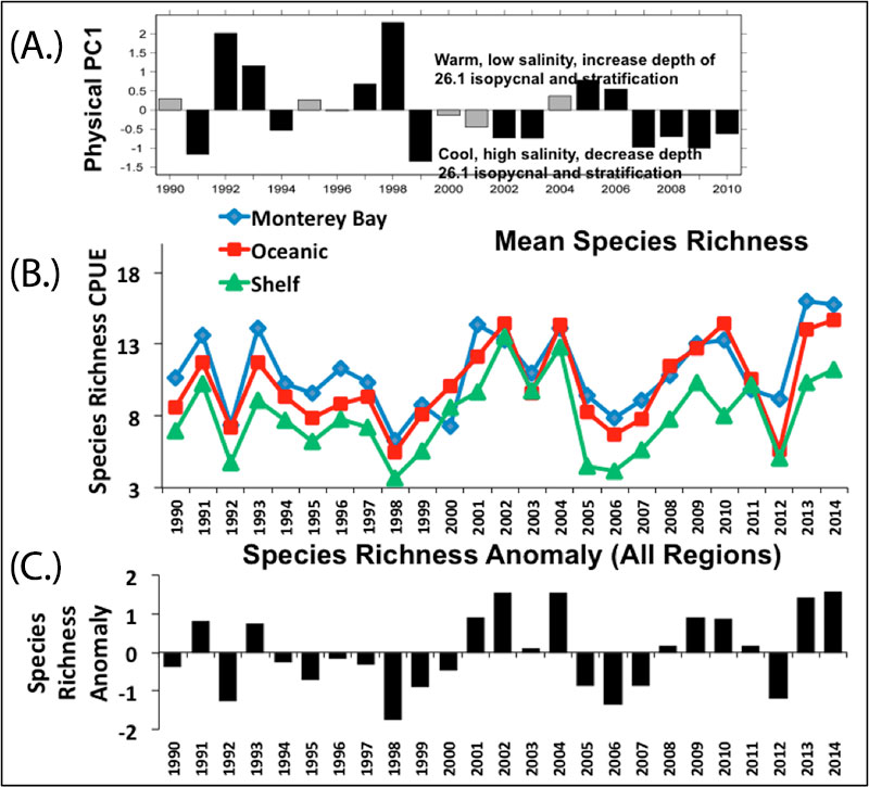
A newly derived index of species richness of the epipelagic forage community, based on the presence of 68 taxa collected in mid-water trawl nets by the National Marine Fishery Service Southwest Fisheries Science Center’s (NMFS-SWFSC) Rockfish Recruitment and Ecosystem Assessment Surveys, can be used to explore spatio-temporal patterns of diversity over the last 25 years and regional ocean conditions (Figure 46a) (Santora et al. 2014, J. Santora, 2011-2014 unpubl. data). The midwater trawl samples used to create this index have been collected each May and June since 1990, and include fixed sampling stations over the shelf and out to the 2,000 meter isobath between the Monterey peninsula and the Gulf of the Farallones (Santora et al. 2012). Interannual variability of species richness largely reflects production of juvenile rockfish (Sebastes spp.). Observed species richness of the epipelagic forage community is slightly higher in samples collected from the Monterey Bay and oceanic regions (offshore sites) as compared to the shelf region (Figure 46b). In addition, species richness was lower during warm water conditions and higher during cool water conditions; this pattern is coherent among all three ecological regions (shelf, oceanic and Monterey Bay). Relatively high forage species richness was observed from 2009-2014, a period with generally cool and productive conditions (Figure 46c).
The abundance of jumbo squid (Dosidicus gigas) observed during MBARI’s midwater ROV surveys in Monterey Bay has increased recently in the sanctuary (Panel D in Figure 37), which may impact both regional and local biodiversity. This species may affect local biodiversity by driving changes in the pelagic food web because jumbo squid is both: (1.) a voracious predator of a variety of pelagic and semi-pelagic fishes (e.g., Pacific hake, Pacific herring, northern anchovy, sablefish, salmonids, various rockfishes, myctophid fishes, squids) (Field et al. 2007, Field et al. 2013) and (2.) an important forage item for many higher trophic level fishes and marine mammals, including toothed whales and tunas, billfishes and sharks (Field 2008). These animals are likely to play a major role in the structure of offshore ecosystems. The cause of the observed range expansion of jumbo squid has not been determined; possible contributing factors include the recent cool phase of the Pacific Decadal Oscillation, harvest of large pelagic predators and shoaling of the OMZ due to global climate change (Stewart et al. 2014).
Biodiversity in the sanctuary’s deep-sea communities is not well understood because of the logistical challenges of conducting research in deep water. A recent study compared patterns of biodiversity of infaunal communities in sediments collected from various locations on the sanctuary’s shelf and slope (Oliver et al. 2011). This study found 1,521 species of macrofaunal invertebrates in 32 square meters of bottom sampled, which is one of the highest species densities reported from soft-bottom habitats worldwide. Samples from the shelf (30-150 meters) had higher species density, larger number of animals and greater evenness of relative abundance compared to samples from the slope (250-2000 meters), which suggests that the complexity of biological interactions may be higher on the shelf than on the slope (Oliver et al. 2011). The highest number of species was observed at the shelf-slope break (100-150 meters) coincident with the location of breaking internal waves in the Monterey Bay and under an upwelling plume and production hot spot. Future repeated samplings of these or similar locations would be useful to track patterns in the diversity of infaunal communities over time.
There are indications that deep-sea sponge and coral communities in the sanctuary have been impacted by human activities before many aspects of their basic biology and ecology could be ascertained (J. Barry, MBARI, pers. comm.). There is little repeated monitoring of these benthic resources to track changes in condition and potential recovery from these past impacts. Overall, there is much to be learned about the species richness and evenness of several important communities within the sanctuary’s offshore habitats.
10. What is the status of environmentally sustainable fishing and how is it changing?
We no longer assess this question in ONMS condition reports; therefore, content for this question was not updated.
11. What is the status of non-indigenous species and how is it changing?
In 2009, the status of non-indigenous species in offshore habitats was rated “good” and “not changing” because very few non-indigenous species had been identified in offshore habitats and those present did not appear to affect ecosystem integrity (ONMS 2009). In 2015, the rating remains “good” and “not changing” because we are not aware of substantial new information on the status of non-indigenous species in MBNMS’s offshore habitats.
12. What is the status of key species and how is it changing?
In 2009, the status of key species in the offshore environment was rated “good/fair” and the trend was “not changing” based on the known population sizes of many high-profile species in the offshore environment, including marine mammals, seabirds, pelagic fishes (e.g., salmon, tunas, sharks) and sea turtles. Many of these are apex predators and play important ecological roles in the sanctuary ecosystem. On-going monitoring of many of these species, along with new data on a few other key components of the offshore ecosystem, reveal that population sizes are changing, but mostly within the range that is expected based on long-term time series. Therefore, the 2015 rating for key species remains “good/fair” and “not changing.”
Below we briefly provide updated information on the status of a number of key species that play important ecological roles in the sanctuary ecosystem as either predators or the forage base for the pelagic system.
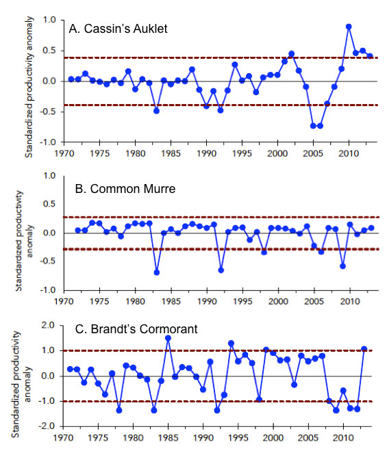
Based on the latest stock assessments by the National Marine Fisheries Service, most marine mammals (e.g., whales, dolphins, seals, sea lions) that are residents or seasonal visitors to MBNMS are stable or increasing in abundance at the population level (Carretta et al. 2013). The local abundance of mammal species that migrate to the sanctuary to forage (e.g., humpback, blue and fin whales) is strongly influenced by the abundance and distribution of their prey, such as krill, sardine and anchovy. Breeding success of locally breeding seabirds has varied recently by species. For instance, Cassin’s auklet has had higher than average breeding success, common murre breeding success has fluctuated around the long-term mean and Brandt’s cormorant breeding success was very low until a very successful year in 2013 (Figure 47) (Warzybok et al. 2013, Elliott and Jahncke 2014).
Salmon and groundfish are key species in the sanctuary due to their important role in both the offshore food web and in commercial and recreational fisheries. Many of central California’s salmon stocks have been listed under the federal Endangered Species Act. As of 2013, the abundance of coho and Chinook salmon stocks that use MBNMS’s offshore environment are at reduced abundance levels and many show declining trends (Wells et al. 2014a). Based on recent stock assessments by the National Marine Fisheries Service and Pacific Fisheries Management Council, the status of groundfishes (e.g., rockfishes, flatfishes) has improved compared to 2009. As of 2013, three assessed stocks (canary rockfish, yelloweye rockfish, Pacific Ocean perch) are in an overfished state, but increasing in abundance (as compared to seven stocks in an overfished condition in 2009), and there is no recent indication of overfishing on any assessed groundfish stocks, which suggests increasing relative abundance of groundfish in the offshore environment (Cope and Haltuch 2014).
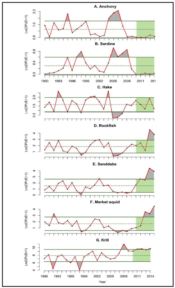
Forage species directly and indirectly support the tremendous abundances and species diversity of higher trophic levels. The annual abundance of seven key forage groups has been monitored each year (May-June) off central California since 1990 by the NMFS-SWFSC Rockfish Recruitment and Ecosystem Assessment Surveys (Figure 48) (Wells et al. 2014b). Notably, 2013 and 2014 had some of the highest densities of young-of-the-year (YOY) rockfish, sanddab and market squid ever observed by this survey. Krill abundance has been high and unusually stable since 2009, and Pacific sardine and northern anchovy abundance has been low over the same period. Years with high numbers of YOY groundfish, market squid and krill are generally associated with cooler ocean conditions and high levels of upwelling and productivity, which in turn are associated with greater breeding success and productivity of many of the higher trophic level predators that forage on this assemblage, such as seabirds and salmon (Santora et al. 2012, Wells et al. 2012). The lower abundance of anchovy and sardine in such years may reflect localized availability (these stocks may be distributed further south and/or offshore during high upwelling conditions in the period this survey operates) (Wells et al. 2014b).
13. What is the condition or health of key species and how is it changing?
The condition of key species in the offshore environment will continue to be rated “good/fair” and “declining” (ONMS 2009). The available new information, though limited, is consistent with the 2009 assessment that the health of several key species is impacted by exposure to neurotoxins produced by harmful algal blooms (HABs), entanglement in active and lost fishing gear, ingestion of marine debris and accumulation of persistent contaminants. The continued input of non-biodegradable marine debris and persistent contaminants into the offshore waters of the sanctuary, combined with the lack of attenuation of legacy contaminants, suggests that these threats to the condition of key species may have slowly increased over the past decades and are likely to continue to slowly increase in the future. Though the threats posed by persistent contaminants, HABs and marine debris (NRC 2008) are fairly pervasive in the world’s ocean, highlighting these issues in MBNMS, and providing an update of available data, can help to inform future research and management efforts to reduce these impacts to key species in the sanctuary.
Below we will briefly summarize some new information on health impacts to key species, except for health impacts from contaminants, which is summarized in the response to Offshore Question 7, and increases in frequency of harmful algal blooms, which is summarized in the response to Nearshore Questions 2.
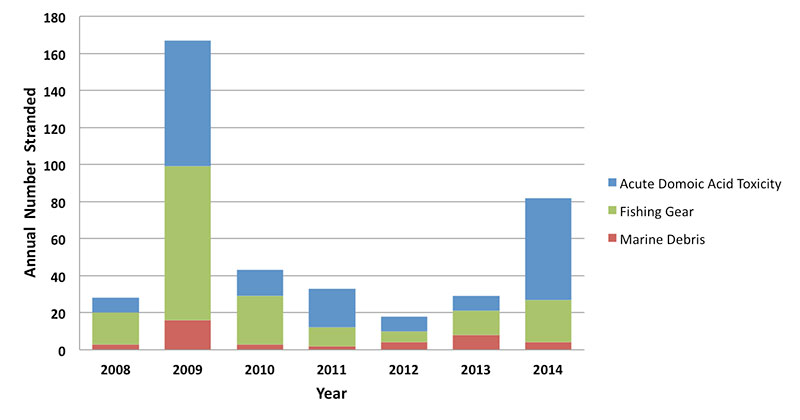
The Marine Mammals Center (MMC), a rehabilitation center on the central California coast, tracks the cause of strandings of marine mammals including animals stranding on MBNMS’s beaches. Domoic acid, a neurotoxin produced by the diatom Pseudo-nitzschia, continues to impact the health of key species. The annual number of marine mammals that stranded on sanctuary beaches from 2008-2014 and were determined to have died from acute domoic acid toxicity ranged from a low of eight (in years 2008, 2012 and2013) to highs of 55 (2014) and 68 (2009) animals (blue bars in Figure 49) (MMC, unpubl. data). Each year marine mammals, mostly seals and sea lions, strand on beaches in the sanctuary due to interaction with active and lost fishing gear (e.g., fishing nets, crab pots, fishing hooks, monofilament line) or entanglement in other man-made debris (e.g., packing straps, plastic bags, rope) (Figure 49) (MMC, unpubl. data).
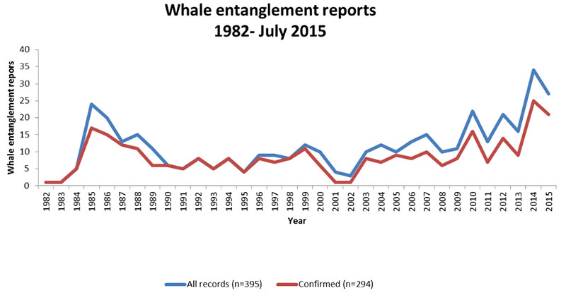
Currently, reports of large whale entanglement (primarily humpback whales and gray whales) in active or lost fishing gear and other man-made lines (e.g., buoy lines) is on the rise in California, including Monterey Bay. For the period from 2014 to July 2015, there were 46 large whale entanglements confirmed along the U.S. West Coast, with 35 of those in California (14 of which were in Monterey County). In comparison, for the entire West Coast from 1990 to 2009, about 10 whale entanglements were reported each year (Figure 50). The cause of the recent spike in reports of entangled whales is not clear. Potential contributing factors include increasing whale populations, increasing overlap of whale activities (e.g., migrating, feeding) with human activities that have the potential to entangle whales (e.g., fishing, buoy installation) and an increase in on-the-water observers likely to report entangled animals (e.g., whale watching, recreational boating). Whales that migrate or feed close to shore enter a region prone to having more gear in the water. Humpback whales have been feeding close to shore in the Monterey Bay region in recent years, which may be contributing to an increase in whale-gear interactions. Another contributing component is that of the fishing industry itself, which for certain sectors has seen an increase of landings taken from central California (largely Monterey County). This potential combination of more effort nearshore by both whales and humans may be a leading factor in the recent increase of entanglement events.
Marine mammals being injured or killed by boat strikes is an additional health concern for large whales, smaller cetaceans and pinnipeds. Each year, a couple of marine mammals are found stranded on sanctuary beaches with obvious signs of interactions with boats (MMC, unpubl. data; MBNMS, unpubl. data). Between July and October 2010, two blue whales (one pregnant female that resulted in the loss of the fetus), one humpback and two fin whales were found dead in and around Monterey Bay, Greater Farallones and Cordell Bank national marine sanctuaries. Nonetheless, the exact number of marine mammals that are injured or killed each year from interactions with boats is very difficult to determine because many of these animals are unlikely to strand on beaches where they can be found, and it is hard to ascertain the specific cause of death (through necropsy) and link mortality to vessel strikes.
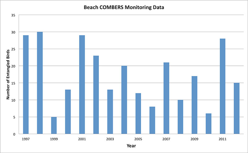
Entanglement in marine debris is also a health concern for seabirds. The sanctuary’s Beach COMBERS monitoring program has documented seabird carcasses found on area beaches that are entangled in marine debris for the years 1997-2012 (Figure 51). Over the 15 year study period, a total of 279 entanglements were reported by surveyors affecting 24 seabird species (Nevins et al. 2014). The five species that comprised the highest percentage of entanglements were common murres (23%), sooty shearwaters (12.5%), Brandt’s cormorants (10%), western gulls (9%) and brown pelicans (7%). Alcids (24%), gulls (21.5%) and cormorants (15%) were the seabird groups most commonly affected. Monofilament fishing line was the dominant source of entanglement, and a hook or lure was often present on these lines. There were seven reports of net interactions (herring, gill and fishing nets). Three reports mentioned entanglement via a balloon string around the legs and/or wings, and two reports cited the ingestion of a balloon piece in the stomachs of a common murre and a fulmar.
Recent large stranding events of Cassin’s auklets and California sea lions appear to be the result of the starvation of juvenile animals due to low prey availability and unusual oceanographic conditions. Beached-bird surveys recorded unusually high numbers of dead Cassin’s auklets (Ptychoramphus aleuticus) on beaches from British Columbia through central California (Henkel et al. 2015). In central California, encounter rate peaked in November and December 2014, based on Beach COMBERS monitoring data. Most of the birds from central California were hatch-year birds with emaciated or poor body condition, and presumed to have died of starvation. A likely contributing cause of this mortality event is the unusually large cohort of hatch-year auklets that were apparently unable to find adequate prey resources to survive their first winter (Henkel et al. 2015). Prey shortages were likely influenced by anomalous ocean conditions (described in response to Offshore Question 1). Prey shortages also appear to be the cause of poor growth rates of California sea lion (Zalophus californianus) pups observed by the NMFS monitoring program at San Miguel Island (Harvey et al. 2014) and the unusually large number of stranded, malnourished pups that have been admitted to rehabilitation centers in southern and central California in the winter and spring of 2015. Although these events have significant health impacts on animals in these populations, it is unknown if these mass stranding events will have any lasting impacts on the overall health of these populations.
14. What are the levels of human activities that may influence living resource quality and how are they changing?
A number of human activities, including fishing, inputs of marine debris and vessel traffic, influence the quality of living resources in the offshore portion of the sanctuary. The level of these human activities was rated “fair” in 2009 and will continue to be rated “fair” in 2015 because most of these activities have resulted in measurable impacts to living resource quality. An “improving” trend was provided in 2009 because recent changes in fisheries management were likely to result in the improved status of fished species and reduced impacts to habitat and non-target species. The 2015 trend has been changed to “not changing” because, although fished stocks and habitats continue to recover from overfishing and impacts from bottom contact fishing, marine debris and contaminants are accumulating in offshore habitats and ocean acidification is increasing.
Fishing is a human activity that influences sanctuary habitats and living resources in a number of ways beyond the removal of targeted biomass. A number of changes in fisheries management implemented prior to 2007, including gear restrictions, area closures and landing reductions, appear to have resulted in overall better management of fished stocks (as evidence by recent stock assessments), decreased impacts to biogenic habitat and non-targeted species (summarized in response to Offshore Question 8), and a lower overall level of fishing effort in central California compared the 1990s and early 2000s. In 2011, NOAA Fisheries implemented the West Coast Groundfish Trawl Catch Share Program. The new program transitioned the fleets from a single, fleet wide quota that encouraged competition to catch as many fish as possible until the allocation was met to a catch or quota system controlled by individuals or groups of fishermen. This new catch shares system has allowed two important groundfish stocks, canary rockfish and petrale sole, to rebuild to a sustainable level over the last five years, and others are in the process of rebuilding. Available data on recent commercial fishing activity, including fishing for groundfish, salmon, market squid and Dungeness crab, in the sanctuary suggest that overall fishing activity has been steady, with some fishing activities increasing and others decreasing likely in response to environmental conditions and regulations (OST and CDFW 2013, Leeworthy et al. 2014).
Marine debris impacts marine life in many ways, most notably through entanglement (as discussed in the response to Offshore Question 13) and ingestion of plastic fragments that can clog the digestive tract. Although negative impacts to living resources from ingestion of plastics has been demonstrated in MBNMS in the past (e.g., Northern Fulmars in Monterey Bay from 2003-2007 in Donnelly-Greenan et al. 2014), we are not aware of any new studies in the sanctuary and thus, cannot determine if the problem is increasing in severity. However, the fact that many types of debris, in particular plastic debris, do not degrade raises concern that this problem will increase in severity in the future. The ability for plastics to attract and transport contaminants has been documented (Arthur et al. 2009) and this is an area that could use further study to determine potential impacts to the sanctuary’s living resources.
While small-scale and acute impacts may be diminished due to the large size of the offshore ecosystem, there are large-scale phenomena that continue to impact this system. Large vessels transiting through the sanctuary can negatively impact living resources in a number of ways including pollution, collision with animals, and noise. Two studies of ambient ocean noise levels along the California coast found that low-frequency background noise increased from the 1960s to the 2000s by about 3 decibels per decade at the two sites studied; Point Sur in MBNMS (Andrew et al. 2002) and San Nicolas Island in southern California (McDonald et al. 2008). Most of this increase in low-frequency ambient noise was attributed to an increase in shipping traffic during that time.
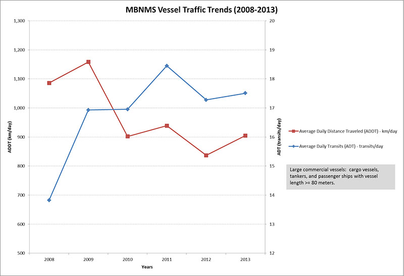
More recent measures of ambient low-frequency noise are not available inside MBNMS to determine if this increasing trend in vessel-generated noise has continued since the early 2000s; however, recent analysis of large vessel traffic inside and adjacent to MBNMS for the period 2008 to 2014 has found that there was an increase in the number of vessels transiting through MBNMS between 2008 and 2009, but no significant trend since 2009 (blue line in Figure 52). It is interesting to note that the overall distance traveled inside the sanctuary boundary decreased during this time because the vessels are transiting further to the west and spending less time overall in MBNMS (red line in Figure 52). This may mean an overall decrease in exposure of living resources inside MBNMS to some potential impacts from vessel traffic (e.g., collisions), but likely not a decrease in overall noise generated by this activity.
Large vessel traffic is one of a variety of human activities in and adjacent to MBNMS that generate underwater noise. Other potential sources of underwater noise in MBNMS include smaller recreational and commercial vessels, sonars used in military training, pile drivers and dredging used in marine construction, airguns and other seismic sources used in energy exploration, sonars and other active acoustic sources used in research activities, and aerial sources, such as overflights. Noise generated by these human activities can have a detrimental effect on a variety of marine animals including marine mammals, turtles, fish and invertebrates. Studies have documented behavioral responses, lost listening opportunities, and physical injuries in marine animals due to exposure to human-induced noise (NRC 2003, 2005). There is concern about the cumulative impacts of noise from a variety of sources on the natural “soundscape” of the sanctuary, and this is an active topic of research and management in MBNMS. Efforts to monitor the acoustic environment in MBNMS are underway and this data should help improve our understanding of potential impacts of human-induced noise on marine mammals and other wildlife in the sanctuary.
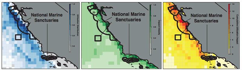
A recent study examined the spatial overlap of human activities with the distribution of large marine predators to find areas along the U.S. West Coast with a high likelihood of impacts. Maxwell et al. (2013) combined tracking data for eight species of marine predators (seabirds, whales, turtles) with data on 24 human stressors (weighted to reflect expected impacts specific to those predators) to calculate cumulative utilization and impact (CUI) scores for the entire U.S. West Coast. High CUI scores were used to identify locations where important species habitat and high-risk activities are likely to coincide. MBNMS had many cells with moderate to high CUI scores, especially for marine mammals and leatherback sea turtles. Cumulative impacts were higher inshore than offshore for all species groups, and the majority of the highest cumulative impact cells were found over the continental shelf which is consistent with most human stressors being concentrated near human population centers (Figure 53).
Global climate change's effects on ocean chemistry is an increasing stressor to offshore living resources. As was discussed in the response to Offshore Question 1, waters in MBNMS are becoming more acidic, which is a stressor on living resources, especially those with calcified body parts. Some impacts to living resources from increasingly acid waters have already been observed (e.g., Bednarsek et al. 2014). Ocean acidification from climate change has also been predicted to have implications for ocean acoustics by allowing low frequency sound to travel farther (Ilyina et al. 2010). More study is needed on the impacts of acidification on both pelagic and benthic organisms to better understand the level of current impacts and predict future impacts of changing water chemistry on the conditions of living resources. Global climate change is causing shifts in other physical properties of ocean waters, including increasing water temperature, hypoxia and shoaling of the Oxygen Minimum Zone, which are likely to have significant local impacts to living resource in the sanctuary’s offshore environment. Directed study of the effects of climate driven changes in pH, temperature and dissolved oxygen on a variety of species will become increasingly important to understand and track the status and condition of living resources in the sanctuary in the future.
Beach COMBERS
The Beach Coastal Ocean Mammal and Bird Education and Research Surveys (Beach COMBERS) Program uses trained volunteers to survey beached marine birds and mammals monthly at selected sections of beaches throughout Monterey Bay National Marine Sanctuary.
Offshore Environment Living Resources Status and Trends
Status: Good Good/Fair Fair Fair/Poor Poor Undet.
Trends:
▲ Conditions appear to be improving.
- Conditions do not appear to be changing.
▼ Conditions appear to be declining.
? Undeterminted trend.
N/A Question not applicable.
| # | Issue | Rating | Confidence | Basis For Judgement | Description of Findings |
|---|---|---|---|---|---|
| 9. | Biodiversity | 
|
Status: Medium Trend: Low |
Reduced relative abundance of targeted, by-catch, and sensitive species. Overall biodiversity does not appear to have increased or decreased during this time. | Selected biodiversity loss may inhibit full community development and function and may cause measurable, but not severe degradation of ecosystem integrity. |
| 11. | Non-Indigenous Species |
|
Status: N/A (not updated) Trend: N/A (not updated) |
Very few non-indigenous species identified in offshore waters. | Non-indigenous species are not suspected or do not appear to affect ecosystem integrity (full community development and function). |
| 12. | Key Species Status |
|
Status: Medium Trend: Low |
Some key species at reduced abundance levels due to past or on-going harvest. Some monitored key species slowly increasing, but most appear to be fluctuating within the range expected based on long-term time series | Selected key or keystone species are at reduced levels, perhaps precluding full community development and function, but substantial or persistent declines are not expected. |
| 13. | Key Species Condition | Status: Medium Trend: Low |
Compromised health due to exposure to neurotoxins produced by HABs, entanglement in active and lost fishing gear, ingestion of marine debris and accumulation of persistent contaminants. | The condition of selected key resources is not optimal, perhaps precluding full ecological function, but substantial or persistent declines are not expected. | |
| 14. | Human Activities |
|
Status: Medium Trend: Medium |
Recent management actions helping recover overfished stocks and impacted habitats, but inputs of marine debris and contaminants have measurable impacts; ocean acidification and hypoxia increasing. | Selected activities have resulted in measurable living resource impacts, but evidence suggests effects are localized, not widespread. |
The questions with red numbers have new ratings compared to the 2009 Monterey Bay National Marine Sanctuary Condition Report (ONMS 2009).
Offshore Environment: Maritime Archaeological Resources
The following information provides an assessment of the current status and trends of the maritime archaeological resources in the offshore environment.
15. What is the integrity of known maritime archaeological resources and how is it changing? As we reported in 2009, there is great uncertainty regarding the integrity of submerged maritime archaeological resources in the sanctuary’s offshore environment; therefore, we delivered an “undetermined” rating for both status and trend. The sanctuary’s inventory of submerged cultural resources contains information on known vessel losses (see Figure 35); however, there is little to no verified location information, and few visited sites. To date, only one offshore archaeological site location inventory has been conducted in the sanctuary by NOAA (see Vessel 8 in Figure 35) (Macon Expedition 2006, Schwemmer 2006b) . No other site evaluations have been conducted by federal, state or private resource management agencies.
Sites in deep water are naturally in better condition than those in shallow water because they are not impacted by strong currents, and the cold, deep-sea environment tends to have fewer biological processes that accelerate ship degradation. One probable cause of impacts in offshore waters is bottom trawling; however, because the majority of wreck locations are unknown, the impacts from historical and recent trawling are unknown as well.
16. Do known maritime archaeological resources pose an environmental hazard and is this threat changing?
In 2009, this question was rated "fair" with a "declining" trend because Monterey Bay National Marine Sanctuary’s inventory of known maritime archaeological resources suggested that offshore shipwrecks have the potential to pose an environmental hazard to sanctuary resources. Specifically, the deterioration of offshore wrecks could result in the release of hazardous cargo and/or bunker fuel (e.g., U.S. Navy aircraft carrier USS Independence scuttled in 1951; passenger steamship San Juan lost in 1929; lumber freighter Howard Olson lost in 1956) (Figure 35). Moreover, prevailing currents can carry hazardous materials from shipwrecks located outside the sanctuary into MBNMS (e.g., cargo freighter SS Jacob Luckenbach lost in 1953; tanker Puerto Rican lost in 1984; and other vessels scuttled by the military to dispose of weapons). New information on these previously identified threats provides further support to maintain the "fair" status with a "declining" trend.
From 1992 to 2001, extensive tarball deposits along the coast from north of Bodega to Point Lobos (in central MBNMS) were estimated to have killed over 51,000 seabirds (e.g., grebes, cormorants and common murres) and eight sea otters (Luckenbach Trustee Council 2006). The source of these tarballs was ultimately traced to the SS Jacob Luckenbach which sank off San Francisco in 1953 (located just north of MBNMS and inside Greater Farallones National Marine Sanctuary) (see Vessel 3 in Figure 35). The U.S. Coast Guard, California Department of Fish and Game, National Oceanic and Atmospheric Administration and others collaborated to identify the extent of impacts and to remove the fuel. In 2002, much of the oil was removed from the SS Jacob Luckenbach, and the remaining oil was sealed inside the vessel (NOAA 2013a, 2013c). The amount of oil left onboard is uncertain; estimates range from 11,500 gallons to 85,000 gallons (NOAA 2013c). The amount of oil released during the sinking and periodic mystery spills is estimated to be in excess of 300,000 gallons, suggesting that the amount still trapped in the hull would be less than 60,000 gallons. There is, however, general consensus that the remaining pockets of oil on the wreck cannot be safely removed.
Recently, NOAA completed risk assessments of the SS Jacob Luckenbach and Puerto Rican, shipwrecks located outside of, but adjacent to, the sanctuary boundary (see Vessels 3 and 4 in Figure 35) (NOAA 2013a, 2013c, 2013d). For the worst case discharge scenario, both wrecks scored high; for the most probable discharge scenario, both wrecks scored medium (Figure 54) (NOAA 2013a, 2013c, 2013d). Under the National Contingency Plan, the U.S. Coast Guard and the regional response team have the primary authority and responsibility to plan, prepare for and respond to oil spills in U.S. waters. NOAA recommended that these sites be reflected in the area contingency plans and active monitoring programs should be implemented. Outreach efforts with the technical and recreational dive community, as well as commercial and recreational fishermen who frequent the areas, would be helpful to gain awareness of changes at these sites. In addition, NOAA recommended the Puerto Rican wreck should be considered for further assessment to determine the vessel condition, amount of oil onboard and feasibility of oil removal action (NOAA 2013d). The final determination of what type of action, if any, rests with the U.S. Coast Guard.
The shipwreck Montebello had been a long-term concern due to the amount of oil on board when it sank (Figure 55). The vesselrests 900 feet below the surface of the Pacific Ocean, approximately seven miles off the shore of Cambria in San Luis Obispo County (see Vessel 9 in Figure 35). Archaeologists, historians and biologists have visited the site several times to inspect the vessel and surrounding area for oil and wildlife (Schwemmer 2005). In October 2011, a Unified Command, led by the U.S. Coast Guard and California Department of Fish and Game's Office of Spill Prevention and Response, assessed the SS Montebello’s cargo and fuel tanks to determine if oil was present. The Unified Command found that the SS Montebello is not a substantial oil threat to California waters and shorelines.What happened to the oil that was on board the vessel when it sank remains a mystery. NOAA scientists conducted computer trajectory models based on a number of hypothetical oil release scenarios and concluded that a long-term release model seemed most reasonable.
With the exception of the partial bunker fuel removal from the SS Jacob Luckenbach and monitoring of the SS Montebello (both outside the sanctuary’s boundary), no efforts have been undertaken to locate and investigate other offshore sites. The structural integrity of steel and iron shipwrecks will deteriorate over time in a corrosive ocean environment and eventually collapse.
17. What are the levels of human activities that may influence maritime archaeological resource quality and how are they changing?
In 2009, this question was rated “good/fair” because a few human activities (e.g., fishing with bottom trawl gear, technical diving) were identified as probable sources of impacts to some offshore maritime archaeological resources. Archaeological resources are not able to recover when fishing gear destroys a site or divers remove artifacts. There was a concern that recent changes in regulation of bottom trawling may have shifted fishing effort and increased the risk to resources that have not been impacted in the past. In addition, continued development of underwater technologies increasingly affords the public the opportunity to locate and visit deep-sea archaeological resources, which may result in future impacts. However, because the majority of wreck locations are unknown, the trend in impacts from historical and recent human activities was “undetermined.” There is no new information available on the levels of human activities that influence offshore maritime archaeological resources; therefore, the 2015 rating remains “good/fair” with an “undetermined” trend.
Offshore Environment Maritime Archaeological Resources Status and Trends
Status: Good Good/Fair Fair Fair/Poor Poor Undet.
Trends:
▲ Conditions appear to be improving.
- Conditions do not appear to be changing.
▼ Conditions appear to be declining.
? Undeterminted trend.
N/A Question not applicable.
| # | Issue | Rating | Confidence | Basis For Judgement | Description of Findings |
|---|---|---|---|---|---|
| 15. | Integrity | Status: N/A (not updated) Status: N/A (not updated) |
To date, only one of potentially hundreds of archaeological site inventories has been conducted. | Not enough information to make a determination. | |
| 16. | Threat to Environment | Status: Medium Status: Medium |
Known resources containing hazardous material located inside and immediately adjacent to the sanctuary continue to deteriorate. | Selected maritime archaeological resources may cause measurable, but not severe, impacts to certain sanctuary resources or areas, but recovery is possible. | |
| 17. | Human Activities | Status: N/A (not updated) Status: N/A (not updated) |
Archaeological resources, particularly those that are undocumented, are vulnerable to degradation from trawling and looting. | Some potentially relevant activities exist, but they do not appear to have had a negative effect on maritime archaeological resource integrity. |